Are We Any Closer to Determining What’s Going on in the Atlantic?
Tom Sabbatelli-GoodyerFebruary 29, 2016
It’s not often that you see an Atlantic hurricane making headlines in January. Subtropical Storm Alex was named by the National Hurricane Center on January 13, 2016 and strengthened into a hurricane one day later. Although Alex ultimately exhibited a short lifespan and caused minimal damage, the storm has the scientific and risk management communities talking about what it might mean for the 2016 hurricane season and the near-term state of the basin.
In response to recent quiet seasons, scientists hypothesized about a possible shift in Atlantic hurricane frequency, one that would end the observed active Atlantic hurricane regime that began around the mid-1990s. Central to these discussions was commentary published in the October 2015 edition of Nature Geosciences, suggesting that AMO is entering a negative phase detrimental to Atlantic cyclogenesis.
However, recent peer-reviewed research highlights how sensitive the historical record is to the precise definitions used for hurricane activity. An article soon to be published in the Bulletin of the American Meteorological Society argues that the definition of the recent “hurricane drought,” based on the number of U.S. major landfalling hurricanes, may be arbitrary. This research finds that small adjustments to intensity thresholds used to define the drought, as measured by maximum winds or minimum central pressure, would shorten the drought or eliminate it completely.
In its most recent annual review of the Atlantic basin, RMS recognized that the anticipated atmospheric conditions for the upcoming season present a unique challenge. The latest forecasts suggest that the influence of the El Niño-Southern Oscillation (ENSO), another key indicator of hurricane frequency, may oppose the influence of a negative AMO.
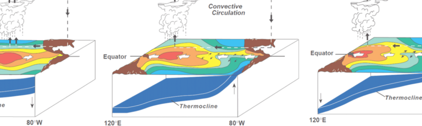
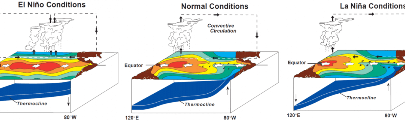
ENSO represents fluctuating ocean temperatures in the equatorial Pacific that influence global weather patterns. El Niño, or a warm phase of ENSO, is associated with increased Atlantic wind shear that historically inhibits tropical cyclone development in the basin. La Niña, or a cool phase of ENSO, is associated with decreased Atlantic wind shear that historically supports tropical cyclone development.
Illustrations of the three main phases of the El Niño-Southern Oscillation. Source: Reef Resilience
ENSO has played an important role in influencing tropical cyclone activity in recent Atlantic hurricane seasons, particularly in 2015. Last season, the basin experienced one of the strongest El Niño phases on record, which contributed to below-average activity and well-below normal Accumulated Cyclone Energy (ACE), an index quantifying total seasonal duration and intensity. .
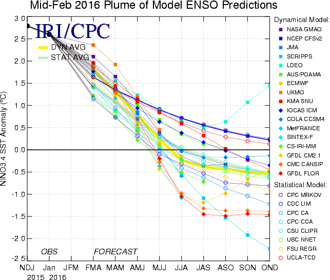
Looking ahead, the latest ENSO forecasts predict a shift out of the current El Niño phase over the next few months towards a more neutral or even a La Niña phase. The extent to which these conditions impact hurricane activity for 2016 is still to be determined; however, these conditions historically support above average activity.
Mid-February 2016 observations and model forecasts of ENSO, based on the NINO3.4 index, through December 2016. Positive values correspond with El Niño, while negative values correspond with La Niña. Sharp shifts from El Niño to La Niña are not unprecedented: La Niña conditions quickly followed the very strong El Niño of 1997-98. Source: International Research Institute for Climate and Society
The concurrence of potential changes in both the AMO and ENSO represent a unique period for 2016:
A negative AMO phase may act to suppress Atlantic hurricane activity in 2016.
A neutral or La Niña ENSO phase may act to enhance Atlantic hurricane activity in 2016.
These signals also have a range of potential implications on the RMS MTR forecast. Thus, RMS will spend the upcoming months closely engaging both the scientific community and market regarding this unique state of the basin and its potential forward-looking implications on hurricane activity. Modelers will evaluate the influence and sensitivities of new data, new methods, and new science on the MTR forecast. During this time, RMS will communicate results and insights to the broader market across a variety of mediums, including at Exceedance in May.
This post was co-authored by Jeff Waters and Tom Sabbatelli.
Share:
You May Also Like
March 31, 2021
RMS 2020 Catastrophe Review: The Year of the COVID-19 Pandemic
Tom is a Director - Event Response at RMS, and leads the Event Response services operation. He joined RMS in 2009 and spent several years in the Client Support Services organization, primarily providing specialist peril model support. Tom joined RMS upon completion of his bachelor's and master's degrees in meteorology from Pennsylvania State University, where he studied the statistical influence of climate state variables on tropical cyclone frequency. He is a member of the American Meteorological Society (AMS).