Monday, October 10
Matthew has now made its exit and work begins on the RMS loss estimate
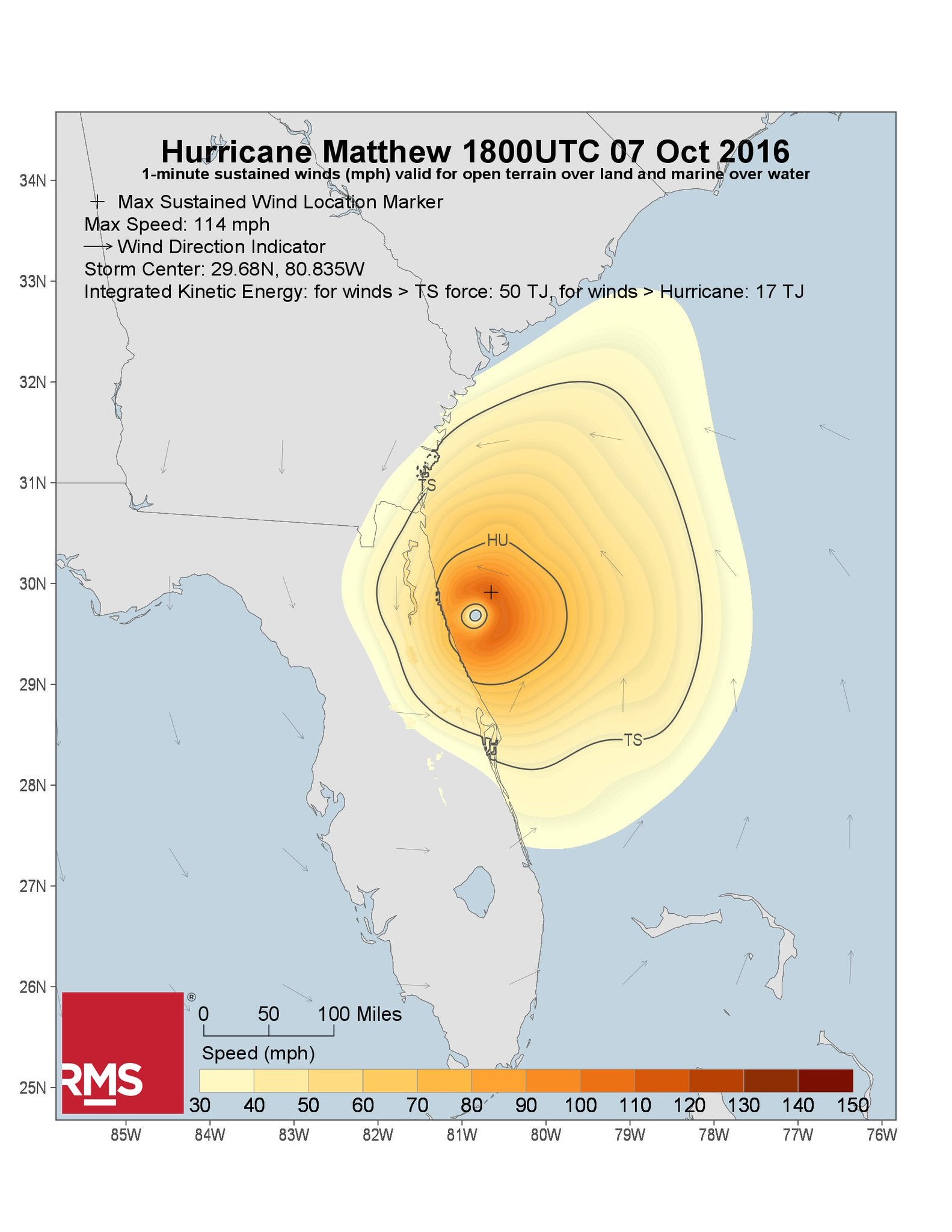
By Tom Sabbatelli, RMS hurricane risk expert
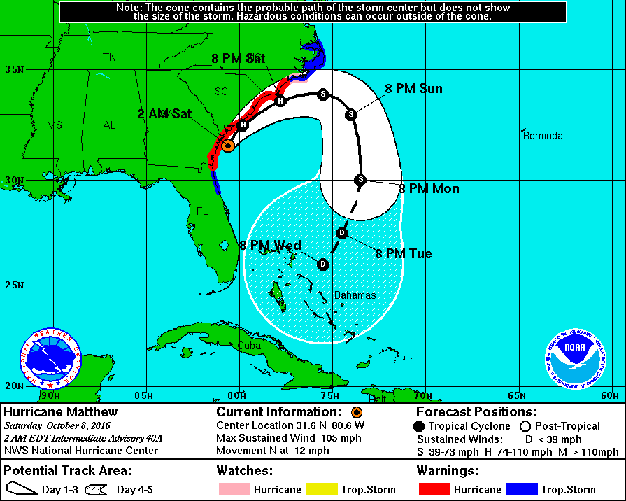
Although it may be too soon to define Hurricane Matthew’s legacy, it will surely be remembered for keeping the insurance industry on tenterhooks for a few days. Having eschewed the U-turn that had been anticipated by many forecast models, Matthew adopted post-tropical characteristics early on Sunday morning, while tracking due eastward off the North Carolina coast. With Matthew’s exit, the fears of another blow to the regions that had already been hit hard by its first impact were put to bed.
So now we have initiated the next phase of RMS Event Response operations, with our attention shifting from the regular, reactive stochastic event selections to a comprehensive interrogation of all causes of loss – both modeled and unmodeled. It is this work that will form the basis of the RMS official industry loss estimate.
Our vulnerability modelers, who make up our reconnaissance teams for Matthew, are on their way to southeast U.S. and The Bahamas. The team traveling to the southeast U.S. are likely to find the damage there is less severe than many forecasters feared prior to landfall. The fact that the storm stayed offshore for so long undoubtedly helped to reduce the potential losses across the region. Nonetheless, Matthew’s high moisture content and slow movement up the coast has caused significant and widespread flooding, driven by a powerful combination of heavy rainfall, historic wave heights, and significant storm surge.
Observations from Jacksonville, Florida and Charleston, South Carolina, as the storm passed over each city, revealed record-setting precipitable water levels. Supported by this unprecedented atmospheric moisture, Matthew produced rainfall totals in excess of one foot in many areas, including up to 15 inches of rain in Cumberland County, North Carolina.
Here the antecedent conditions were already at their peak even before the storm, due to recent heavy rain events that had deluged the region. The combination of rivers in the area already near flood stage level and the already heavily saturated soils, produced an increased susceptibility for each nuanced type of surface flooding to occur.
The antecedent conditions are essential inputs to defining the flood waters associated with this event.
While the damageable surge and wave will make up a large proportion of our modeled flood hazard, the modeled impacts of the inland flooding will be difficult to fully differentiate until our reconnaissance team have collated more observational data. Some features of this event such as dam breakage are considered a non-modeled component of this event, despite their ongoing impacts to the damage still occurring in the area.
Commercial Versus Residential Losses
RMS expects that the losses to commercial lines will be the primary driver of total flood insured losses, predominately through multi-peril or all-risks policies. We expect that the contribution to insured losses by residential claims will be limited because a proportion of the residential property losses will be covered by the National Flood Insurance Program (NFIP).
As of July 31, 2016, there were approximately 417,000 NFIP policies in-force in Georgia, South Carolina, and North Carolina. Penetration of NFIP coverage varies significantly by distance to the coastline. In coastal regions it can be as high as 25 per cent in some areas, while inland participation can be less than 1 percent. This means that although much of the storm surge-driven coastal flood losses will be covered to some extent by the NFIP, many flood-related losses further inland are expected to be uninsured.
Damage and Loss in the Caribbean
Although Matthew’s strongest winds stayed offshore in the U.S., which is likely to limit economic and insured losses, the same cannot be said for parts of the Caribbean, notably Haiti, Cuba, and The Bahamas. The RMS reconnaissance team visiting The Bahamas expect to see damage caused by high winds, storm surge, and record rainfall.
Based on reports and observation data to-date, storm surge and rainfall-induced flooding will likely drive damage in The Bahamas and other parts of the Caribbean, such as Cuba and Haiti – although for Haitians, obviously, the main concern at the moment is the terrible loss of life. Insurance penetration rates in The Bahamas are lower than those of the U.S.; however, the RMS reconnaissance team will be paying particular attention to the hard-hit islands of New Providence and Grand Bahama, home to approximately 85 per cent of the country’s insured exposure.
Calculating the RMS Loss Estimate
The insights gleaned from our reconnaissance trips will prove extremely valuable in complementing our work towards developing an industry loss estimate.
As the Event Response team now transitions from producing real-time event updates, the instrumental observations of wind and flood depth measurements they will continue to gather in the coming days will be fed into the reconstruction of Matthew’s wind and storm surge footprints. And the thorough investigation into Matthew’s damage begins as we aim to provide the insurance industry with a comprehensive review of Hurricane Matthew’s impact.
(end of Monday update 1)
Saturday, October 8
Today’s RMS response to Hurricane Matthew
By Ben Brookes, head of the RMS capital markets team; Emily Paterson, head of RMS event response; Dr Paul Wilson, RMS expert in hurricane and storm surge risk.
All times in this post are London, England
06:45 –
It’s not been often in the last 10 years that any of us have needed to set a Saturday morning alarm to catch the early National Hurricane Center (NHC) advisory for a powerful storm close to land. Thankfully, we’ve had a long streak of no major hurricanes hitting the U.S., so it’s something of a blast from the past to be back in major hurricane response mode over a weekend!
A minute or two of hitting the f5 key, and the latest is in. While the loss of life in Haiti is sobering reminder of the power of these storms, it seems the drought of major Florida landfalls continues: Matthew has continued to “stalk” the Florida coastline as the more dramatic headlines report, but it has not come ashore in the state. The track has taken it further north overnight, as anticipated, and now all eyes are on whether Matthew might have become the first land-falling hurricane in Georgia since the late 1800s
09:30
As hurricane modelers gather in the office this morning, many of whom look like they may not have been home, but revitalized by a large tray of coffees, the storm appears to be coming ashore in South Carolina. But it’s going to need a clearer picture of the inner structure of the storm before we know for sure. As yet the NHC is not reporting a landfall, but the Hwind snapshots should give us clarity soon. Whether we see a landfall next week after a loop back around is also the source of much debate. And a point of interest for the industry too – will this be one loss or two? (See yesterday’s Q&A further down this blog thread for more on this).
Our collective task this morning is to update our stochastic selection – choosing scenarios from the model that continue to represent the range of possible outcomes from Matthew, to help our clients understand the range of possible outcomes for their businesses. Once again, we’re not attempting to estimate the industry loss that this storm has caused (or more accurately, is continuing to cause), that process will begin when the storm has passed, and we can gather and collect all possible data sets, and perform detailed reconnaissance of the areas impacted, both remote and in person. RMS reconnaissance has already begun, with our remote sensing experts in full swing, and a team of our modelers headed to the affected region. On the ground inspections and observations will need to wait until the storm has passed, including any looping around that might be to come.
We begin by looking at the NHC track and cone of uncertainty, and define “gates” for each point along the track and the projected path. The set of candidate tracks is then any that pass through these same gates, with wind speeds within a defined range of the values reported by the NHC in each case. We assemble a big list of candidate scenarios, and begin to review each one in turn, discussing the pros and cons of inclusion in our selection for the day.
This morning’s NHC Advisory
First up is the Caribbean update. Even though Matthew has been out of the Bahamas for the best part of 24 hours, new information is available. Our Caribbean selection can now benefit from the work the RMS Hwind team is doing to generate a complete wind swath for Matthew. The preliminary swath proves hugely useful to make sure we don’t include modeled events with winds too far east in our set. As this work continues, it will inform our complete track selection for Matthew’s impact in the US as well. Remember to keep an eye on the @Hwind Twitter feed for rolling updates.
We spend some time debating the fact that our Caribbean track selection representing loss in the Bahamas contains numerous modeled events that do go on to cause a major disaster in Florida (and hence why these tracks do not represent what is happening in Florida) – the high pressure over the Carolinas that has steered Matthew along its unusual path has averted something far worse.
11:00
Our Caribbean scenarios are finalized, with a candidate set of 29 narrowed down to 13, the smallest modeled scenario at less than $1bn, and the largest just over $5bn (wind only).
We move on to discussing the ongoing situation in the U.S. An hour of healthy debate ensues, and from our candidate set of 20 modeled storms with U.S. impact, we settle on five that our hurricane experts feel are Matthew-like, each in different ways: track similarity, parameter similarity (Vmax, Rmax, pressure), windfield similarity, onshore impact, and various other dimensions.
Our five modeled storm scenarios range from $2bn to $8bn (wind only) – considerable uncertainty remains. It is however becoming clear that Florida at least has dodged the bullet that was heading its way on Thursday.
And as we always advise our clients, these are potential scenario losses, they represent a wide range consistent with the ongoing uncertainty, and they are not industry loss estimates of the storm itself. An industry loss estimate will be provided as fast as possible, but requires much more interrogation of many more data sources, as well as sifting through all the damage and reconnaissance reports.
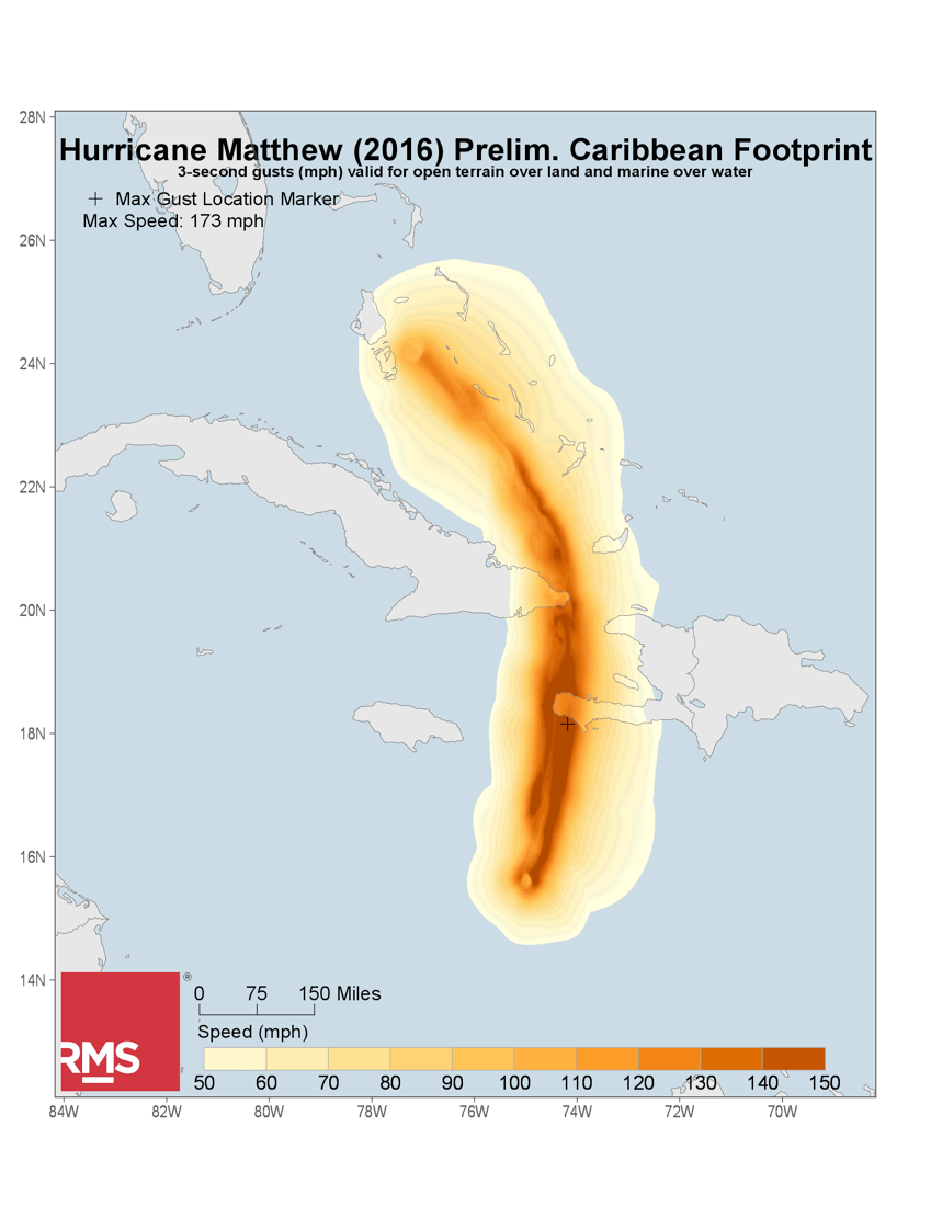
Hwind preliminary Caribbean footprint for the portion of track from Haiti into the Southern Bahamas. Note the highest wind gust marker, on the South coast of Haiti, consistent with the reports of extreme damage now emerging.
12:30
So, with today’s event selection complete, our team shifts gears again to package up the event selections to deliver to our clients via the RMS Event Response outreach process, with all associated insights and commentary. We’re already receiving inbound requests from our clients, asking when this information will be made available – looks like lunch might have to get cold – time and (storm) tide wait for no modeler!
(end of Saturday update 1)
Friday, October 7 – update 2
1800 UTC
As Hurricane Matthew continues up the Florida coast, we’ve been putting some questions to RMS experts:
Q: Florida’s facing wind damage and flooding from rain and sea storm surges – which is likely to be worst?
RMS Meteorolgists and hurricane risk experts Tom Sabbatelli and Jeff Waters
“The potential for significant wind impact is decreasing, as Matthew has remained further offshore than anticipated and the strongest winds remain tightly packed around its center. However, forecasts have the storm coming close the Georgia/South Carolina coast. The principle concern turns to the north for significant flood risk in the southeast U.S., including high storm surge risk from Jacksonville northward to Charleston, SC. As a large, slow moving storm, Matthew has been absorbing a lot of tropical moisture and building up a lot of rising water over its lifecycle. This increases the potential for heavy rainfall and significant build-up of water along the southeast coastline, which features greater storm surge potential than eastern Florida due to local bathymetry (contours of the sea bed). The size and extent of storm surge-driven coastal flooding could be worsened as it phases with the normal, daily high tide. Rainfall estimates in excess of one foot (30 cm) are expected along the coast of South and North Carolina, two areas where soils are already heavily saturated and river levels are high based on significant rainfall over the last few weeks.”
Q: How should insurers expect losses to be split between commercial and personal lines?
Tom Sabbatelli and Jeff Waters again:
“If Matthew ultimately turns out to be a flood-driven event, the insurance industry is more likely to be impacted by private commercial flood policies than residential flood, which is primarily covered by the National Flood Insurance Program (NFIP). Florida has the highest number of NFIP policies in-force (1.7 million), but there are only approximately 417,000 NFIP policies in-force combined for Georgia, South Carolina, and North Carolina. In residential areas where both wind and storm surge have occurred, we do expect some degree of what we call “coverage leakage,” a claim’s adjuster’s inability to distinguish whether damage was caused by wind or storm surge. This effect tends to increase wind policy losses, as the flood loss “leaks” into the wind payout.”
Q: What causes most damage – the hurricane making landfall or tracking up the coast?
Brian Owens, RMS expert in tropical cyclones
“This depends on a number of factors – if Matthew were to make landfall as a major hurricane and track across Florida you could get significant damage; making landfall would weaken the storm but the core of the strongest winds would definitely pass over land. If the storm tracks the coast and the eye remains offshore this would cause Matthew to maintain its intensity as it has continuing access to its primary source of energy – warm sea water. The critical factors in this second scenario are how close to the shore Matthew tracks, for how long, and how far the strongest winds extend out from the centre of Matthew. What makes Matthew particularly unusual is that it is forecast to track along the coast of four states (FL, GA, SC and NC) as a hurricane. This could accumulate damage along hundreds of miles of coastal property.”
Dr Mike Kozar, expert in hurricane risk at the RMS Hwind high definition hurricane mapping center in Florida, adds:
“The center of Hurricane Matthew has remained just offshore this morning. Based on measurements from the Hurricane Hunter aircraft, peak winds were estimated to be around 115mph at 1200 UTC. These peak winds, are found on the northeastern eyewall, approximately 40km northeast of the center. So right now it looks unlikely that the strongest part of Matthew’s wind field will come ashore in Florida, although by definition hurricanes are extremely dynamic phenomena. However, the western eyewall, and with it hurricane force winds, is located just offshore, and wind gusts have already exceed 50mph along Florida’s Space Coast.”
Q: Hurricane Nicole is having an effect – how – and is it strange that we’re seeing two cyclones in the same area at once?
Brian Owens, RMS expert in tropical cyclones
“While unusual, this has been seen before in the tropical Atlantic. Hurricanes have large atmospheric circulations and when hurricanes are close those circulations can move around each other, interfere with each other, or even merge.”
Q: Matthew is a relatively small hurricane in terms of its surface area – does this have implications for its strength and intensity?
Brian Owens, RMS expert in tropical cyclones
“There are no set rules here: you can have large intense storms and smaller intense storms too. The core of the strongest winds is generally in a small area around the eye wall. Matthew has been through its lifetime on the smaller end of size range, which has implications for the geographic scale of the damaging winds and rain. It was very intense and destructive as it tracked through the Caribbean, and while weaker now, we need to remember that, regardless of size, Matthew will potentially impact a lot of coastal regions of the U.S.”
Western eyewall continues to skirt Florida coastline as Hurricane Matthew pushes northward. Peak winds still near 115mph well offshore.
(end of Friday update 2)
Friday, October 7 – update 1
1000 UTC
As Hurricane Matthew has developed we’ve been keeping you up to date all week with insights from RMS experts. As the storm moves up the Florida coast, here’s the latest:
Emily Paterson, head of RMS event response
“According to the 06:00 UTC National Hurricane Center (NHC) advisory, Matthew is currently impacting Florida as a Category 3 storm, with tropical storm force winds impacting Miami and south east Florida through last night. Matthew has started to accelerate and its closest approach is forecast for Cape Canaveral at 12:00 UTC. Although the NHC does not forecast a direct landfall at this time hurricane-force winds are expected to be felt along the East Coast.
Hurricane Matthew is forecast to continue to track extremely close to Florida and Georgia through Friday as it moves towards the north-northeast. The storm is forecast to weaken Friday night into Saturday while moving along the U.S. southeast coast, impacting portions of Georgia, South Carolina, and North Carolina.”
Ben Brookes, head of RMS capital markets team on the possible impacts
“Having strengthened to category four status on its approach to Florida, Matthew has now weakened again but there is still significant risk to communities in its path – hence the evacuations.
It’s still a highly dynamic situation – Matthew could yet take a more easterly path, and bypass the U.S. without major areas of hurricane force winds over land – yet even in this scenario, high winds, heavy rainfall, and a large storm surge are all possible and expected. A small difference in storm track, perhaps only in the tens of miles, could bring the center of the storm on land and significantly change the storm’s impact on Florida and the southeast U.S..”
Brian Owens, RMS expert in tropical meteorology commented on the weakening of Matthew:
“From radar you can see the eyewall became more disorganised as it left the Bahamas and moved towards the coast of Florida. This was consistent with the weakening of the storm back to Cat 3 overnight. The NHC has discussed that the hurricane may be going through an eye-wall replacement cycle, which typically leads first to a weakening of the storm, followed by possible further strengthening.”
Dr Paul Wilson, expert in hurricane risk added an update on the storm surge
“Should Matthew continue to track parallel to the east coast of Florida, catastrophic damage from storm surge is less likely than a similar-sized event in the Gulf of Mexico, because the bathymetry (contours of the sea bed) off the east coast of Florida is at a steep gradient, falling away quickly. However, Matthew’s size and speed, two very important factors in determining the expected amount of surge, will ultimately influence the amount of coastal flooding. It looks like there’s a possibility Matthew might be speeding up which would reduce the risk of prolonged winds causing damage along the coast.
In some areas, Florida’s east coast contains densely populated bays and rivers that may sit at greater risk to storm surge. If winds become aligned with the orientation of a bay or river over a period of hours, it can cause the water to pile up at the end of the waterway.”
(end of Friday update 1)
Thursday, October 6 – update 3
1430 UTC
As well as monitoring the likely impacts on Florida, RMS is also analyzing the continuing impacts on the Caribbean. Dr. Paul Wilson is an expert in hurricane and storm surge risk:
“Today there’s understandably a lot of focus on how Matthew’s going to affect the U.S. But it’s still having major impact on the Bahamas.
Some commentators have been looking for historical comparisons and Hurricane Hazel in 1954 was a remarkable analogue for Matthew’s track across Haiti and Cuba. But Hazel passed through the Bahamas further to the east. A better analogue for Matthew’s current track in the Bahamas would be a storm like the 1899 San Ciriaco Hurricane which tracked further to the west.
Against today’s exposure RMS modeling would put Hazel at under US$1 billion in the Bahamas primarily from storm surge damages, while the San Ciriaco Hurricane would have been in excess of $5bn in the Bahamas. The range of losses from the pre-landfall analyses that RMS has made for Matthew encompass this range of historical loss.”
(end of Thursday update 3)
Thursday, October 6 – update 2
1330 UTC
Dr. Mark Powell and Dr. Mike Kozar are RMS hurricane risk specialistsbased in Florida. Mark pioneered Hwind real-time analysis of hurricanes with observational data from instruments in the air, in the sea and on land – including aircraft reconnaissance, GPS dropsonde instruments, sea buoys and satellites. As the storm heads towards Florida, here is Mark and Mike’s latest take on Matthew, in light of the current forecast:
“Given that Matthew’s strongest winds are confined to a very small area within its inner core, a difference of track in the tens of miles would translate to a substantial change in wind impacts both along the coastline and in interior cities such as Orlando.
Currently, landfall is most likely to occur between, West Palm Beach and St. Augustine early Friday morning. Winds will likely approach and possibly exceed hurricane force across much of this stretch of coastline, with localized flooding from storm surge, and heavy rainfall. The storm will gradually weaken as it remains very close to if not over land for much of Thursday night and Friday.
Nonetheless, other parts of the state will see effects too. Although hurricane force winds may be confined to coastal areas, torrential downpours and wind gusts will likely stretch across more than half of the peninsula as the storm progresses northward. On Friday night, Matthew is expected to continue north of this area approaching Jacksonville, as it slowly starts to curve back towards the northeast, roughly following the shape of the coastline in Georgia and South Carolina. Eventually on Saturday a subtropical ridge to the north will force Matthew to turn to the east, and potentially southeast, away from the coast into a more hostile environment that will cause Matthew to weaken more rapidly.”
(end of Thursday update 2)
Thursday, October 6 – update 1
Good morning. We’ve been asking experts from across RMS for their observations as Hurricane Matthew develops.
At 1100 UTC on Thursday 6 October, this is the first of today’s updates, from the RMS event response team:
Major Hurricane Matthew is forecast to continue tracking through the Bahamas on Thursday while intensifying from a Category 3 to a Category 4 hurricane.
At this stage there’s not complete agreement between forecasts on whether there’ll be a direct landfall in Florida, but the all projections indicate that impacts in the state could be significant. Currently, the National Hurricane Center (NHC) forecasts Matthew to track up the east coast within 30 miles (48km) of the shore with a closest approach of under 5 miles (8km) from land at Cape Canaveral. Whilst, the Global Forecasting System (GFS) and European Centre for Medium-Range Weather Forecasts (ECMWF) indicate a potential landfall somewhere between Port St. Lucie and Cape Canaveral.
It’s also set to get stronger, developing from a Cat 3 to a Cat 4 storm as it tracks towards Florida. Hurricane force winds are expected to extend 45-60 miles (75-95 km) north of the eye, which could therefore affect the entire Florida coast as the system tracks alongside it. According to the NHC, there is a greater than 40% chance of hurricane force winds affecting the coast between Boca Raton and Daytona Beach and a greater than 80% chance of tropical storm winds affecting the entire east coast of Florida north of Miami.
Both the GFS and ECMWF expect Hurricane Matthew to make a southward turn early on Sunday October 9. There is some disagreement between the forecasts for Matthew’s track into next week; GFS indicates that Matthew may make a westward turn with a potential second landfall in Florida whilst the ECMWF has the storm remaining in the Atlantic before moving out eastwards by Wednesday next week.
U.S. Tropical storm warnings are now in effect for the Florida Keys and Florida Bay whilst hurricane warnings are in place for the entire east coast north of Miami. Hurricane watches are also now in effect for the entire coast of Georgia and parts of South Carolina.
(end of Thursday update 1)
Wednesday, October 5 – update 2
We’ve been asking experts from across RMS for their observations as they monitor the progress of Hurricane Matthew. This is th second update for today please read further down this thread for the first.
At 1600 UTC on Wednesday, here’s the latest commentary:
Emily Paterson – head of RMS event response – on the current forecast:
“Matthew is expected to track through the Bahamas as a Category 4 storm through tomorrow, Thursday October 6, before tracking 45 miles (72 km) offshore parallel to the Florida coastline on Friday October 7. A Florida landfall as a Category 3 or 4 storm is possible under the current forecast, with the interaction with Tropical Storm Nicole and a mid to upper level high pushing Matthew further west. There are large amounts of insured exposure along the eastern Florida coast, which have the potential to be impacted by the storm.”
Tom Sabbatelli – RMS meteorologist and hurricane risk modeler – on the characteristics of Hurricane Matthew
“While its cloud structure may appear symmetrical, a hurricane does not feature a symmetrical wind field. In the northern hemisphere the portion of a hurricane to the right of its track typically features the strongest winds and storm surge. While still a powerful hurricane, Florida is expected to not fall within Matthew’s right hand side, as the current forecast track parallels its east coast.
If current forecasts turn out to be accurate, a movement along Florida’s east coast would make catastrophic damage from sea storm surge less likely because the east coast is ocean-facing and shelves off deeply. If it was a more gentle sloping coastal incline, like on the Gulf of Mexico, this would allow larger surges to build up. However, we are still intently watching the evolution of Matthew’s size and speed, two very important factors in determining the expected amount of surge.”
On this point, Dr Mark Powell – RMS hurricane and storm surge risk specialist – added
“The exception to this could be the densely populated bays and rivers along the East Coast. Examples would include Biscayne Bay, which extends north and south of Miami, the Indian River Lagoon system that comprises 30% of Florida’s central east coast, the Halifax River near Daytona Beach, and the St. Johns River near Jacksonville, which can be more vulnerable to storm surge especially for a slow moving storm like Matthew. If winds become aligned with the orientation of the bay/river over a period of hours, it can cause the water to pile up at the end of the bay.”
Ben Brookes – head of the capital markets team at RMS – has been continuing to assess the potential impact on catastrophe bonds and other insurance-linked securities:
“If anything, things are more uncertain today than they were yesterday – the range of forecasts seems to have widened, with everything from West Palm Beach landfall to a complete Florida bypass, or landfall in the Carolinas. There are even models predicting Matthew will make a loop in the Atlantic and further impact Florida next week.
Potential market impacts are therefore still very broad – if Matthew makes landfall in a densely populated area, or closely skirts the Florida coastline around Cape Canaveral through to Jacksonville, we could still be looking at losses that would rival anything in recent history. But that’s a big “if.” In a scenario like this, we could see the ILS market impacted, and with significant bond exposure in Florida, a major industry loss would be highly likely to also mean losses to outstanding cat bond principal.
On the other hand, it remains quite possible for Matthew to stay further offshore, or for the damaging winds to affect less populated areas. As yet we could still be looking at a low-single-digit billions industry loss event, which would mean very little impact to the ILS market.
What’s clear is that the uncertainty that’s unfolding is likely to create trading interest – the market is closely monitoring what’s going on, and in some cases actively hedging.”
(END OF WEDNESDAY UPDATE 2)
Wednesday, October 5 – update 1
Latest update from Dr Mike Kozar and Dr Mark Powell, experts in hurricane risk based in Tallahassee, Florida – RMS’ center for HWind high definition hurricane impact mapping.
There was a possibility that Hurricane Matthew might have weakened yesterday as it travelled over Hispaniola, the large island comprised of Haiti and the Dominican Republic. But Matthew’s center only skirted Haiti’s mountainous terrain and quickly returned over water, and so its strength did not diminish much. The storm continued northward through the Windward Passage during the afternoon, maintaining its intensity between 130 mph and 140 mph according to measurements from the U. S. Air Force Reserve Hurricane Hunters.
The 0000 UTC Wednesday morning HWind analysis indicated that Matthew made landfall on the eastern tip of Cuba with hurricane force winds extending about 50 miles westward. Matthew’s short time over land will limit the interaction with Cuba’s terrain so the storm is expected to regain intensity shortly after emerging back over the ocean near the southern Bahamas. The storm is expected to continue generally northward through the Bahamas on Wednesday before threatening the United States on Thursday and Friday.
In the last 24 hours, model consensus has shifted the effects of the storm westward, making impacts along the Southeast coast of the United States more likely. As Matthew approaches Florida, the storm is expected to slowly weaken in the next day or two, owing to increased vertical wind shear. Overall, the threat to Florida, Georgia, and the Carolinas will be determined by the exact track of the storm, particularly how far west it reaches as it interacts with the subtropical ridge while moving northward up the coast.
The general model consensus suggests that Matthew will slide northward very near, if not scraping along, the Florida coastline as a strong hurricane, making at least tropical storm force winds, high surf, and heavy rain likely for most of the cities along Florida’s East Coast, which has not seen a direct landfall from a hurricane since Katrina in South Florida in August 2005 (Hurricane Wilma struck the Gulf coast in later in 2005 and more recently Hermine struck the panhandle earlier this year).
Beyond potential impacts to Florida, the forecast into the weekend is still quite uncertain, as the position and strength of the subtropical ridge will determine whether or not Matthew will continue up the coast or meander off of the Southeast coast before heading out to sea.
(END OF UPDATE)
Tuesday, October 4
Major Hurricane Matthew is one of the most powerful North Atlantic hurricanes in recent history, having briefly reached Category 5 strength on Saturday October 1 and the strongest hurricane anywhere in the Atlantic since Hurricane Felix in 2007, which also tracked through the Caribbean Sea.
Below we have expert commentary on the storm from Ben Brookes, Emily Paterson, and Dr. Michael Kozar, and we will be posting further updates here on the RMS Blog as the event unfolds over the next few days.
Ben Brookes, Vice President, Capital Markets at RMS, said: “There are a number of public catastrophe bonds exposed to Caribbean windstorm, the vast majority of which only have exposure in Puerto Rico. At this time Hurricane Matthew is far enough from Puerto Rico to be unlikely to cause a significant impact. There are no publicly issued catastrophe bonds on risk solely covering Caribbean exposures. If present, Caribbean exposure typically makes up a small proportion of exposed limit alongside U.S. and Canadian exposure.
NHC hurricane watches or warnings are in effect for Jamaica, Haiti, Turks and Caicos and certain regions of Cuba and the Bahamas, all of which except Cuba are member nations of the Caribbean Catastrophe Risk Insurance Facility (CCRIF). CCRIF provides insurance coverage on a parametric modeled loss basis to member countries and sponsored a catastrophe bond in 2014 issued from the World Bank’s Global Debt Issuance Facility alongside its traditional reinsurance program.”
+++
“Flooding and landslides are a big concern from Hurricane Matthew in the Caribbean, and are likely to be a major contributor to damage from the storm. The slow-moving nature of Matthew is allowing the storm to build up moisture, which can result in heavy rainfall as the system passes over land,” said Emily Paterson, head of event response at RMS.
While Matthew is still a Category 4 major hurricane, the wind-field is relatively small, with hurricane force winds only extending 40 miles (65 km) from the center. Matthew is making landfall along the edges of Haiti and Cuba, and therefore we expect wind damage to be relatively localized.
Storm surge from Matthew is another concern. Matthew’s strong winds can cause significant storm surge in the Caribbean. Many of the islands in Matthew’s track have multiple bays, which have the potential to amplify storm surge by not allowing the water to flow away to the side. Furthermore, as Matthew has a fairly linear track, this also amplifies the risk of high waves and storm surge.
We are keeping a close eye on Matthew’s extended 4-5day forecast, which has the storm tracking very close to the U.S. coastline off Florida and the southeastern states, before making landfall in the U.S. in the Carolina region at Category 2 strength. There’s still a fair amount of uncertainty at this lead time though.”
+++
Dr. Michael Kozar, hurricane risk specialist at RMS, notes: “Matthew has a thermodynamic environment that could potentially support a very intense hurricane as it moves up the Gulf Stream over water with sea-surface temperatures of above 28°C.
With respect to the slow forward speed of Matthew, if a storm sits on top of its own cold wake it can weaken. However, in Matthew’s case, the sea surface temperatures across the northern Caribbean and around the Bahamas are well above 28°C. Furthermore, warm water seems to exist well below the surface, based on maps of various isotherm depths and ocean heat content. Given how shallow water is near the Caribbean Islands, upward mixing of cold water may not be a huge limiting factor on the storm’s intensity, until it pulls further north into colder waters or northeast off the continental shelf.
A more significant factor for a cap in Matthew’s intensity, besides the amount of time it spends near/over land such as Hispaniola and Cuba, is wind shear and dry air. Forecasting the impact of wind shear on Matthew has been quite tricky thus far as Matthew has been located just south of an area of moderate to high shear for quite some time. If the shear north of the system holds its ground, Matthew very likely will weaken.
Furthermore, there also appears to be some dry air in the mid-levels that could suppress intensity as Matthew pulls poleward away from the Caribbean and into the Western Atlantic. All of this does point to weakening as the storm moves northward, but keep in mind the model consensus has been calling for some degree of weakening for a day or two. Yet Matthew’s intensity largely just oscillated up and down over the course of the weekend and into today.
Regardless, the inner core of Matthew is quite small, so the large scale impacts from wind may be secondary to the impacts from rainfall, save for within about 50 miles of the center.”
+++
Based on RMS reconnaissance trips to the area in 2015 as part of the research conducted to update the RMS North Atlantic Hurricane Model in 2017, the RMS view of vulnerabilities by island is below:
Haiti: In Haiti the main concern is rainfall, since with steep terrain much of the country is exposed to flooding and landslides which could be the biggest source of issues in the most populated areas if they aren’t hit by high winds. And certainly the most exposed areas along the southern coast look like they will be hit hard. It is expected that much of the local building stock has been built in recent years, following the 2010 earthquake that devastated the country. The Haitian government instituted a new building code in 2012, in direct response to the earthquake, but it is unclear to what extent this new building code is being enforced. RMS research does, however, indicate that buildings in Haiti are expected to perform worse than most Caribbean islands, although this varies by individual construction type. Insurance penetration in Haiti is expected to be low.
Cuba: While market knowledge of vulnerability in Cuba is low, research into the area by RMS shows us that, despite being older on average, the building stock performs well overall due to the high presence of concrete construction. Insurance penetration is also expected to be low.
Jamaica: Building codes in Jamaica have not had a major revision since the first building code was enacted in 1908. However, RMS reconnaissance and research shows that single-family homes are built by local engineers to high standards; reinforced concrete construction is very prevalent across the island. In 2012, Jamaican engineers adopted many practices outlined in recent International Building Code (IBC) standards, which are likely to be enacted in newer commercial construction.
Bahamas: Insurance Penetration in the Bahamas is understood to be higher than other Caribbean islands, although lower than hurricane-exposed regions of the U.S. However, RMS analysis suggests that the Bahamas, with a long history of building codes, exhibit better construction quality than most of the Caribbean. The predominant construction material is reinforced concrete, although amongst the Family Islands there is a higher proportion of wood construction, leaving these islands potentially more vulnerable to wind damage. Despite being well attached to the walls, roofs in the Bahamas often feature asphalt shingles, which can increase the vulnerability of the roof and the entire structure. RMS reconnaissance shows that insured property accounts for less than 40 percent of all homes; one estimate places single-family dwelling insurance penetration at near 20 percent. Commercial exposures are more likely to be insured than residential exposures.