Every twist and turn of a real-time hurricane can affect global financial markets, public safety, or government and international aid agencies that provide assistance. Within the (re)insurance space, the ability to understand forecast track, timing, and potential hazard and loss impacts before landfall helps entities to prepare and execute their event response processes effectively. This includes having adequate capital to cover claims, setting up claim centers and planning policyholder outreach, securing and positioning adjusters in areas that are likely to be impacted, and determining what, if any, risk can be ceded to reinsurance or capital markets.
For our clients, the traditional approach to quantify potential impacts ahead of a landfalling storm involves selecting similar storms from the RMS® North Atlantic Hurricane (NAHU) stochastic event set. While this generates vital insights that can be extracted quickly from internal databases, there are opportunities to provide earlier and more comprehensive insights into the storm ahead of landfall.
To date, RMS clients have also benefited from real-time analysis of hurricane events through RMS HWind Real-Time Analysis products. These observation data-based snapshots and footprints have provided the industry with a standard “ground truth” representation of tropical cyclone wind field size and intensity before, during, and following landfall effectively helping to describe what the storm is doing and what the storm has done.
Building on this framework, RMS has expanded its HWind Real-Time Analysis offering to include a forecasting solution for all named tropical cyclone events in the North Atlantic Basin. This was developed using a proprietary methodology that combines real-time forecast track data from weather forecasting models, HWind data, and the RMS North Atlantic Hurricane Models modeling framework. The forecasting products consist of five-day forecast track scenarios, gust probability analytics and individual forecast hazard footprints made available every 12 hours once the storm has been named.
Cooking Up Forecasting Spaghetti: Making Sense of Track Forecasts
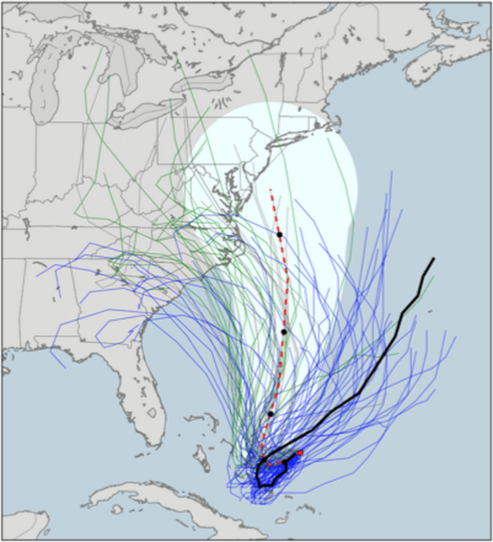
There is a sea of track forecasting information available via Numerical Weather Prediction (NWP) centers across the globe. Adding up all these available weather forecasting models results in over 100 different track forecasts for any given storm, forming an intractable “spaghetti” of solutions. Differences in these solutions can be due to a number of things that can vary by model, including the underlying physics governing the atmospheric and oceanic patterns, weak or complex steering flows, or the timing of a storm’s interaction with approaching large-scale weather systems (see figure below for example for Hurricane Joaquin in 2015).
Figure 1: Ensemble track forecasts for Hurricane Joaquin across multiple sources issued at 11 a.m. ET on September 30, 2015. NOAA GFS model ensemble track forecasts are in green, ECMWF ensemble forecasts in blue, the National Hurricane Center forecast in red, and the actual track followed by Joaquin in black.
While hurricane track forecasting has improved steadily over the years as models have been upgraded with better data assimilation systems, new data sources, and higher resolution grids, considerable uncertainty remains. It’s critical to be able to account for the true spread in the track forecasts – which varies for each storm – in order to get an accurate idea of the range, likelihood, and uncertainty of each of the possible track scenarios.
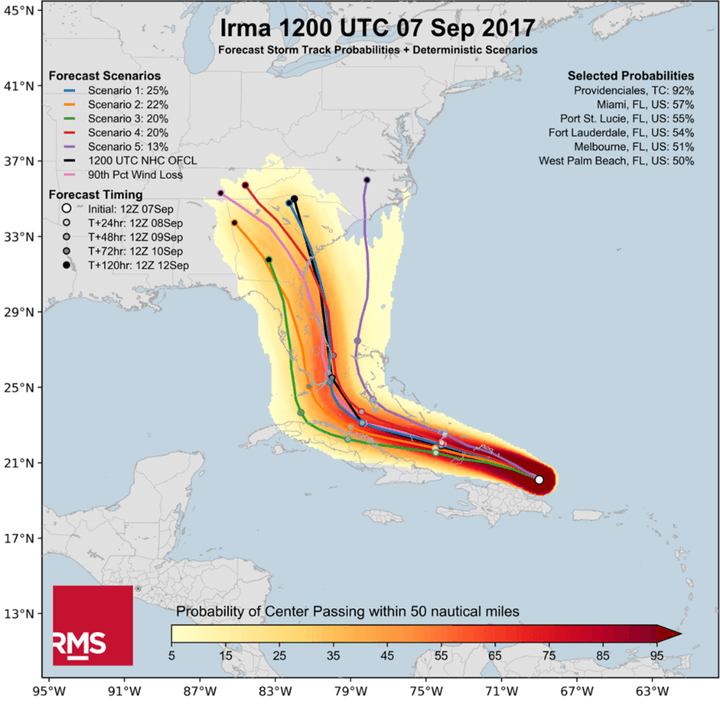
RMS hurricane scientists have just completed a four-year research and development cycle to provide the first RMS multi-model tropical cyclone forecast solution for the (re)insurance and financial industries. This proprietary methodology assesses all the “spaghetti” for named real-time storms in the Atlantic across 100+ NWP models and consolidates it into the few useful strands, or clusters, that represent a probabilistic view of the track forecast over the next five days. That view comes in the form of several individual track scenarios, one of which is the National Hurricane Center (NHC) track, as well as a track density grid that indicates the likelihood of the storm center passing any specific location.
The solution has been backtested on 17 tropical cyclones from 2011-2018 and meets modern metrics for forecast skill and reliability. Collectively, the track forecast scenarios help users make sense of the available track forecast data and forecast uncertainty in a digestible way that informs timely insights and decisions ahead of landfall.
Figure 2: Sample track probability grid and track forecast scenarios for Hurricane Irma (2017), based on the 1200 UTC forecast data on September 7, 2017
Why Not Just Use the National Hurricane Center Forecast?
The NHC does a good job distilling all this information into one forecast and it typically beats all other forecasting models on average. The NHC also provides some information on uncertainty by providing an error cone on its graphical forecast chart. Unfortunately, the cone has nothing to do with the event at hand or the actual track uncertainty of the current evet. Rather, it’s based on the last five years of forecast error information.
Uncertainty needs to be clearly highlighted. It’s important to recognize cases in which the uncertainty is greater (or less) than the past five years of forecast errors. It’s especially important to provide insight when model forecasts do not agree or tend to cluster along preferred tracks.
As part of the HWind forecasting solution, RMS produces an experimental HWind Track Forecast Confidence Score at each forecast cycle and provides an index to evaluate the spread of the forecasts, providing insight for uncertainty relative to the NHC cone.
Beyond the Track: Forecast Hazard and Loss
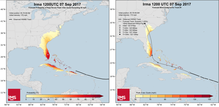
As part of the forecasting solution, RMS utilizes HWind data and the RMS NAHU modeling framework to develop gust probability metrics and individual hazard footprints for each of the track forecast scenarios. The real-time HWind analysis of measurements collected in the storm by reconnaissance aircraft and many other observational data sources helps RMS scientists bias-correct the intensity and wind fields of the forecast tracks. Similarly, utilizing the NAHU modeling framework ensures that the resulting hazard footprints are consistent with how RMS models hurricanes today.
Figure 3: Sample 50-mph gust probability grid (left) and individual forecast wind hazard footprint (right) for Hurricane Irma (2017), based on the 1200 UTC forecast data on September 7, 2017
Clients can analyze the individual forecast footprints in RMS RiskLink relative to their portfolios or exposures of interest to quantify potential modeled losses, including the applied vulnerability curves and financial terms and conditions. With this information, clients can construct their own view of risk ahead of landfall taking into account the uncertainty of the forecast solutions.
Overall, the HWind forecasting products support many event response applications, including the ability to understand track forecast track, timing, and uncertainty up to five days before landfall, and the ability to quantify potential losses for each scenario against exposure(s) of interest.
Collectively, the products complement many of the existing RMS event response tools that are available today as we aim to help the market at every stage of a hurricane event response process, from pre-landfall to post-event loss estimates and analysis. Getting closer to the true picture will help the industry to plan and respond better.
Mark leads the RMS office in Tallahassee Florida. For over 30 years, Dr. Powell served as a scientist at NOAA’s Hurricane Research Division in Miami, where he invented the HWIND technology for high definition hurricane impact mapping. He is a Fellow of the American Meteorological Society and holds the AMS Certified Consulting Meteorologist designation. He has published over 80 papers in a variety of peer-reviewed journals on the hurricane boundary layer, air-sea interaction in extreme winds, new metrics for hurricane destructive potential, and hurricane risk. He also served as a developer and Meteorology Team Leader for the Florida Public Hurricane Loss Model.
Michael Kozar
Michael is a senior modeler on the RMS HWind team based at the Tallahassee, FL office. Michael has a bachelor's and a master's degree in Meteorology from Penn State University and a PhD in Meteorology from Florida State University. He has experience forecasting and analyzing tropical cyclone wind fields and has also studied interannual hurricane variability in the North Atlantic.