Junichi Sakai
Principal ModelerJunichi Sakai is a Principal Modeler for RMS, based in Tokyo.
Log In
Access all customer product support, event response, and training in one place
LifeRisks PortalFind modeling tools based on best practice actuarial techniques and medical science
Miu PortalExplore analytics and risk insights for the alternative capital market
Insurance Solutions
Formerly Moody’s RMS

Typhoon Faxai was the strongest landfalling typhoon to impact the Greater Tokyo area since Typhoon Ma-on in 2004. Making two landfalls as it traveled across the Tokyo Bay, Faxai made a brief landfall over the Miura Peninsula, Kanagawa prefecture in the Kanto region of Japan, just 35 miles (57 kilometers) south-southwest of Tokyo early morning local time on Monday, September 9.
It then tracked northeast to make a second landfall over the city of Chiba (pop. ~979,000), Chiba prefecture, 20 miles (32 kilometers) east of Tokyo. Maximum sustained wind speeds at its landfalls were equivalent to a Category 2 hurricane on the Saffir-Simpson Hurricane Wind Scale. Just four days after, RMS reconnaissance was in Chiba prefecture, surveying the damage.
On September 26, RMS released its best estimate for Japan insured loss from Typhoon Faxai (1915) at between US$5.0 and US$9.0 billion (¥500 to ¥950 billion). This estimate includes property damage and business interruption caused by typhoon wind and coastal flooding to residential, commercial, industrial, marine, and automobile lines – and includes both the private and kyosai/mutual markets. Additional factors for post-event loss amplification, and for non-modeled losses are included in this estimate.
The estimate is informed by analysis of the RMS reconstructed wind field and coastal flood footprint through the RMS Japan Typhoon High-Definition (HD) Model. In addition, the industry loss estimate includes data and insights from field reconnaissance conducted by modelers based at the RMS Tokyo office.
Two reconnaissance phases were carried out; the first was just four days after landfall, examining several sites of wind damage in Chiba prefecture. The second phase on September 19, modelers visited several sites of wind and coastal flood damage in Kanagawa prefecture. RMS clients can access the report via RMS Owl.
During the first phase, the RMS team visited eight damaged cities and towns along the western coast of Bōsō Peninsula in Chiba prefecture, from Tateyama-shi in the southwest tip of the peninsula, moving northeast to Ichihara-shi.
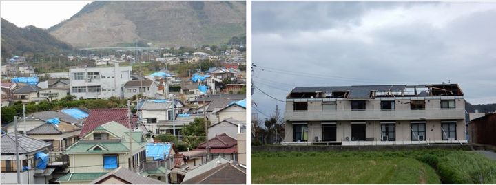
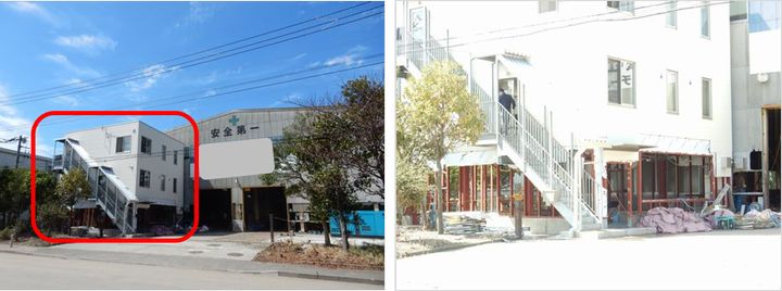
The towns of Hota and Awa-Katsuyama in Kyonan-machi were the most severely damaged. The team observed that most of buildings in the towns suffered some damage to roofs, exterior walls and/or windows, and some of the damage was very severe. Severe damage impacted townhouses, a small industrial facility, a convenience store and a bank. In Kimitsu-shi, the RMS team saw some severely damaged car dealerships and restaurants.
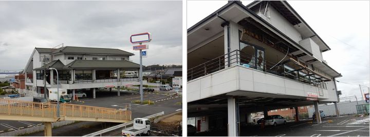
The second phase saw the team visiting the Miura peninsula in Kanagawa prefecture, across the Tokyo Bay from the Bōsō Peninsula, and focused on four damaged cities – Fukuura, Kanazawa-ku, Yokohama-shi, Yokosuka-shi and Miura-shi. Fukuura experienced severe structural coastal flood damage as observed along the coastline. Wave height was approximately two meters. There was damage due to inundation, but no structural damage was observed for buildings that were located one (or more) blocks away from the coastline.
Some severe roof damage was observed for single family dwellings, a gas station and some restaurants in Miura-shi, where the eye of typhoon passed through.
Using on-the-ground reconnaissance close after an event provides RMS with information to support modeling and our industry loss estimate.
Junichi Sakai is a Principal Modeler for RMS, based in Tokyo.

