Moody's RMS Europe Windstorm HD Models Unify Climate Modeling to Enhance Risk Selection Across the Continent
Giovanni LeonciniSeptember 20, 2022
Flood, hail, and convective storms have dominated conversations in the European insurance market in recent years. This is driven by significant catastrophic events such as the 2021 Western and Central Europe Floods, with insured losses estimated by Moody's RMS to be between €10 billion and €13.2 billion.
Severe thunderstorms and convective weather in France earlier this year saw insured losses of €3.9 billion according to France Assureurs. And the February 2022 storm series of Ylenia, Zeynep, and Antonia (named Dudley, Eunice, and Franklin by the U.K. Met Office) also reminded us that European windstorm remains a material risk despite recent low storm activity. According to Moody's RMS, Zeynep and Antonia generated an estimated combined loss of between €3.0 billion and €4.5 billion.
The regional variability in trends and the uncertainty of European floods, severe convective storms, and windstorms have also been highlighted in the latest Intergovernmental Panel on Climate Change (IPCC) report, showing how complicated climate dynamics can be. An additional layer of complexity also affects loss trends that, at least in the short term, are driven by socioeconomic changes, such as economic growth that can lead to higher property values.
The complex dynamic between these perils and their regional variation creates unique challenges for (re)insurers to ensure adequate capital and Solvency II positions.
Introducing the Moody's RMS Europe Windstorm HD Models – Completing the Europe Climate HD Model Suite
We are pleased to announce the launch of the Europe Windstorm HD Models – completing the full suite of Moody's RMS climate HD Models™ for Europe, which already includes both the Europe Severe Convective Storm and Europe Inland Flood High-Definition (HD) Models. These models, combined, offer customers a consistent view of climate risks across Europe.
The overall framework of the new Europe Windstorm HD Models reflects the long experience Moody's RMS has acquired in modeling windstorm risk over the past decades, with all components now rebuilt using state-of-the-art techniques. This new release brings many significant modeling enhancements to the market, a few of which include:
Uses the latest version of the Community Atmosphere Model plus the Weather Research and Forecasting Model, to estimate wind gusts with increased resolution and simulation length and provide a larger event set including more events in mid and long return periods
New extreme value theory methodology, resulting in better tail estimates of observed wind gusts
Longer record of historical data for calibration, including the recent period of low storm activity
Incorporates an additional 45 percent of claims data into vulnerability calibration than in the previous release
Furthermore, the wind domain has been extended to Finland and the storm surge now considers the whole of the U.K., Ireland, Belgium, and France’s Atlantic and northern coasts.
Building a Consistent View of Market Risk across Europe
HD modeling provides a common framework for the analysis of flood, severe convective storms, and windstorm risk in Europe. By running all your models on Moody's RMS Risk Modeler™ application, you benefit from a unified view of risk as the models share the same exposure data, building inventory, simulation engine, vulnerability approach, and last but not least, the same financial engine.
To build a more consistent and correlated view of Europe wind risk, we have retired the 'high-frequency' windstorm model component. This component was included in previous versions of the RiskLink™ Europe Windstorm Models, to represent attritional convective wind risk which contributes to annual windstorm losses.
However, with the release of Moody's RMS Europe Severe Convective Storm HD Models in 2020 which models the full spectrum of convective wind and hail events, this 'high-frequency' component is no longer required in the Moody's RMS Europe Windstorm HD Models.
With the ability to group analyses across perils and to run climate-conditioned views of individual risks, Moody's RMS makes it simple to develop a more complete view of European market risk. Confidence in the risk view can be further strengthened because the Risk Modeler application allows model users to initiate deep dives into the data to identify the loss drivers, for example, across locations or perils.
This detailed information helps the user build a comprehensive view of the risk across the continent, which can inform pricing, risk selection, treaty structures, as well as the downstream risk management workflow.
HD Modeling Innovations Deliver a More Realistic View of Event Losses
The new Europe Windstorm HD Models leverage the power and scale of Moody's RMS Intelligent Risk Platform™ to run more robust analyses on your portfolio. First, the simulation engine: The cloud-based framework allows for a very large number of simulations to improve the robustness of the models.
The models feature over 600,000 events spread across 50,000 simulation years to provide sound estimates of tail risk. The simulation length of 50,000 years is also purposefully aligned with the simulation lengths in the Europe Severe Convective Storm and Europe Inland Flood HD Models to make grouping across perils easy.
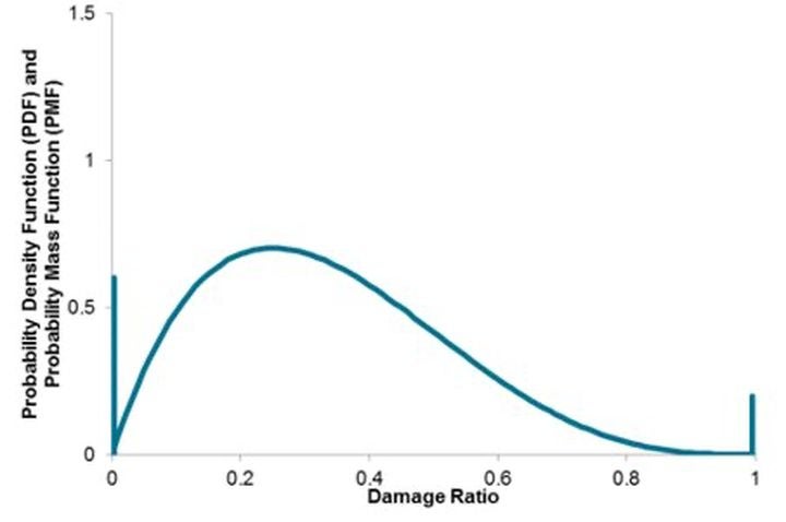
Finally, the HD-model framework delivers a four-parameter vulnerability representation of losses on the Risk Modeler application. This representation allows the model to explicitly capture the probability of zero and total loss, which helps build a more realistic view of losses. Explicitly capturing the probability of zero damage is particularly important for European windstorm, which is characterized by large areas of very low mean damage ratios, with only a small proportion of buildings receiving any damage at all.
The graph below visualizes a sample distribution of damage for a given risk subject to wind. The spike at 0 indicates the probability that the risk incurs no damage at all. The spike at 1 represents the probability that the risk faces a total loss. The central distribution represents the probability of a range of possible conditional damage ratios that could occur from minor to major damage except for complete damage.
Sample four-parameter vulnerability for European windstorm peril
Leveraging the Latest Science and Data
The new Moody's RMS Europe Windstorm HD Models have been completely rebuilt and leverage the latest science and data. Available on Moody's RMS Intelligent Risk Platform and through associated applications such as Risk Modeler, the windstorm models allow a seamless integration together with the Europe Severe Convective Storm and Europe Inland Flood HD Models.
The common HD-model framework and data enable a consistent risk view across the three perils to facilitate deeper analyses and risk management workflows. The Europe Windstorm HD Models will be available in Spring 2023 along with associated Aggregate Loss Model (ALM®) profiles and a climate-conditioned view of risk (climate change model) available soon after.
Learn more about the European windstorm models on our website.
Over the course of this winter, RMS has been publishing a series of blog posts charting the progress of the 2017/18 European windstorm season. In October last year, we outlined our forecast for a stormier-than-recent season, before checking in with an update at the end of November following three notable autumnal windstorm events. Following a relative lull in activity in December, we used the fiftieth anniversary of the “Glasgow Hurricane” as a reminder of the potential impacts when strong windstorms directly hit major urban areas.
However, at the start of 2018 this lull was broken with the arrival of storm Eleanor (U.K. Met Office/Met Éireann) / Burglind (Freie Universität Berlin), motivating us to once again check-in on the progress of the storm season. Here we outline the meteorology and impacts of this latest storm, and discuss how it fits into the seasonal forecast issued at the start of the season.
The Story of Eleanor/Burglind
Storm Eleanor/Burglind became prominent just into 2018 on January 2, as a wave along the cold front of a strong primary low situated to the southwest of Iceland. Under the influence of a strong westerly jet stream, this wave developed into a rapidly intensifying secondary low which attained a minimum pressure of 966 hPa as it moved east across Scotland. As the storm continued to track to the east across the North Sea to Denmark, it caused strong winds to the south covering a broad swathe of western Europe. Storm winds were experienced in Ireland, U.K., France, Netherlands, Belgium, Luxembourg, Germany, and Switzerland; while high waves pounded the northern coast of Spain.
The RMS Event Response process aims to provide our clients with near real-time insights into ongoing catastrophes, and to provide strong modeling deliverables to assist during major events. Our first job following an event is to assess the likely magnitude of insured damage to ensure that we respond appropriately to meet the needs of our client base. This is often a difficult process, subject to significant uncertainties, as in the immediate aftermath of a storm we must work with partial information — before all weather station data is available for review, and long before the full suite of insurance claims has been counted. However, in the case of Eleanor/Burglind, it quickly became apparent that the observed wind gusts were not indicative of a major loss-causing event.
The footprint for this storm was large and noisy. Peak gusts were typically below 30 meters per second (m/s), though some parts of Switzerland, eastern France, and southwest Germany experienced gusts slightly above 30 m/s. For comparison, gusts well in excess of 40 m/s impacted areas of significant exposure during some of the most extreme historical windstorms. Gusts of up to 48 m/s were measured around Paris and neighboring areas during storm Lothar in 1999; 44 m/s was observed near London during storm 87J; and gusts of 46 to 47m/s were observed throughout central Scotland during the 1968 “Glasgow Hurricane”. Gusts across the full extent of the Eleanor/Burglind footprint were also generally lower than those observed during recent storms where losses exceeded €1 billion, such as Emma and Xynthia.
Based on the early weather station data, we concluded that Eleanor/Burglind would cause widespread minor damage, with some pockets of more significant damage, and would not lead to the kind of aggregation of claims needed to form a major European windstorm loss. Assessment of news reports after the event confirmed that this was indeed the nature of the damage being observed on the ground, and RMS clients can refer to the RMS Event Summary on January 4 for more details of observed damage.
Reflecting on this event almost two weeks later, we now have additional tools at our disposal when trying to understand the impacts of this storm. Insured loss estimates have been issued by national insurance associations, which are collectively in line with the RMS assessment of insured loss from this event. In Germany, the GDV expect insured losses to be significantly below €500 million, consistent with other estimates of €200-300 million for that market; in France, the FFA issued a combined loss estimate from the Carmen and Burglind storms of €200 million; in Switzerland, media reports suggest losses of €60-90 million; and in the Netherlands, the Dutch Association of Insurers figure is €10 million. As these figures include flood losses, as well as storm Carmen losses in France, we believe that a fair wind-only estimate arising from these reports is around €400 million.
Furthermore, the RMS windstorm modeling team, based in major markets in Europe, has had wide-ranging interactions with the market since this event, revealing a consensus view that is broadly in line with these insurance association loss estimates.
The latest available information thus supports the early RMS view that, like storms Xavier and Herwart earlier in the season, Eleanor/Burglind was a notable storm without being a major event from an insured loss perspective.
Half-time Analysis of the 2017/18 Europe Windstorm Season
In line with the RMS season forecast, the current season is so far proving to be stormier than the recent average. However, as was outlined in the blog, the relationship between storminess and loss is an imperfect one. Thus far, despite being a fairly stormy season, estimated aggregate industry losses in Europe to date remain low compared to what might be expected given the long-term average annual loss (AAL) — although in Germany they may have aggregated to around half the long-term AAL at this point.
We are currently halfway through the peak December-January-February period of the 2017/18 season, and it only takes one major event to change the whole nature of the season from an insurance perspective. Over the last few days we have been monitoring another depression (named Friederike by Frei Universität Berlin) due to cross Europe in the next 24 hours. This is now forecast to be a relatively shallow depression moving quickly over Europe, reminiscent of storm Xavier (October 5, 2017).
Whether this storm produces slightly higher or lower losses than Xavier will be sensitive to the gust speeds experienced in urban areas within the forecast footprint, such as Rotterdam and Dortmund. It is interesting to note however that predictions of the severity of this storm have abated over the past couple of days, reflecting the high levels of forecast model uncertainty affecting the very mobile, developing systems responsible for most major loss events.
As the number of minor windstorms impacting Europe this season grows, we are left to wonder how many more “near misses” can we experience before our luck runs out?
Giovanni has worked in the (re)insurance industry for the last 10 years with research and development roles for Property and Casualty at Zurich Insurance and Aspen Re. Previously he was a researcher at the Met Office and the University of Reading where he focused on convective scale ensembles.
He obtained his PhD in Meteorology from Colorado State University and a MSc from San Jose State University, and has earned his Laurea in Physics from the University of Bologna.