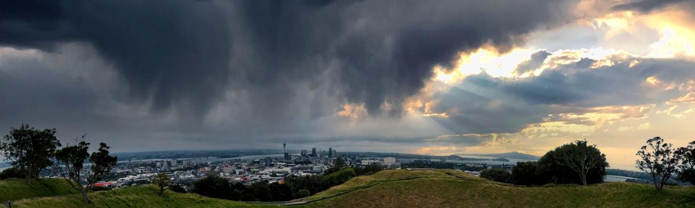
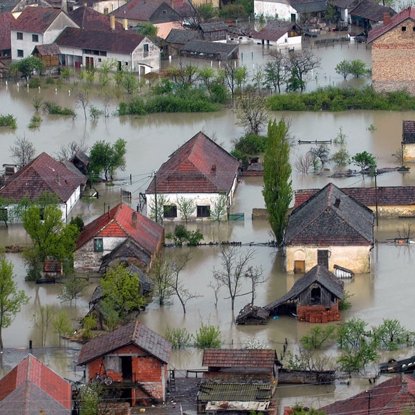
Catastrophic flooding was reported across parts of the North Island of New Zealand on Friday, January 27, including the country’s biggest city, Auckland, where numerous areas were inundated with more than a meter (3 feet) of floodwater.
Auckland Airport’s international terminal was also flooded, leaving thousands of passengers stranded. Leisure activities and sports events were widely canceled.
Fire and rescue services responded to over 1,000 calls for assistance, and several thousand properties were left without power. The extent of damage, displacement and disruption prompted local authorities to declare a state of local emergency on Friday, January 27.
According to preliminary damage information from Auckland Emergency Management, a part of Auckland Council working in partnership with emergency services and other organizations to ensure effective coordination of civil defense and emergency management, as of Thursday, February 2, more than 19,000 properties in Auckland were confirmed as damaged. This total is expected to rise as damage assessments are completed.
At this preliminary stage, insurance claims stand at nearly 20,000, a figure which is expected to rise as home and business owners return to their properties to assess the impact.
The event could be the costliest weather-related event in New Zealand history, with a spokesperson for the Insurance Council of New Zealand remarking that the event is very significant and will result in a lot of claims.
What Drove the Record Rainfall?
This record-breaking rainfall stemmed from a complex interaction between two weather systems over the South Pacific. As the remnants of a former tropical cyclone drifted south-southeast last week and approached New Zealand from the northwest, an area of high pressure concurrently developed and strengthened to the east of the country.
The blocking high to the east prevented the approaching low from crossing the country, and the North Island of New Zealand found itself at the center.
The resulting line of convergence paired with southerly low-level jet winds produced a conveyor of moisture-laden air all the way from the tropics, a meteorological phenomenon commonly referred to as an ‘atmospheric river’, with the North Island in the firing line.
Figure 1: Video from National Institute of Water and Atmospheric Research showing the atmospheric moisture levels over New Zealand between January 25-29, 2023. Source: NIWA Twitter
The stream of moisture produced record amounts of rainfall across the city of Auckland and neighboring areas on the North Island. Auckland Airport received 258 millimeters (10.1 inches) of rainfall on Friday, January 27, a new record.
Some parts of Auckland were hit with more than 150 milimeters (5.9 inches) in the space of three hours, and hourly rainfall rates in some areas of the city reached a staggering 50–70 millimeters (2–2.7 inches).
The rain on January 27, 2023 triggered many new rainfall records. It was the wettest day in Auckland on record and amounted to almost 300 percent of normal January rainfall.
2023 is now ranked as Auckland’s wettest January on record after surpassing the previous monthly record of 206 millimeters (8.1 inches) set in January 1986. January 2023 has also become Auckland’s all-time wettest month, surpassing July 1998, which observed 300 millimeters (11.8 inches) of rain.
A vast network of observing stations across the North Island recorded over 200 millimeters (7.8 inches) of rainfall, with a raft of locations setting record daily totals, including Motat, Albany, and Mangere.
Is La Niña to Blame?
This recent flooding comes amid the third consecutive summer of La Niña conditions in the tropical Pacific. Sea surface temperature anomalies associated with La Niña phases of the El Niño-Southern Oscillation often drive changes in the broader-scale atmospheric circulation patterns across the Pacific that affects New Zealand.
During La Niña phases, northeasterly winds generally become more common, and warm and moist air masses from the tropics are brought south towards New Zealand, which typically results in an increased risk of summer rainfall on its North Island.
The summer had already produced numerous spells of heavy rainfall prior to January 27, which had left much of the ground on the North Island saturated. This combination of prolonged torrential rainfall falling on already saturated ground was ultimately a recipe for significant and widespread pluvial flooding across the North Island, particularly in urban areas such as Auckland.
Similarly, across the Tasman Sea, southeastern Australia has also experienced the consequences of the triple La Niña. Much of New South Wales and southern Queensland observed rainfall totals between December 2020 and November 2022 that were in the highest decile (top 10 percent) or the highest observation on record.
Many areas were hit with multiple rounds of heavy rainfall and flooding, including the unprecedented rainfall in February and March 2022 that resulted in the costliest insured natural disaster in Australia’s history, estimated at AU$5.74 billion (US$4.09 billion).
More Rainfall Forecast
A deepening area of low-pressure approaching New Zealand is forecast to bring additional prolonged heavy rainfall to the North Island until Thursday, February 2, which is expected to exacerbate the ongoing clean-up and recovery operations in the area. Multiple heavy rain, thunderstorm, and high wind warnings are in force across the region.
Another area of low pressure is expected to approach the South Island from the Tasman Sea late on Thursday, February 2, which is expected to pass to the south on Friday, February 3. A third low and associated active front is then forecast to near the South Island from the Tasman Sea on Saturday, February 4, and move over the South Island on Sunday, February 4.
Auckland Flooding Highlights Material Flood Risk in New Zealand
The recent and ongoing flooding across New Zealand’s North Island highlights the material risk of flooding in New Zealand.
New Zealand is no stranger to floods, and significant loss events have occurred in history. For instance, if the Invercargill flooding of 1984 was to occur today, it would cause an estimated NZ$300 million (US$195 million) in insured losses.
Much has since been done to protect New Zealand’s properties from river flooding. The recent record over the past 20 years has seen frequent flood events, but no event has reached above NZ$100 million (US$65 million).
The accumulated toll of floods from heavy rainfall events, including those caused by storms and cyclones, has however been substantial, and it is this accumulation of loss-causing events that have led to changes in the market in how to manage this risk and how to appropriately price for it.
What has been less clear up to this point was the materiality of the risk. Loss experience told the story about flood claims occurring frequently, but individual event losses and annual accumulations have kept within expectations. However, when looking into the meteorology and physics of flooding it becomes clear that this was more a matter of luck.
Albeit physically plausible, no major rainstorm had hit key exposure areas such as Auckland, Wellington, or Canterbury, although there have been some close calls. Canterbury had a narrow escape in 2021; if the rain had moved just a few kilometers further north, the city would have been drenched.
Auckland has seen severe downpours but is mostly limited in scale and impact, and even transitioned tropical cyclones like Debbie in 2017 made landfall in neighboring regions.
Catastrophe models allow us to understand the materiality aspect of flood risk as they simulate events that are physically plausible but have not yet been observed. They also allow us to include climate variability such as ENSO phases and the effect of persistent wet seasons and saturated ground conditions that increases the chances of severe flooding.
This ongoing flood event in Auckland and surrounding regions now adds a data point on the loss experience that had so far been part of the estimation of the tail risk in the probability curve.
It remains to be seen what the total cost of this event will be for the industry. It will certainly by far exceed the losses of any previous severe weather events, set new records for the number of claims reported, and deliver significant payouts for commercial coverages and business interruption.
What also remains to be seen is the coverage that primary carriers will make on this event. Aggregate covers had come under substantial price pressure and some firms removed this layer of protection altogether from their reinsurance program structures. With most of the financial year still to go, cost estimates for natural catastrophes are already being reviewed.
As always, the Moody’s RMS Event Response team is ensuring clients are well informed of new developments with regular updates on the event’s impact. Moody’s RMS clients can access detailed information on the North Island, New Zealand Flooding via the Support Center.
Access broad-scale, well-validated views of flood…
Learn More
Steffi Uhlemann-Elmer
Director, Model Product Management, Flood
Based in Zurich, Steffi joined RMS as Director - Model Product Management in 2019. Coming from the industry, she drives the RMS global flood agenda translating market needs into new product ideas, model improvements and providing insight into risk modeling to optimize client experience and industry understanding of model results.
Prior to RMS, Steffi has accumulated many years of experience in the insurance industry as an expert for flood model validation and in-house model development within the research and development team at Aspen Insurance. In this role, she managed large industry collaborations and has successfully integrated data and results from academic research into commercial applications. An active collaborator in key global flood working groups, she participates in joint publications and supervises master's and PhD students.
Steffi earned her PhD in Hydrology from University of Potsdam and has worked as a flood risk researcher at the German Research Center for Geosciences in Potsdam, Germany. More recently, Steffi completed an immersive course as a Data Scientist.
Based in London, James is an Assistant Director within Moody's RMS Event Response team, supporting real-time event response operations and assisting on various event response projects. James holds a bachelor’s degree in Physical Geography and Geology from the University of Southampton and a master’s degree in Applied Meteorology from the University of Reading.