At 01:17 UTC (04:17 local time) on February 6, 2023, a Moment Magnitude Mw 7.8 earthquake struck eastern Turkey. Latest reports from the Associated Press state that this event has already killed more than 2,300 people in Turkey and Syria, a figure which continues to climb.
Around 3,000 collapsed buildings have been reported in Turkey. The earthquake was felt widely across Syria and Lebanon, through to Israel, Cyprus, Greece, and parts of neighboring Iraq.
According to U.S. Geological Survey estimates, 70,000 people would have experienced ground shaking at Modified Mercalli Index (MMI) IX (Violent) and 540,000 at VIII (Severe).
Around 17 million people would have experienced shaking at either MMI VI-VII (Strong to Very Strong). Turkish President Recep Tayyip Erdoğan has already described it as the country’s largest disaster since the Erzincan earthquake in 1939, which killed nearly 33,000.
High-Impact Earthquakes
An earthquake of this size is expected somewhere on the Earth about once each year. Since the 2011 earthquakes in New Zealand (Christchurch) and Japan (Tōhoku), there has been a deficit of high-impact (high casualty/high damage) earthquakes, although, in the last five years, we have seen significant earthquakes in 2021 (Mw7.2 in Haiti) and in 2018 (Mw7.5 Sulawesi, Indonesia); events that tragically killed 2,200 and 4,300 respectively.
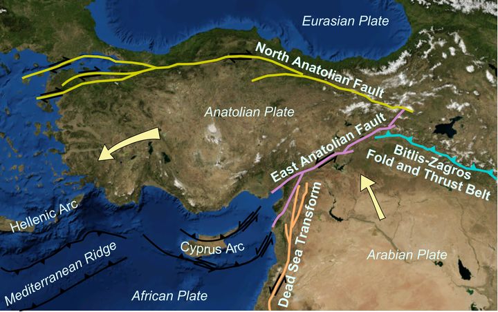
For Turkey, there has not been an earthquake of this size since Erzincan in 1939 when an Mw7.8 shake occurred at the eastern section of the east-west North Anatolian Fault – a fault which extends across 1,500 kilometers (932 miles) from the Aegean Sea and across northern Turkey. This fault separates the Anatolian Plate and the Eurasian Plate.
Figure 1: Map showing main tectonic structures around the Anatolian Plate on a base taken from a snapshot from Nasa's World Wind software. Arrows show displacement vectors of the Anatolian and Arabian Plates relative to the Eurasia Plate. Source: Wikimedia
The Mw7.6 İzmit earthquake in 1999 was also on the North Anatolian Fault, located at the western end to the southeast of İstanbul, and killed around 18.000 people.
But this current February 6, 2023, earthquake is located on the East Anatolian Fault plate boundary, a 700-kilometer (434 miles) boundary that runs northeast-southwest and separates the Anatolian Plate from the Arabian Plate.
The fault rupture for this latest earthquake in Turkey is likely to be around 200 kilometers long (124 miles), with strong vibrations radiated along its path. The pattern of significant aftershocks follows this fault for about 200 kilometers, extending as far as the coast around the Turkey/Syria border.
To give some perspective on this current event, the February 6, 2023, earthquake in eastern Turkey is of similar size to the 2008 Wenchuan Mw7.9 earthquake in China in which the fault rupture on the Longmenshan Fault, a thrust structure along the border of the Indo-Australian Plate and Eurasian Plate, was some 240 kilometers (149 miles) long. Over 87,000 people were killed.
Probability of Another Earthquake
This East Anatolian Fault plate boundary comprises a network of faults, and the probability remains high in the hours and days after this major earthquake that another major earthquake could be triggered.
We have already seen that within 12 hours of the original mainshock, a major Mw7.5 earthquake has broken another 100-kilometer (62 miles) long fault inland and to the north of the original shock.
There are also many aftershocks, spanning the full length of both fault ruptures. For such large earthquakes, it is misleading to focus on the location and depth of the epicenter which is simply where the rupture was initiated, often at one end of the fault rupture.
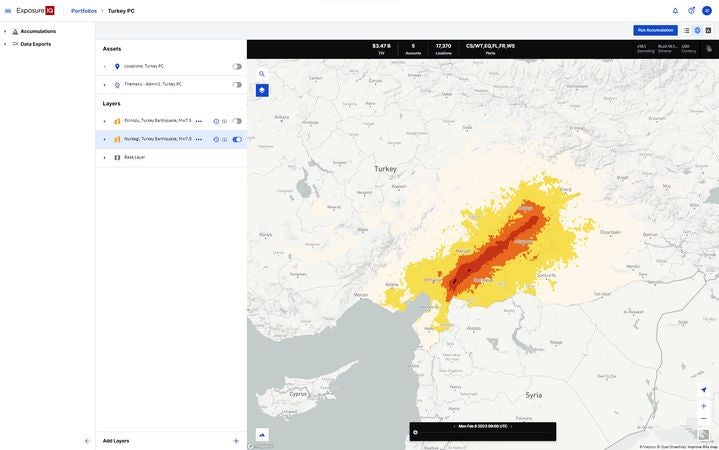
Figure 2: Moody's RMS Event Response accumulation layer on the ExposureIQ application. The screenshot shows an example of accumulated exposure for the first earthquake as reported by USGS over a detailed layer that classifies the affected area by MMI values.
The largest city in the path of the fault rupture is Gaziantep in southeastern Turkey, just 40 kilometers (25 miles) from the northern Syria border, with a population of 2.1 million – the sixth-most populous city in the country. Over 580 buildings have collapsed in Gaziantep Province, including large apartment blocks, and one hospital has partially collapsed.
The southwest end of the fault rupture is located around İskenderun, a Mediterranean coastal city some 115 kilometers (71 miles) west-southwest of Gaziantep and is close to the Roman city of Antioch (Antakya) – a city that has been destroyed by earthquakes several times in its history.
The northeast end of the fault rupture may extend to around Adıyaman, around 230 kilometers (143 miles) from Iskenderun. In Hatay Province, which includes Iskenderun, there has been widespread and severe damage to businesses and residential properties reported in İskenderun, and the city's hospital has partially collapsed.
From a comprehensive historical review of historical earthquakes in the region[1], earthquakes of this size are rare. Indeed, severe seismic ground motion from the February 6, 2023 earthquake was strong enough to cause the collapse of Gaziantep Castle, which was first used as an observation point during the Hittite Empire in the second millennium BC, and built as a Roman castle between the second and third centuries AD.
Building Resilience
A lot of the building stock across Turkey comprises 5-8 story apartment buildings, often constructed without an engineer or formal approval. Consequently, these buildings are not properly designed to resist strong earthquake shaking.
Using data from the Building Census report published in 2000, a recent 2021 study from the Middle East Technical University in Ankara[2] found that only 11 percent of the total building stock of 115,941 buildings in Gaziantep was fully compliant with the building codes.
As much as 38 percent of the total building stock in Gaziantep had no compliance with earthquake building codes. These figures may be representative of other smaller towns in the region, such as Kahramanmaraş and Malatya, which have suffered significant damage.
High levels of damage have extended to many other towns and cities including over the border into Kurdish Syria.
With the original earthquake striking at 4 a.m. when everyone is asleep in their apartments, this will mean very high casualties – in the many thousands, even ten thousand plus. After devastating tragedies such as this current earthquake, it reminds us that resilience is the main defense against such powerful seismic events.
Implementing and enforcing strong building codes and either retrofitting existing buildings or ensuring new builds conform, is a route to lessen the impact of any future earthquake.
Clients can access the latest reports on this event via Moody’s RMS Client Center, or keep up to date with the latest insights on RMS social channels on Twitter and LinkedIn.
[1] Ambraseys N.N., Melville C.P., Adams R.D. (1994) The seismicity of Egypt, Arabia and the Red Sea. Cambridge University Press.
[2] Kelam A.A. et al. (2022) An evaluation of seismic hazard and potential damage in Gazientep, Turkey. Soil Dynamics and Earthquake Engineering. 154.
Robert Muir-Wood works to enhance approaches to natural catastrophe modeling, identify models for new areas of risk, and explore expanded applications for catastrophe modeling. Robert has more than 25 years of experience developing probabilistic catastrophe models. He was lead author for the 2007 IPCC Fourth Assessment Report and 2011 IPCC Special Report on Extremes, and is Chair of the OECD panel on the Financial Consequences of Large Scale Catastrophes.
He is the author of seven books, most recently: ‘The Cure for Catastrophe: How we can Stop Manufacturing Natural Disasters’. He has also written numerous research papers and articles in scientific and industry publications as well as frequent blogs. He holds a degree in natural sciences and a PhD both from Cambridge University and is a Visiting Professor at the Institute for Risk and Disaster Reduction at University College London.
Gordon is a catastrophe-risk expert, with 30 years’ experience in catastrophe science, covering both natural and man-made hazards. Gordon is the chief architect of Moody's RMS terrorism risk model, which he started work on a year after joining RMS in December 2000. For his thought leadership in terrorism risk modeling, he was named by Treasury & Risk magazine as one of the 100 most influential people in finance in 2004. He has since lectured on terrorism at the NATO Center of Excellence for the Defense against Terrorism and testified before the U.S. Congress on terrorism-risk modeling.
As an acknowledged, international expert on catastrophes, Gordon is the author of two acclaimed books: “The Mathematics of Natural Catastrophes” (1999) and “Calculating Catastrophe” (2011). Dr. Woo graduated as the best mathematician of his year at Cambridge University and he completed his doctorate at MIT as a Kennedy Scholar and was a member of the Harvard Society of Fellows. He also has a Master of Science in computer science from Cambridge University.


