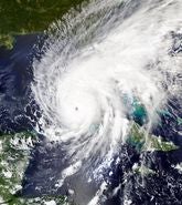
June 1 heralded the official start of the 2023 North Atlantic hurricane season and with Tropical Storm Arlene and Bret already on the board, and nine hurricane landfalls in the last three years including four at Category 3, 4, or 5 strength – there is one question on everybody’s mind. Will this hurricane season be as impactful and costly as 2020, 2021, and 2022?
Even though the 2022 North Atlantic hurricane season was classified as near normal in terms of its overall tropical activity, the insurance industry will remember the season for only one event: Hurricane Ian in late September 2022.
Ian was a historic and complex event that caused catastrophic wind and storm surge damage in southwest and central Florida and the Carolinas.
Landfalling as a Category 4 hurricane at Cayo Costa, Florida on September 28, and quickly moving across to the Gulf Coast resorts of Cape Coral/Fort Myers, Ian occurred in a precarious Florida insurance market amid rising inflation and is anticipated to be one of the costliest U.S. hurricanes on record.
Ian is an event that is set to reshape the Florida insurance market for years to come.
Looking at the current season, we have recently issued an executive summary of Moody’s RMS 2023 Northern Hemisphere Tropical Cyclone Outlook report, which includes a review of North Atlantic and Western North Pacific seasonal forecasts for this year and the key drivers of those forecasts.
Moody’s RMS customers can view the full thirty-page Outlook report via the Support Center.
North Atlantic Forecasts
The latest North Atlantic hurricane forecasts for 2023 indicate that a near-normal season is most likely, with an equal possibility of the season concluding above- or below normal.
The U.S. National Oceanic and Atmospheric Administration (NOAA) has forecast 12 to 17 named storms, of which 5 to 9 are expected to become hurricanes, and one to four of those are expected to become major hurricanes (Category 3 or stronger).
These predicted ranges are centered close to NOAA’s 1991–2020 U.S. Climate Normals seasonal average – 14 named storms, seven hurricanes, and three major hurricanes.
Outlooks from most of the other meteorological forecast agencies and groups are broadly in line with the guidance issued by NOAA in calling for a near-average season – with a few interesting exceptions, including the U.K. Met Office, which is anticipating a well above-average season.
If NOAA’s forecast verifies, then the 2023 North Atlantic hurricane season would be the second consecutive near-normal season; the last pair of near-normal seasons was 2006 and 2007.
Not all tropical cyclones make landfall, but long-term statistics indicate that the probability of a hurricane making landfall in the U.S. increases during more-active seasons.
Landfall forecasts from Colorado State University (CSU) anticipate a 43 percent probability of at least one major hurricane making landfall in the U.S. this season. Tropical Storm Risk (TSR) forecasts one hurricane and three tropical storms to make landfall over the contiguous U.S. in 2023.
It is also worth remembering that climatologically, tropical cyclone activity in the North Atlantic Basin peaks during the period between mid-August and late October. Some forecasting groups will issue a revised forecast in early August to reflect the increased certainty in the meteorological and oceanic variables.
So, what are the major factors driving hurricane risk for this season?
ENSO Versus SSTs
These forecasts of a near-normal hurricane season reflect the competing and opposing influence of several key seasonal oceanic and meteorological factors, primarily the El Niño-Southern Oscillation (ENSO) and sea surface temperatures (SSTs) in the tropical North Atlantic.
A large proportion of the uncertainty associated with seasonal hurricane activity forecasts can be attributed to the uncertainty about which ENSO phase will materialize during the peak months of the hurricane season.
For a more detailed explanation of ENSO, how it was discovered, and how it works, take a look at this Moody's RMS blog.
For 2023, El Niño conditions have emerged in recent months and are expected to persist through the hurricane season.
In the absence of influence from any other atmospheric or oceanic conditions and all other factors remaining equal, this would typically result in below-average tropical activity in the North Atlantic Basin owing to the increased wind shear that suppresses tropical activity.
However, sea surface temperatures in the North Atlantic, and in particular, in the Main Development Region, reached their warmest on record (since 1979) for the time of year in late May.
Models are forecasting above-average SSTs departures for the period covering the peak months of the hurricane season between August and October 2023. Warmer sea surface temperatures typically enhance tropical activity by providing increased energy and moisture to the environment.
These factors – with some that suppress storm development and some that fuel it – have resulted in the overall forecast for a near-normal season.
However, there remains a reasonable possibility that the season could conclude with below- or above-normal activity if one of these competing factors exhibits a greater influence over the season.
There are other factors, such as the North Atlantic Oscillation (NAO), the Madden-Julian Oscillation (MJO), and the Saharan Air Layer (SAL), that can influence tropical cyclone activity on a weekly or monthly basis but are difficult to forecast at seasonal timescales.
Western North Pacific Forecasts
How will El Niño conditions impact typhoon activity in the Western North Pacific? Forecasts again coalesce around a near-to-above-average year in the Western North Pacific Basin for 2023.
During El Niño years, the main cyclogenesis region shifts east, nearer the warmer waters of the equatorial Pacific Ocean, and weaker trade winds and increased atmospheric instability typically lead to increased overall activity for the basin. Sea surface temperatures across the Western North Pacific Basin are expected to be near or above average between July and November.
A Trusted Partner
It takes just one major event to turn a season – as we saw with Hurricane Ian last year. As a trusted partner, we continue to work diligently to build on our recent advancements and provide our clients with faster and more comprehensive analytics.
For instance, the ExposureIQ™ application on the Moody’s RMS Intelligent Risk Platform™ now puts Moody’s RMS Event Response and Moody’s RMS HWind insights in our clients’ hands like never before, with around-the-clock automated updates every few hours.
The Moody’s RMS Event Response team is ensuring Moody’s RMS clients are well informed of global tropical cyclone activity with regular updates for clients on the Support Center. Follow Moody’s RMS social media channels on Twitter and LinkedIn for updates.
Download the Moody’s RMS 2023 Northern Hemisphere Tropical Cyclone Outlook Executive Summary.


