We were not kept waiting long for a tropical system to take full advantage of the hurricane-promoting conditions on offer, with a major hurricane just four weeks into the season.
In fact, in our Moody’s 2024 Northern Hemisphere Tropical Cyclone Outlook published last month, we discussed how oceanic conditions in the North Atlantic were primed for storm activity, with both sea surface temperatures (SSTs) and oceanic heat content at or near record levels across much of the tropical North Atlantic and Caribbean Sea.
As always, Moody’s RMS Event Response team is ensuring clients are well informed of new developments on Beryl and their possible implications in terms of loss.
Beryl: Records Tumble
A low over the tropical North Atlantic in late June became Tropical Storm Beryl at 00:00 UTC on Saturday, June 29.
In just 48 hours, the system had taken advantage of the warmer-than-average SSTs and a favorable atmospheric environment, to rapidly intensify from a tropical depression to a Category 4 major hurricane, with its maximum sustained wind speeds increasing from 35 miles per hour (56 kilometers per hour) to 130 miles per hour (209 kilometers per hour).
An eyewall replacement cycle then temporarily weakened the system back to a Category 3 major hurricane but with a broadened hurricane-force wind field, it regained Category 4 major hurricane intensity on its final approach to the Caribbean Windward Islands.
At around 15:10 UTC (11:10 local time) on Monday, July 1, Hurricane Beryl made landfall as a Category 4 major hurricane over Grenada's Carriacou Island. At landfall, Beryl had maximum sustained wind speeds of 150 miles per hour (240 kilometers per hour) and a central pressure of 950 hPa.
This makes Beryl the strongest hurricane on record to impact the southernmost Caribbean Windward Islands.
Damage information from the Caribbean Windward Islands is still emerging, but catastrophic wind and storm surge damage is anticipated in areas affected by Beryl’s core and eyewall.
Pulling away from the Caribbean Lesser Antilles into the eastern Caribbean Sea, environmental conditions became even more favorable.
Beryl continued to intensify, eventually achieving Category 5 major hurricane intensity at 00:00 UTC on Tuesday, July 2, the earliest Category 5 major hurricane on record to occur in the North Atlantic Basin.
It is only the second reported Category 5 major hurricane on record in July; the previous earliest (and only other Category 5 major hurricane in July) was Hurricane Emily on July 17, 2005.
Beryl has already achieved numerous North Atlantic Basin records, including:
- Easternmost hurricane to form in June
- First tropical cyclone to undergo rapid intensification in the main development region in June
- Earliest rapid intensification from a tropical depression to a major hurricane
- Strongest hurricane in June
- Earliest Category 4 hurricane
- Southernmost Category 4 hurricane
- Strongest hurricane to impact the southernmost Caribbean Windward Islands
- Earliest Category 5 hurricane
Responding to Beryl
Moody’s RMS Event Response is actively supporting its clients to respond to Beryl via the release of event summaries and accumulation and modeling information on the Support Center.
The Moody’s RMS North Atlantic Hurricane catastrophe risk models, and accompanying event response tools, including HWind data, allow customers to account for direct physical wind and storm surge damage to properties.
The stochastic event selections Moody’s RMS Event Response provides to clients aim to provide context on the range of possible scenarios based on the National Hurricane Center (NHC) forecast and model guidance, highlighting the efficacy of the model to capture the location, magnitude, extent, and severity of even a rare Category 5 hurricane as Beryl.
Additionally, customers using the ExposureIQ application on Moody’s Intelligent Risk Platform can take advantage of frequently released detailed accumulation layers available directly in the application.
Moody’s HWind licensed clients also receive updated forecasts of industry losses four times daily, automatically delivered to their inboxes.
HWind Analysis
Moody’s HWind has issued regular real-time wind footprint snapshots and forecasts for Moody’s HWind licensed clients since Beryl’s formation last week.
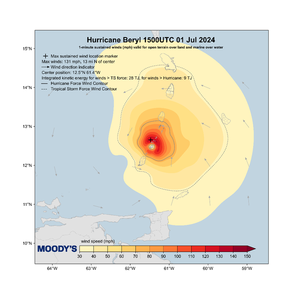
The figure below shows a wind field snapshot from 15:00 UTC on Monday, July 1 when the center of Beryl crossed the Caribbean Windward Islands.

Examining the wind field snapshot in more detail, Beryl’s maximum sustained wind speeds at landfall were estimated to be 131 miles per hour (210 kilometers per hour), and its wind field was calculated to have approximately 47 terajoules of integrated kinetic energy (IKE).
Forecast: Jamaica, Cayman Islands, and Mexico in Beryl’s Sight
Environmental conditions over the central Caribbean Sea are now more hostile and less conducive, as moderate-to-high vertical wind shear is expected to see Beryl weakening gradually over the coming few days.
Nevertheless, Beryl is expected to remain a powerful major hurricane as it moves into the central Caribbean Sea.
It is currently expected to pass very near or over Jamaica on Wednesday, July 3 as a Category 4 major hurricane and then near the Cayman Islands overnight into Thursday, July 4 as a Category 3 major hurricane.
A more northerly track could bring hurricane-force winds to a much broader area of Jamaica, and the center of Beryl could potentially make a direct landfall on its southern coastline.
Its path near or over Jamaica will ultimately determine the extent of impacts in the Cayman Islands.
A more southerly track, combined with expected weakening from dry air intrusion and possible interaction with Jamaica’s elevated terrain, would result in fewer impacts, while a more northerly track could bring hurricane conditions closer to the islands.
Later this week, conditions over the northwestern Caribbean Sea appear somewhat more favorable. The operational forecast models show quite a wide range of potential outcomes for Beryl’s intensity on its approach to Mexico’s Yucatán Peninsula, with guidance ranging from a strong tropical storm to a major hurricane.
The current NHC forecast calls for Beryl to be near the west coast of the Yucatán Peninsula as a Category 2 hurricane.
Whatever is left of Beryl after it crosses the Yucatán is expected to emerge over the southern Gulf of Mexico on Saturday, July 6. Current guidance indicates Beryl will be a tropical storm at this point, but the intensity forecasts beyond Saturday remain highly uncertain.
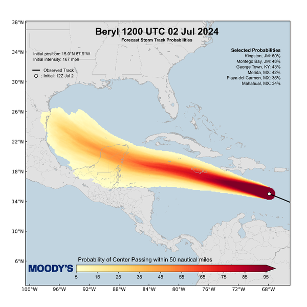
Moody’s HWind has issued regular forecasting files for Beryl for Moody’s HWind licensed clients since its formation.
A recent forecast storm track probabilities map is shown below, illustrating the likelihood of the system's center passing within 50 nautical miles of a given location.

Follow our social media channels on X/Twitter and LinkedIn for updates.


