logo image

Insurance Solutions

Formerly Moody’s RMS

Which of the following would you say has the shortest odds?

a) Someone getting injured by a firework
b) A meteor landing on a house
c) Someone being struck by lightening
d) A tsunami striking east coast of Japan
e) A person being on a plane with a drunken pilot

Disturbingly option e) has the shortest odds at 117 to 1 but you may be surprised to hear that option d) is next, the earthquake that led to the 2011 Japan tsunami had an annual probability of approximately 600 to 1 (other odds; a. 19.5K to 1; b. 182T to 1; c. 576K to 1).

Tsunamis can be devastating when they occur, as we saw when the Indian Ocean tsunami hit in 2004 and more recently with the Tohoku, Japan tsunami in 2011. But before these events, tsunami risk wasn’t high on many (re)insurers agendas.

It’s one of those risks that many would place in the upper left green section of the frequency / severity risk map below, requiring periodic attention.
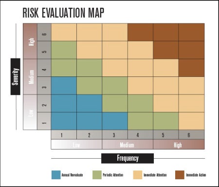
risk map

The first step in managing risk is to identify and categorize it.

Some other natural catastrophe risks, such as earthquake, fall near this region but generally garner immediate attention. So what made tsunami different?

Tsunamis have a particularly low frequency, especially when only considering events that have impacted developed regions. In addition, limited data availability and complexities associated with modeling this hazard meant that it was a risk that the industry was aware of but didn’t necessarily evaluate.

The lack of data was highlighted by the Tohoku event. An earthquake of the magnitude observed was not anticipated for the subduction zone off the east coast of Japan. The maximum projected earthquake magnitude was 8.3, with accompanying expected tsunami heights not as large as those experienced. Sea walls built along northeast Japan’s coastal towns, such as in Minamisanriku, Miyagi, weren’t designed to protect against the tsunami that occurred.

This devastating event brought tsunami risk into sharp focus but the questions we must now ask are:

  • Where will the next tsunami-generating great earthquake be?
  • How can we manage this risk?

An interesting conundrum surrounding the first question is the number of very large earthquakes that we have observed recently.

Before the 2004 Indian Ocean tsunami, the last earthquake greater than magnitude 8.6 occurred 40 years earlier (1965’s Mw 8.7 Rat Islands, Alaska Earthquake). However, since 2004 we have observed 5 earthquakes equal to or greater than Mw 8.6. It’s unclear whether we have underestimated the potential for large earthquakes or are just observing a random clustering of large events.

As research continues into the frequency and occurrence of these events, perhaps the best approach is to focus on understanding hazard hot spots. Most devastating tsunamis are generated by earthquakes in subduction zones and incidentally, subduction zones are where most great earthquakes (Mw 8.7+) have been observed.

Since 1900 all observed great earthquakes were generated on shallow subduction zone “megathrust” faults. Therefore it is vital to understand where these earthquakes occur and the potential associated tsunami scenarios.

Looking back to our risk map, risks with this frequency / severity combination may not stop (re)insurers providing cover. However, assessing scenarios will help them understand their tail risk and manage potential accumulations, which may lead to stricter underwriting guidelines and policy terms in high-risk zones.

Typhoon Haiyan recently highlighted the devastation caused by coastal inundation. On this occasion from storm surge, yet the city of Tacloban is vulnerable to tsunamis of greater height, as noted by Robert Muir-Wood in his recent post.

November 25th marked the 180th anniversary of another great earthquake to strike the region of Sumatra, Indonesia; the 1833 event occurred just south of the location of the devastating 2004 earthquake and also caused a significant tsunami.

These events remind us that while tsunami may be an infrequent hazard, coastal inundation can be devastating and these events have occurred in the past and will occur again in the future.

Although the industry may not know when the next event will occur, tools like accumulation scenarios can help (re)insurers explore the risk, understand where their exposure to tsunami is greatest and evaluate how to best to manage it.

Share:
You May Also Like
January 15, 2015
Lessons Hidden In A Quiet Windstorm Season

Wind gusts in excess of 100mph hit remote parts of Scotland earlier this month as a strong jet stream brought windstorms Elon and Felix to Europe. The storms are some of the strongest so far this winter; however, widespread severe damage is not expected because the winds struck mainly remote areas. These storms are characteristic of what has largely been an unspectacular 2014/15 Europe windstorm season. In fact the most chaotic thing to cross the North Atlantic this winter and impact our shores has probably been the Black Friday sales. This absence of a significantly damaging windstorm in Europe follows on from what was an active winter in 2013/14, but which contained no individual standout events. More detail of the characteristics of that season are outlined in RMS’ 2013-2014 Winter Storms in Europe report. There’s a temptation to say there is nothing to learn from this year’s winter storm season. Look closer, however, and there are lessons that can help the industry prepare for more extreme seasons. What have we learnt? This season was unusual in that a series of wind, flood, and surge events accumulated to drive losses. This contrasts to previous seasons when losses have generally been dominated by a single peril—either a knockout windstorm or inland flood. This combination of loss drivers poses a challenge for the (re)insurance industry, as it can be difficult to break out the source of claims and distinguish wind from flood losses, which can complicate claim payments, particularly if flood is excluded or sub-limited. The clustering of heavy rainfall that led to persistent flooding put a focus on the terms and conditions of reinsurance contracts, in particular the hours clause: the time period over which losses can be counted as a single event. The season also brought home the challenges of understanding loss correlation across perils, as well as the need to have high-resolution inland flood modeling tools. (Re)insurers need to understand flood risk consistently at a high resolution across Europe, while understanding loss correlation across river basins and the impact of flood specific financial terms, such as the hours clause. Unremarkable as it was, the season has highlighted many challenges that the industry needs to be able to evaluate before the next “extreme” season comes our way.…

November 04, 2014
What to expect this 2014-2015 Europe Winter Windstorm Season

When it rains in Sulawesi it blows a gale in Surrey, some 12,000 miles away? While these occurrences may sound distinct and uncorrelated, the wet weather in Indonesia is likely to have played some role in the persistent stormy weather experienced across northern Europe last winter. Weather events are clearly connected in different parts of the world. The events of last winter are discussed in RMS’ 2013-2014 Winter Storms in Europe report, which provides an in-depth analysis of the main 2013-2014 winter storm events and why it is difficult to predict European windstorm hazard due to many factors, including the influence of distant climate anomalies from across the globe. Can we predict seasonal windstorm activity during the 2014-2015 Europe winter windstorm season? As we enter the 2014-2015 Europe winter windstorm season, (re)insurers are wondering what to expect. Many consider current weather forecasting tools beyond a week to be as useful as the unique “weather forecasting stone” that I came across on a recent vacation. I am not so cynical; while weather forecasting models may have missed storms in the past and the outputs of long-range forecasts still contain uncertainty, they have progressed significantly in recent years. In addition, our understanding of climatic drivers that strongly influence our weather, such as the North Atlantic Oscillation (NAO), El Niño Southern Oscillation (ENSO), and the Quasi-Biennial Oscillation (QBO) is constantly improving. As we learn more about these phenomena, forecasts will improve, as will our ability to identify trends and likely outcomes. What can we expect this season? The Indian dipole is an oscillation in sea surface temperatures between the East and West Indian Ocean. It has trended positively since the beginning of the year to a neutral phase and is forecast to remain neutral into 2015. Indonesia is historically wet during a negative phase, so we are unlikely to observe the same pattern that was characteristic of winter 2013-2014. Current forecasts indicate that we will observe a weak central El Niño this winter. Historically speaking this has led to colder winter temperatures over northern Europe, with a blocking system drawing cooler temperatures from the north and northeast. The influence of ENSO on the jet stream is less well-defined but potentially indicates that storms will be steered along a more southerly track. Lastly, the QBO is currently in a strong easterly phase, which tends to weaken the polar vortex as well as westerlies over the Atlantic. Big losses can occur during low-activity seasons Climatic features like NAO, ENSO, and QBO are indicators of potential trends in activity. While they provide some insight, (re)insurers are unlikely to use them to inform their underwriting strategy. And, knowing that a season may have low overall winter storm activity does not remove the risk of having a significant windstorm event. For example, Windstorm Klaus occurred during a period of low winter storm activity in 2009 and devastated large parts of southern Europe, causing $3.4 billion in insured losses. Given this uncertainty around what could occur, catastrophe models remain the best tool available for the (re)insurance industry to evaluate risk and prepare for potential impacts. While they don’t aim to forecast exactly what will happen this winter, they help us understand potential worst-case scenarios, and inform appropriate strategies to manage the exposure.…

Adrian Mark
Adrian Mark
Senior Manager, Model Product Strategy, RMS

As a member of RMS' model solutions team, Adrian works to guide more informed usage of catastrophe models and enhance understanding of model uncertainty. This requires interaction with the market, as well as other important stakeholders such as regulators and rating agencies, to help RMS develop tools that capture the evolving needs of the risk management industry. Based in London, his primary focus is on supporting the RMS European modeling suite. Adrian holds a BS in meteorology and oceanography from the University of East Anglia and an MS in engineering in the coastal environment from the University of Southampton.

cta image

Need Help Managing Your Portfolio?

close button
Overlay Image
Video Title

Thank You

You’ll be contacted by an Moody's RMS specialist shortly.