Super Typhoon Mangkhut (26W) — the twenty-fourth named storm in the western North Pacific this year, was tracking over open ocean around 321 miles (516 kilometers) east-northeast of Manila, Philippines at 0000 UTC Friday, September 14. Mangkhut, named as Ompong in the Philippines using the Philippine Atmospheric, Geophysical and Astronomical Services Administration (PAGASA) naming system, is the first storm of typhoon strength to impact the Philippines since Typhoon Nock-ten on December 25, 2016, after 2017 proved relatively quiet, typhoon-free year for the country.
With the Philippines currently in the monsoon season (south west monsoon), which brings rain to western parts of the country, Typhoon Mangkhut is enhancing this monsoon system (termed as a “Hanging Habagat” locally) to bring heavier rains to the western side of the Philippines including Palawan, the Visayas, and northern Mindanao. Mangkhut is the strongest storm of the year so far — currently a category 5 equivalent storm (on the Saffir Simpson Hurricane Wind Scale — SSHWS) with 1-minute sustained winds of 166 miles per hour (267 kilometers per hour) as reported by the Joint Typhoon Warning Center (JTWC).
This typhoon has travelled far; it passed Guam — around 1500 miles or 2414 kilometers east of the Philippines on Monday, September 10. The center of Mangkhut tracked over Rota Island, bypassing approximately 40 miles (65 kilometers) to the north of Guam at around 0800 UTC. Hurricane-force gusts of up to 80 miles per hour (128 kilometers per hour) were observed on the island. The U.S. island territory of Guam avoided major damage, although a number of homes had flooded, and local reports stated that on Tuesday, September 11, eighty percent of the island — with a population of around 162,000, was without power.
Leaving Guam
The storm has intensified considerably since moving away from Guam, with high along-track sea surface temperatures and ocean heat content conducive for Mangkhut’s recent intensification.
According to the Japan Metrological Agency, PAGASA, and JTWC forecast guidance, Mangkhut is currently forecast to track west-northwestwards, maintaining its current intensity, equivalent to at least a Category 4 hurricane on the SSHWS. It will pass across the northern Philippines and is expected to make landfall in the northern Cagayan, Luzon, shortly after 1800 UTC on Friday, September 14.
Northern Luzon is a relatively rural and sparsely populated area of the Philippines, so while damage to property, infrastructure, and agriculture in the areas affected may be significant, the total economic and insured losses are likely to be limited. The Philippines has been preparing in advance of the storm, and the local agency PAGASA has issued several tropical storm warnings; they are warning of sustained winds of 127 miles per hour (205 kilometers per hour), with gusts up to 158 miles per hour (255 kilometers per hour), and potential storm surges of 6 meters (19 feet) in northeastern Luzon.
The Philippines is used to strong typhoon impacts, most notably Typhoon Haiyan (Yolanda), which caused widespread damage in the Visayas Islands in 2013. Strong winds and heavy rain may affect areas some distance from the storm center, including Manila in the Philippines, and although Mangkhut is quite far south of Taiwan, it may still cause heavy rainfall in southern Taiwan.
Passage to the Pearl River Delta
Following landfall in the Philippines, the system is expected to track over Luzon before re-emerging over the South China Sea. Mangkhut is likely to weaken slightly after leaving the Philippines over the next few days before potentially impacting southern China and Hong Kong. There is a 40 to 50 percent chance of tracking within 75 miles (120 kilometers) of Hong Kong, which will fall within the radius of hurricane force winds, although there is still considerable uncertainty in the track at this stage. Southern China and Hong Kong are likely to be at risk from all these perils; wind, storm surge and flood from Mangkhut — building codes are quite stringent in this area to withstand strong winds, but it is more difficult to mitigate against flooding and surge.
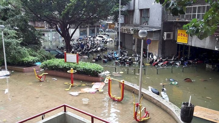
Street flooding in Freguesia de Nossa Senhora de Fátima, Macau, during Typhoon Hato, August 23, 2017. Image credit: Wikipedia/JyanWaan
The Pearl River Delta, which includes Hong Kong and Macau, is one of the most densely populated parts of China and represents a sizeable accumulation of exposure at risk if the storm forecast holds— with insurance penetration in Hong Kong also relatively high compared to the Philippines, and the rest of China. Hong Kong, Macau and southern China have recent experience of a strong typhoon landfall, with Typhoon Hato impacting the area in August 2017 and causing significant damage — however Hato strengthened rapidly just prior to landfall meaning there was little time to prepare, whereas people will be well aware of the approach and potential dangers of Mangkhut, which is likely to impact the area on Sunday, September 16.
Macau was severely impacted by Typhoon Hato last year, and there have been efforts made to improve resiliency to storms, but Mangkhut will come too soon for many of the projects to have been completed. However, the local government have improved their communication and preparedness this time round.
RMS is proud of the investment it has made in modeling these events, with its models covering the region, and the recently released RMS Philippines Typhoon and Inland Flood Model includes the typhoon perils of wind, typhoon-driven inland flooding, and storm surge. It is also the only Philippines model to include non-tropical cyclone rainfall driven flooding, including seasonal and monsoon rain-driven flooding. The RMS Taiwan Typhoon Model includes bypassing events to capture the rainfall and flood risk from storms such as Mangkhut, and the RMS China and Hong Kong Typhoon Model also captures the risk from wind, typhoon-driven flooding, and storm surge.
Please follow RMS on Twitter, LinkedIn and visit the RMS blog as we provide more updates on the progress and impact of Mangkhut.
Share:
You May Also Like
May 04, 2021
RMS Models Offer New Probabilistic Approach to Simplify Flood Management Across Southeast Asia
Based in London, Simon joined RMS in 2012 and works within the Product Management team, focusing on the Asia-Pacific climate suite of products. He is product manager for the RMS typhoon models for China, Taiwan, South Korea, the Philippines, and Guam, and has most recently been involved in supporting the development of new inland flood models for China and Southeast Asia.
Simon holds a bachelor's degree in Geography from the University of Nottingham and a master's degree in Geological and Environmental Hazards from the University of Portsmouth.