From first light yesterday (October 11), the full extent of the damage from Major Hurricane Michael across the Florida Panhandle and the wider region became clear — and it really was as catastrophic as we all had feared.
Although Major Hurricane Michael could be regarded as a more traditional “wind and surge” event compared to recent flood events of hurricanes Harvey and Florence, this was not just a coastal event. The trail of destruction extends far from the landfall location near Mexico Beach (pop. ~1,000) and neighboring Panama City (pop. ~36,000) and well into the state of Georgia. Whether it is from the destruction of homes in the towns near landfall, or the widespread power outages, felled trees, damaged roofs, and debris, the clean-up operation is going to be a long process. And tragically, as of Friday, October 12, eight fatalities have been confirmed, including four in Florida, one in Georgia, and one in North Carolina.
Mexico Beach and Panama City
These two Florida coastal towns suffered the brunt of the wind and storm surge damage, as well as Port St. Joe (pop. ~3,500), 10 miles (16 kilometers) southeast along the coast from Mexico Beach. The National Hurricane Center (NHC) recorded peak storm surge inundation of 9 to 14 feet (2.7 to 4.3 meters) from Mexico Beach eastward through to Apalachee Bay, with the highest values estimated near Mexico Beach and Port St. Joe.
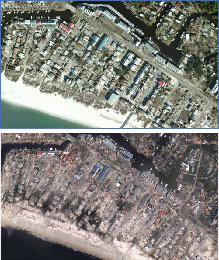
For the small town of Mexico Beach, aerial footage shows extensive damage to almost every structure, and a large percentage of homes have been removed from their slabs or destroyed. An entire neighborhood between 40th and 42nd Street, close to marina and city pier, has been leveled. Some homes have been transported several hundred feet from their locations, and any structures still standing have sustained considerable damage.
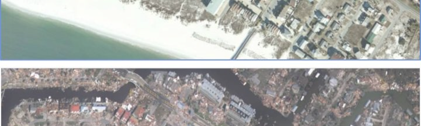
Satellite imagery of Mexico Beach, Florida, top image shows the area before Major Hurricane Michael, lower image shows impact after the hurricane. Image source: NOAA
In the larger neighboring town of Panama City, just ten miles (16 kilometers) northwest up the coast from Mexico Beach, major wind damage is reported to all building types, including residential, light commercial, warehouse, offices, and high-rise buildings.
Dozens of buildings have experienced complete structural failure; many other homes have lost their roofs, and downed trees and power lines have severely damaged many others. In the downtown area of Panama City, catastrophic damage is reported, including the Bay Medical Center hospital complex. Every mobile home in Panama City has either been destroyed or severely damaged, according to local authorities and local television news reports.
Tyndall Air Force Base
Wind speeds of 129 miles per hour (208 kilometers per hour) were recorded at the Tyndall Air Force Base, across the East Bay from Panama City. According to officials, Michael caused “catastrophic damage” to almost every structure. Colonel. Brian S. Laidlaw, Commander of the 325th Fighter Wing division based at Tyndall stated the site “…requires extensive clean-up and repairs.” Its fleet of fifty-five F-22A Raptor fighters, and seventeen trainer jets had been previously flown out to other airbases as a precaution, though aircraft remaining in hangers were damaged or destroyed. Every building at the site is severely damaged, with many flattened.
For nearby Port St. Joe, the Mayor has estimated that at least 1,000 homes have been completely or partially destroyed. Much of downtown Port St. Joe was flooded by storm surge, which reportedly carried a large ship onto the shore, and dozens of boats are damaged in the Port St. Joe marina.
Florida’s state capital, Tallahassee, saw downed trees and power lines that have caused damage to properties and city-wide power outages. Local media report that over 200 roads in the city are blocked by fallen trees, but there are no significant reports of wind damage other than tree falls.
Georgia, The Carolinas, and Virginia
Georgia experienced Category 3 wind speeds from Michael with 115 miles per hour (185 kilometers per hour) reported in Donalsonville, and 70 miles per hour (113 kilometers per hour) in Albany. A number of reports state that trees and power lines have been toppled under high winds across the cities of Augusta (pop. ~600,000) and Macon (pop. ~93,000). For North Carolina, rainfall accumulations of up to 7 inches (178 millimeters) in some areas led to flash flooding, with Charlotte (pop. ~842,000) and Raleigh (pop. ~459,000), affected by street flooding.
In the city of Columbia (pop. ~134,000), South Carolina, there are reports of trees having toppled under high winds, causing significant damage to several properties. For Virginia, heavy rainfall associated with the passing of then-Tropical Storm Michael caused flash flooding through parts of the Roanoke Valley.
Adding to the tally of damages, the U.S. Agriculture Department has reported that Michael severely damaged cotton, timber, pecan, and peanut crops, affecting up to 3.7 million crop acres (1.5 million hectares) and causing estimated liabilities as high as US$1.9 billion. Michael also disrupted energy operations in the Gulf of Mexico prior to landfall, cutting crude oil production by more than 40 percent and natural gas output by nearly a third.
As more detail on this event emerges, RMS will continue to provide clients with Event Response services via RMS OWL, and please follow RMS on Twitter, LinkedIn, Facebook and visit the RMS blog for updates.
Based in London, James is an Assistant Director within Moody's RMS Event Response team, supporting real-time event response operations and assisting on various event response projects. James holds a bachelor’s degree in Physical Geography and Geology from the University of Southampton and a master’s degree in Applied Meteorology from the University of Reading.