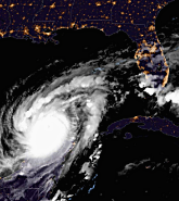
Fifty-four of the 67 counties in Florida are now under a State of Emergency declaration in preparation for Major Hurricane Milton, which formed on Saturday, October 5, and rapidly intensified into a Category 5 major hurricane over the southwestern Gulf of Mexico, although in a National Hurricane Center update at 0900 UTC Tuesday, October 8, Milton had eased to just under Category 5 strength.
But, all eyes are set on Milton's arrival on the west coast of Florida by mid-week.
It is clear that this will be a major storm with long-lasting impacts as evidenced by the numerous warnings and public statements from U.S. and Florida leaders:
Florida Governor Ron DeSantis gave a stark warning, stating that “… Floridians should prepare for more power outages and disruptions, making sure they have a week's worth of food and water and were ready to hit the road.”
Kevin Guthrie, executive director of the Florida Division of Emergency Management told CBS News, "I highly encourage you to evacuate and if you're in an evacuation zone, we are preparing ... for the largest evacuation that we have seen, most likely since 2017, Hurricane Irma."
With potentially less than 48 hours until Milton’s landfall, evacuation orders must be taken seriously to avoid loss of life.
For Irma, seven million residents evacuated. Shelters are now opening, and for those in vulnerable West Coast communities, especially those living in mobile homes/RVs, vital evacuations are well underway.
Florida residents are taking heed of the warnings and leaving their homes, with tailbacks on the highways heading north. Evacuations of hospitals, nursing homes, and assisted living facilities are underway, affecting over 6,600 patients, and schools are set to close this week. Six major airports have announced travel advisories.
Milton comes less than two weeks after Major Hurricane Helene made landfall as a Category 4 major hurricane in Florida’s Big Bend region near Perry, Taylor County, on September 26.
Helene was a powerful and broad storm (within the 90th percentile in terms of size, according to the NHC), delivering damaging winds and storm surge to coastal areas and then continued to generate wind damage and trigger significant flooding well into Georgia, Tennessee, and the Carolinas.
Some of the same areas impacted by Helene will also be impacted by Milton. Residents who just returned to their homes on Florida's West Coast after Helene are now under evacuation orders again for Milton.
With hurricane storm watches currently in place for Mexico’s Yucatan Peninsula, Hurricane Milton is forecast to track east and then northeast across the southern and eastern Gulf of Mexico over the coming days, passing near the northern coast of Mexico’s Yucatan Peninsula and then towards Florida by mid-week.
Milton is expected to encounter strong vertical wind shear and dry air entrainment on its approach to the Florida Gulf Coast and is expected to weaken slightly as it nears landfall, but is it still currently forecast to make landfall as a powerful Category 3 major hurricane on the west coast of Florida late local time on Wednesday, October 9. The exact timing, location, and intensity at landfall remains uncertain.
Damaging hurricane-force winds are expected to impact the west coast of Florida near where the center makes landfall and crosses the Peninsula, and a life-threatening storm surge could occur along portions of the west coast of the Florida Peninsula, especially in areas to the south of the where the center makes landfall.
Debris and damaged structures from Helene, and clear-up operations will be vulnerable.
As the southern U.S. looked to dry out after the immense levels of rainfall from Helene, heavy rainfall is already occurring across portions of the Florida Peninsula and the Florida Keys, which could cause considerable flash, urban, and areal flooding, and moderate to major river flooding.
Insurers must prepare for the prospect of significant damage from Milton, in a region that is no stranger to major tropical cyclones.
Since category 4 strength Hurricane Ian in September 2022, there have been six; with Hurricane Nicole in November 2022, Tropical Storm Arlene in June 2023, Hurricane Lee in September 2023, and Florida’s Big Bend region seeing three events in just 13 months, including Idalia in September 2023, and Debby in August and Helene in September this year.
Moody’s RMS Event Response is ready to assist clients and the wider insurance market in making sense of what will unfold over the next few days.
This includes event updates, accumulation information, similar stochastic events, and HWind footprints, including our new HWind forecasting footprints on Risk Modeler.
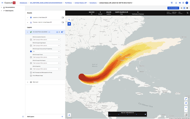
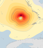
Moody’s HWind started issuing footprints, snapshots, and forecasts on Saturday, October 5. The latest HWind forecast track probability places central Florida locations in the highest risk area.
Figure 1: ExposureIQ forecast snapshot for Major Hurricane Milton
Clients using ExposureIQ on the Intelligent Risk Platform can already use the latest HWind insights directly into their exposure management. As always Event Response will provide potential tracks, footprints, accumulation data as well as regular updates.
Sarah leads the Moody’s RMS Event Response team, which is responsible for providing real-time guidance and modeling products across a wide breadth of global natural catastrophes.
She has a master’s degree in Applied Meteorology from the University of Reading.
Based in London, James is an Assistant Director within Moody's RMS Event Response team, supporting real-time event response operations and assisting on various event response projects. James holds a bachelor’s degree in Physical Geography and Geology from the University of Southampton and a master’s degree in Applied Meteorology from the University of Reading.