Hurricane Milton - over 40 blog update posts covering Milton from its development, landfall, and post-event analysis.
Moody's RMS Event ResponseOctober 24, 2024
The live blog has now ended. Thank you for reading the Hurricane Milton live blog from our Moody's RMS Event Response team and a range of Moody's experts across the business.
Keep checking back on the Moody's - Insurance Solutions blogs for the latest insights.
Thursday, October 24: 16:15 UTC
With discussions regarding the exact location of the peak surface winds at the time of Hurricane Milton’s landfall just after 0000 UTC on Thursday, October 10, in a new blog Jeff Waters, CCRA, CCRMP has examined the data behind the Moody's RMS HWind output for Milton.
Moody’s RMS HWind snapshots, including those for Hurricane Milton, are informed by observational data across over 30 sources, and Jeff goes into detail around the specifics of various wind field solutions and their peak surface wind observations, and the approach taken by HWind.
The private market U.S. insured loss estimate for Hurricane Milton was published yesterday (October 17) by Moody's RMS Event Response, with an estimate to be between US$22 billion and US$36 billion, with a best estimate of US$26 billion.
This estimate represents insured losses associated with wind, storm surge, and precipitation-induced flooding from the event. If you'd like to read the full announcement, please click here.
With leading insurance publications assessing the loss estimate, the Insurance Journal commented that the estimated range from Moody’s RMS could also put Milton in the top 10 costliest hurricanes to the insurance industry, albeit at the lower half of the table.
To read the Insurance Journal news article, please click here:
Thursday, October 17: 16:30 UTC
An estimate of private market U.S. insured losses for Hurricane Milton has just been published by Moody's RMS Event Response, with a estimate to be between US$22 billion and US$36 billion, with a best estimate of US$26 billion. The estimate represents insured losses associated with wind, storm surge, and precipitation-induced flooding from the event.
In the announcement, Mohsen Rahnama, Chief Risk Modeling Officer, Moody’s, commented:
“We were fortunate to avoid the ‘grey swan’ event that many feared when Milton tracked and made landfall south of the Tampa-St. Petersburg metro area. Still, the storm’s large swath of damaging winds, subsequent storm surge, and inland flood footprints affected key exposure areas throughout the state, which will undoubtedly make it one of the costliest hurricanes to impact west Florida."
For the loss estimate, Moody’s RMS Event Response had developed and validated the wind, storm surge, and inland flood reconstructions and corresponding loss estimates using proprietary and publicly available data, including wind station observations, river gauge water level data, web reconnaissance, aerial imagery analysis, and Moody’s RMS HWind real-time data products.
Also informing this analysis, as mentioned in the Milton Live Blog yesterday, Moody’s RMS conducted detailed field reconnaissance for this event, with a team of experts on the ground surveying the most impacted areas across Florida, spanning more than 1,300 miles.
Field reconnaissance confirmed numerous instances of improved resilience of structures that had their roofs replaced recently, and also highlighted areas with older building stock and roofs in parts of Tampa Bay that had not experienced such high winds in recent times, which will likely drive notable wind claims in Milton, especially if they are still subject to the Florida '25 percent' roof replacement rule.
Raj Vojjala, Managing Director, Modeling and Analytics, Moody’s, remarked that it was important to not just consider the overlap across areas affected by high winds and surge in Milton and Helene, but past events as well:
There are also areas that sustained damage during Hurricane Ian in 2022 that haven’t fully recovered yet. With our vulnerability experts on the ground surveying these impacts firsthand, this was invaluable in discerning the loss potential from Milton.
Alongside the damaging wind, storm surge, and precipitation-induced inland flooding from Milton, the outer rainbands of Hurricane Milton also produced numerous damaging tornadoes across Florida.
With damage surveys by the National Weather Service still being conducted, the confirmed data to date suggests that Milton produced one of the most prolific tornado outbreaks associated with a tropical cyclone in recent history.
Jeff Waters, Director - North Atlantic Hurricane Models, Moody’s, commented:
Moody’s RMS Event Response used insights from our own in-person reconnaissance and remote sensing data to analyze these tornado tracks and associated wind speeds. This data is incorporated into our wind reconstructions and overall industry loss estimate for Milton.”
Clients can access more post-event analysis on Hurricane Milton from the Support Center.
Wednesday, October 16: 17:00 UTC
With an initial combined U.S private insurance market loss estimate for Hurricanes Helene and Milton released earlier this week, and a standalone loss estimate for Hurricane Milton due for release, Mohsen Rahnama, Chief Risk Modeling Officer, at Moody’s, gave some insight into what's involved when we construct a insured loss estimate.
Commenting on the combined loss estimate earlier this week, Mohsen said:
“... our loss estimate is informed by Moody’s RMS Event Response’s rigorous approach to event insured loss estimation and includes a combination of observational data, detailed field reconnaissance so far spanning more than 2,000 miles, and aerial imagery analyses from both storms in the affected region.
Our reconnaissance teams are in Florida right now, and continue to survey the impacted areas. Estimating losses in these events is challenging and it is important to consider all associated complexities and uncertainties, especially in the overlapping regions affected by both hurricanes.”
At major natural catastrophe events, our on-the-ground Moody's RMS reconnaissance team of experts visit the impacted area to see for themselves the damage that a hurricane such as Milton can cause, getting clues on building performance, flood extents, the resilience of infrastructure and utilities, to help fine tune our modeling and event response to the actual picture on the ground.
The reconnaissance team has been across Florida since last weekend, examining different areas and establishing how each area, and different structures responded to the hurricane's impact, in terms of structure damage, potential rebuild costs and time, business interruption etc.
Thanks to Derek Stedman for sharing the picture above of our reconnaissance team examining damage to properties in Holmes Beach, Florida, a barrier island on the mouth of Tampa Bay, some 20 miles (32 kilometers) north-northwest of the location of Milton's landfall near Siesta Bay.
Clients can access more post-event analysis on Hurricane Milton from the Support Center.
Wednesday, October 16: 16:30 UTC
In the latest Moody's RMS Event Response update for Hurricane Milton, clients can now get information on 25 tornadoes that happened in Florida on Wednesday, October 9. On that day, National Weather Service (NWS) offices in Florida issued 126 tornado warnings - the most tornado warnings issued in Florida on a single day on record.
This figure represents the second-highest number of tornado warnings issued in a single state on a single day anywhere in the U.S. on record, trailing only the 2011 Super Outbreak in Alabama on April 27, 2011 with 134 tornado warnings.
Of the 25 tornadoes, each event is rated on the Enhanced Fujita (EF) scale which rates tornado intensity based on the severity of the damage they cause. There are six intensity categories from zero to five (EF-0 to EF-5), plus an EFU category for 'EF-Unknown' for tornadoes that cannot be rated due to a lack of damage evidence.
The tornadoes in Florida included EFU and EF-0 (65-85 miles per hour) events, with the majority of events in the EF-1 (86-110 miles per hour) and EF-2 (111 - 135 miles per hour), categories.
There were two EF-3 events (136-165 miles per hour), the strongest was an EF-3 rated tornado with estimated peak winds of 155 miles per hour (249 kilometers per hour) that touched down in south of Midway Road in Fort Pierce, St. Lucie County on Wednesday October 9 and tracked northeast for 21.17 miles (34.07 kilometers) before lifting offshore of Jaycee Beach, Indian River County.
Clients can find out more about the impact of tornadoes resulting from Hurricane Milton from the Support Center.
Tuesday, October 15: 15:30 UTC
As the damage assessments across Florida resulting from Hurricane Milton continue, whether from wind, storm-surge, or coastal and inland flooding, Firas Saleh, Ph.D, who oversees Moody's RMS U.S. Flood HD Model product, asked the question whether events such as Milton that generate flooding on the coast and inland, then go on to drive up flood insurance uptake?
Florida does lead the U.S. with approximately 37 percent share of all National Flood Insurance Program (NFIP) policies in force which total 4.65 million, but most of these policies are concentrated in coastal areas; regions that are particularly vulnerable to storm surge, a primary factor driving the higher uptake of flood insurance, rather than inland, where flood insurance take up drops off, especially outside of designated FEMA flood zones.
Firas looked at what happened to flood insurance take up after Superstorm Sandy in 2012:
Looking at historical trends, the data suggests that the surge in interest to buy flood insurance typically levels off as the immediate impact of the disaster fades from public memory. For Superstorm Sandy, before Sandy made landfall in 2012, there were 169,000 NFIP policies in place in New York, and 236,000 in New Jersey.
Fast forward to the end of September 2024, and 12 years on, New York has 168,330 NFIP policies, and New Jersey has 202,251 policies; flat numbers in New York, and a 15 percent decline in New Jersey.
Find out more from Firas on post-event insurance take up in this blog here.
Tuesday, October 15: 15:00 UTC
Global Reinsurance reported on the initial Moody's RMS Event Response combined insured U.S. loss estimate for Hurricanes Helene and Milton released yesterday, with Mohsen Rahnama, head of modeling and data for Moody's quoted, detailing the specific factors that makes establishing a loss estimate where there are overlapping events just two weeks apart more difficult and complex:
Alongside the damaging wind, storm surge, and precipitation-induced inland flooding, the outer rainbands of Hurricane Milton also produced numerous damaging tornadoes in southern Florida.
Also, preliminary reports indicate several instances where structures damaged in Hurricane Helene that may have been uninsured or underinsured for flood, were also affected by high winds and wind-driven rain in Milton. It may be difficult to ascertain the proximate cause of loss in cases, which may lead to coverage leakage.
In our Milton live blog on Thursday, October 10, we looked at Moody's RMS Event Response description update about tornado activity in Florida due to Hurricane Milton, tornadoes that happened before landfall. At least 27 tornadoes were reported in Florida on Wednesday, October 9, according to the National Weather Service (NWS).
Today's Moody's RMS Event Response description update on Hurricane Milton, available to clients, goes into more detail about the specific tornadoes that impacted central and eastern counties in the state.
One of the strongest tornadoes detailed in the update was an EF-3 (Enhanced Fujita Scale) tornado south of Midway Road in Fort Pierce, on the central east coast county of St. Lucie, on Wednesday, October 9, with estimated peak winds of 155 miles per hour (249 kilometers per hour).
The tornado tracked northeast for 21.17 miles (34.07 kilometers) before lifting offshore of Jaycee Beach, Indian River County.
The tornado impacted the Spanish Lakes Country Club Village community located between Vero Beach and Fort Pierce, with numerous mobile and manufactured homes being destroyed along the western edge of the community. More than 20 homes were tossed and flipped from their foundations and concrete block structures experienced minor or moderate damage. In total, six fatalities were confirmed in this community.
Clients can find out more about the impact of tornadoes resulting from Hurricane Milton from the Support Center.
Monday, October 14: 15:00 UTC
Fluvial flooding from Hurricane Milton, and the challenges posed by rivers overtopping their banks have certainly impacted areas of Florida - such as the Hillsborough River mentioned in previous live blog posts from Saturday (see below).
But as Firas Saleh, Ph.D, who oversees Moody's RMS U.S. Flood HD Model product, reminds us, it's crucial to address another significant aspect of flood risk from Hurricane Milton: tropical cyclone-induced pluvial flooding.
Tropical cyclone-induced pluvial flooding is where heavy rainfall from a tropical cyclone event such as Milton, leads to flooding in urban or non-urban areas, independent of flooding from overtopping rivers (fluvial) or coastal storm surge.
Pluvial flooding from tropical cyclones is becoming increasingly problematic, especially in highly urbanized areas where the increase in impervious surfaces from urbanization prevents water from naturally soaking into the ground.
Firas comments:
The challenge of managing pluvial flood risk is intertwined with several critical factors that amplify its complexity. Firstly, changing climate patterns result in more frequent and intense rainfall events in certain areas, pushing existing stormwater systems beyond their intended capacity.
Secondly, the pace of urban development contributes to increased runoff, as natural, absorbent surfaces give way to impervious materials like concrete and asphalt, thereby exacerbating the risk of flooding.
Additionally, much of the stormwater infrastructure, crucial for mitigating these risks, is designed under the assumption of climate stationarity and is aging, leaving it ill-equipped to handle such rainfall intensities.
Complicating these challenges further are the limitations of FEMA's flood zones and the issue of flood insurance penetration, as FEMA's flood zones primarily focus on riverine and coastal flooding, not fully accounting for the risk of pluvial flooding in their delineations.
Firas adds:
It's important to note that properties outside of FEMA-designated flood zones are not required by lenders to carry flood insurance, potentially leaving many at risk.
Addressing the complexities of pluvial flood risk management requires a multifaceted approach. This includes investing in stormwater infrastructure to cope with the realities of extreme events, revising FEMA flood zone delineations to better reflect pluvial flood risks, and enhancing efforts to increase insurance penetration in vulnerable areas.
Central to these efforts is the use of advanced modeling techniques that can play a crucial role in accurately assessing such flood risks
Clients can access more post-event analysis on Hurricane Milton from the Support Center.
Monday, October 14: 14:00 UTC
In an initial U.S. private market insured loss estimate combined for both Hurricanes Milton and Helene, Moody's RMS Event Response estimates insured losses will likely range between US$35 billion and US$55 billion.
This public estimate is for insured losses associated with wind, storm surge, and precipitation-induced flooding from these events. A final industry-insured loss estimate for Hurricane Milton is due to be issued by Moody's RMS Event Response later this week.
Mohsen Rahnama, Chief Risk Modeling Officer, at Moody's commented:
This initial combined loss estimate is informed by Moody;s RMS Event Response's rigorous approach to event insured loss estimation, and includes a combination of observational data, detailed field reconnaissance so far spanning more than 2,000 miles, and aerial imagery analyses from both storms in the affected region.
Hurricane Milton followed Hurricane Helene, which made landfall along the Big Bend region of Florida two weeks earlier, affecting many of the same areas with damaging wind, storm surge, and inland flooding.
Mohsen added:
Our reconnaissance teams are in Florida right now and continue to survey the impacted areas. Estimating losses in these events is challenging and it is important to consider all associated complexities and uncertainties, especially in the overlapping regions affected by both hurricanes.
Find out more about the complexities and uncertainties around estimating losses for these events, read the full media announcement here.
Saturday, October 12: 18:00 UTC
Extreme rainfall from Hurricane Milton led to major and record-breaking pluvial and fluvial floods, comments Firas Saleh, Ph.D, who oversees Moody's RMS U.S. Flood HD Model product.
With media reports stating that Hillsborough Country emergency services have conducted some 700 water rescues in the county, Firas cites the Hillsborough River near Zephyrhills in Hillsborough County as an example, which saw a significant increase in river stage within 24 hours, surging from about four feet (1.2 meters) to over 17 feet (5.2 meters).
This broke historical crest levels set during Hurricane Irma in 2017 by more than 3 feet (0.9 meters). According to media reports, the Hillsborough River level is expected to slowly recede next week, but remain above its major flood stage through Monday and a moderate flood stage through Wednesday.
The same report added that the Alafia, Cypress Creek (Pascoe County), and Anclote Rivers were at major river flood level status, together with the St. Andrew's River, in the Orlando/Daytona Beach region.
For the Hillsborough River, exposure in proximity to certain segments of the river was submerged by water as the river reached its crest, leading to widespread flooding of homes, businesses, and critical infrastructure.
This event does underscore a broader challenge with the flood insurance protection gap, as despite Florida having the highest number of National Flood Insurance Program (NFIP) policies in the nation, take-up rates fall to low single digits in inland areas.
Firas adds:
This gap leaves many homeowners vulnerable to significant financial risks from such flood events. Without flood insurance, homeowners may face substantial out-of-pocket expenses for repairs or rebuilding, and this financial vulnerability can have long-term consequences on individual homeowners and the broader community's economic stability.
The flood insurance protection gap also has significant implications for disaster recovery efforts. Following extreme flood events, communities with low insurance coverage rates may face slower recovery due to the financial strain on uninsured homeowners and reliance on federal disaster relief funds, which may not fully compensate for the loss.
Clients can access more post-event analysis on Hurricane Milton from the Support Center.
Saturday, October 12: 17:00 UTC
Power outages in Florida due to Hurricane Milton hit a peak of 3.3 customers, as wind, storm surge, and flood impacted electrical distribution infrastructure.
According to the latest Moody's RMS Event Response update available to clients yesterday (Friday, October 11), some of the counties in Florida that suffered the most peak power outages included:
Hillsborough County: 500,000 customer outages
Pinellas County: 440,000 customer outages
Lee County: 230,000 customer outages
Sarasota County: 225,000 customer outages
Manatee County: 210,000 customer outages
Palm Beach County: 75,000 customer outages
St. Lucie County: 64,000 customer outages
The highest concentration of power outages is close to Hurricane Milton's landfall location near Siesta Key, Sarasota County, and include Pinellas, Hillsborough, Manatee, Sarasota, and Hardee Counties, then lessening in terms of impact across central Florida.
According to utility outage tracker Poweroutage.us, this was the current state of outages across Florida, as of 17:30 UTC on Saturday, October 12:
County
Customer Outages
Outages % of Customers Tracked
Hillsborough
380,251
53.6%
Pinellas
362,959
63.8%
Manatee
104,864
40.2%
Sarasota
87,716
29.3%
Volusia
79,775
24.8%
Polk
77,867
20.5%
Pasco
71,339
22.2%
Lee
53,498
10.6%
Lake
32,067
15.9%
Collier
31,956
11.6%
Orange
26,739
4%
Palm Beach County power outages are now less than 2,000 customers, and St. Lucie County outages are at 6.2% of total customers tracked.
Across the state, some 1.496 million customers are without power in Florida, representing 12.7% of those customers tracked.
From the original peak estimate of around 3.3 million customers without power due to the damage from Hurricane Milton, 45 percent are still without power.
According to the current figures on the Poweroutage website, utility Tampa Electric has the highest proportion of customers without power at nearly 50 percent (418,573 customers without power), but Duke Energy has the most number of customers without power at 557,040, representing around 28% of their overall nearly 2 million customer base.
Clients can access more post-event analysis on Hurricane Milton from the Support Center.
Friday, October 11: 16:15 UTC
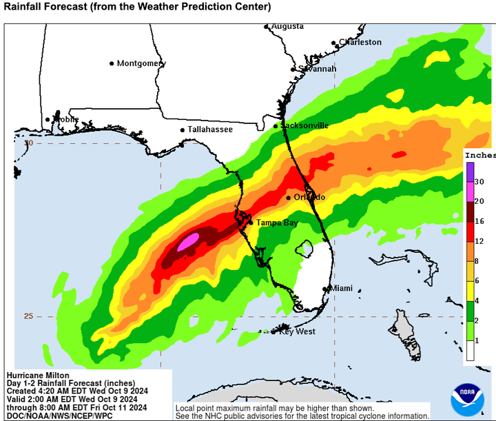
Releasing today's Moody's RMS Event Response update on Hurricane Milton for clients, the team looked at preliminary rainfall observations for the event reported across Florida from the National Weather Service (NWS):
Above 15 inches (381 millimeters):
18.87 in (479 mm) in St. Petersburg Albert Whitted Airport, Pinellas County
17.19 in (437 mm) in Baskin, Pinellas County
16.87 in (428 mm) in Mckay Creek in Largo, Pinellas County
16.04 in (407 mm) in Ormond Beach, Volusia County
15.81 in (402 mm) in Lake Helen, Volusia County
15.66 in (398 mm) in Temple Terrace, Hillsborough County
15.04 in (382 mm) in De Bary, Volusia County
More broadly across the event, parts of Tampa, St Petersburg, Lakeland, Orland, Sanford, and Dayton Beach observed over 10 inches (250 mm) of rainfall.
Over 3 inches (75 millimeters) was observed widely across central Florida, with 1 to 3 inches (25 to 75 millimeters) reported across much of far southern and far northern Florida.
Firas Saleh, Ph.D, who oversees the Moody's RMS U.S. Flood HD Model product, added that Hurricane Milton's impact on Florida resulted in an extraordinary deluge, with areas such as St. Petersburg receiving more than 18 inches (457 millimeters) of rainfall and Tampa experiencing up to 13 inches (330 millimeters).
To put it in perspective, this volume of rain is approximately five times more than the average October rainfall in Tampa, showcasing the severity of this event. This extreme rainfall led to widespread inland flooding, further exacerbated by storm surge effects in certain areas.
Firas added that it is crucial to highlight the significance of antecedent conditions set by previous storms, notably Hurricanes Debby (August) and Helene (September), which in some areas, had a substantial role in exacerbating the impact of Hurricane Milton.
The ground, already saturated from the rainfall brought by these earlier hurricanes was less able to absorb the additional water from Milton, leading to more severe and widespread flooding. This chain of events underscores the cumulative effect of sequential storms on a region's ability to cope with and recover from extreme weather events.
Understanding and preparing for the influence of antecedent conditions is essential for effective flood management and resilience planning.
As a comparison with Hurricane Milton, Moody's RMS Event Response listed the following preliminary rainfall observations reported by the National Weather Service across Florida, Georgia, Alabama, North Carolina, South Carolina, Virginia, West Virginia, Ohio, Kentucky, and Tennessee from 12:00 UTC on Wednesday, September 25 to 02:00 UTC on Saturday, September 28:
30.78 in (782 mm) in Busick Raws, Yancey County, North Carolina
24.20 in (615 mm) in Mount Mitchell, Yancey County, North Carolina
23.25 in (591 mm) in Spruce Pine, Mitchell County, North Carolina
21.27 in (540 mm) in Foscoe, Watauga County, North Carolina
20.12 in (511 mm) in Boone, Watauga County, North Carolina
Clients can access more post-event analysis on Hurricanes Milton, Helene, and Debby from the Support Center.
Friday, October 11: 16:00 UTC
In the latest Moody's RMS Event Response update on Hurricane Milton for clients, the team has examined the preliminary peak wind gust reports from the National Weather Service (NWS):
Over 100 miles per hour (160 kilometers per hour):
105 mph (169 km/hr) at Egmont Channel, Pinellas County
103 mph (166 km/hr) at Tampa Skyway Fishing Pier, Hillsborough County
102 mph (164 km/hr) at Sarasota International Airport, Sarasota County
101 mph (163 km/hr) at St. Petersburg Albert Whitted Airport, Pinellas County
Between 95 and 100 miles per hour (152 to 160 kilometers per hour):
97 mph (156 km/hr) at Tampa, Hillsborough County
96 mph (154 km/hr) at Bradenton, Manatee County
96 mph (154 km/hr) at St. Petersburg, Pinellas County
Major Hurricane Milton made landfall as a Category 3 major hurricane near Siesta Key in Sarasota County, Florida at around 00:30 UTC on Thursday, October 10 (20:30 local time on Wednesday, October 9). At landfall, the system had maximum sustained winds of 120 mph (195 km/hr)/p>
As a recent comparison, for Hurricane Helene, the following preliminary peak wind gusts were reported by the National Weather Service in Florida, Georgia, North Carolina, South Carolina, Tennessee, Kentucky, Illinois, Indiana, and Ohio from 12:00 UTC on Wednesday, September 25 to 02:00 UTC on Saturday, September 28:
106 mph (171 km/hr) in Mount Mitchell, Yancey County, North Carolina
99 mph (159 km/hr) in Perry, Taylor County, Florida
96 mph (154 km/hr) in Lowndes County, Florida
Clients can access more post-event analysis on Milton from the Support Center.
Friday, October 11: 15:15 UTC
In a post on X/Twitter, James Cosgrove from Moody's RMS Event Response remarks on the level of hurricane activity along the U.S. Gulf Coast since 2017.
Before Hurricane Harvey in 2017, the U.S. Gulf Coast had gone around 12 years without a major hurricane (Category 3 or stronger) landfall, since Hurricane Wilma made landfall on October 24, 2005, at Cape Romano, Florida, some 20 miles north of Naples, FL, as a Category 3 storm.
There have been notable Cat 1/2 hurricanes on the Gulf Coast in that time, such as Hurricane Ike in September 2008, which made landfall in Galveston, Texas as a Category 2 storm, with severe storm surge and wind damage.
Since Harvey's landfall at San Jose Island, Texas on August 25, 2017, a category 4 hurricane, this was quickly followed by Hurricane Irma, another category 4 hurricane making landfall some 16 days later at Cudjoe Key, FL, on September 10, 2017.
Year
Major Landfalling U.S. Gulf Coast Hurricanes: Cat 3 or greater
Total
2017
Harvey (August) Cat 4; Irma (Sept) Cat 4
2
2018
Michael (October) Cat 5
1
2019
0
2020
Laura (August) Cat 4; Zeta (October) Cat 3
2
2021
Ida (August) Cat 4
1
2022
Ian (September) Cat 4
1
2023
Idalia (August) Cat 3
1
2024
Helene (September) Cat 4; Milton (October) Cat 3
2
TOTAL
10
For the 2024 North Atlantic Hurricane season, all five landfalling hurricanes (Category 1-5) in the U.S. in 2024, Beryl, Debby, Francine, Helene, and Milton have made landfall along the U.S. Gulf Coast. This ties 2005 and 2020 for the second-most U.S. Gulf Coast landfalls in a single season on record.
Clients can access regular, detailed updates on Milton from the Support Center.
Friday, October 11: 14:30 UTC
Big thanks to our Moody's HWind team who have issued regular wind field snapshots, footprints, and track forecasts for Hurricane Milton since it was first identified as Tropical Depression 14 - with the first footprint issued at 18:00 UTC on Saturday, October 5.
Here is the HWind Hurricane Milton Real-Time wind field footprint for the entire event.
From its origins as Tropical Depression 14 on Saturday, October 5, the footprint shows its rapid intensification to a Category 4 event on Monday, October 7 at 13:05 UTC, and to a Category 5 major hurricane less than three hours later at 15:55 UTC.
Milton weakened to a Category 3 into Wednesday, October 9, but the storm broadened, with tropical-force-winds extending up to 255 miles (405 kilometers). Making landfall early on Thursday morning UTC, locally Wednesday evening at Category 3 strength, it maintained hurricane strength as it crossed Florida.
The National Hurricane Center (NHC) declared Milton as a post-tropical storm over the Atlantic on Thursday, October 10, in an 18:00 UTC bulletin, marking the last update from HWind.
HWind clients can access wind field, footprint, and forecast data for Milton from the Support Center. Clients who use the ExposureIQ application on the Intelligent Risk Platform with a valid HWind subscription can access HWind data directly into ExposureIQ.
Thursday, October 10: 20:30 UTC
Moody's RMS Event Response examined tornado activity that impacted central and southern Florida, as this sizeable hurricane made its approach toward Florida's west coast late on Wednesday, October 9 local time.
The National Weather Service (NWS) offices in Florida issued 126 tornado warnings on Wednesday, October 9, and this ranks as the most tornado warnings issued in Florida on a single day on record.
126 tornado warnings for Florida in a single day is the second-highest number of tornado warnings ever issued in the United States in a single state during one day.
Florida's total is only beaten by the 2011 Super Outbreak in Alabama on April 27, 2011, with 134 tornado warnings.
At least 27 tornadoes were reported in Florida on Wednesday, October 9, according to the NWS.
In St. Lucie County, FL, an unconfirmed tornado tracked through the Spanish Lakes Country Club mobile home retirement community in Fort Pierce, which caused fatalities and injuries, and some homes to be damaged.
Media reports state that as many as five people were killed Wednesday after at least two confirmed tornadoes tore through St. Lucie County, as confirmed by Florida's Governor Ron DeSantis in a press conference on Thursday afternoon.
Unconfirmed tornado damage in Florida was also reported in Glades County, Brevard County, Martin County, Highlands County, Palm Beach County, and Lee County.
Clients can access regular, detailed updates on Milton from the Support Center.
Thursday, October 10: 19:00 UTC
According to the latest event description released to Moody's RMS Event Response clients on Hurricane Milton, 2024 is only the seventh year on record with five or more landfalling hurricanes in the continental U.S., as Milton is added to this season's list of Beryl (July), Debby (August), Francine (September), and Helene (September).
The most recent season with five or more landfalling hurricanes in the continental U.S. was 2020 (Hanna, Isaias, Laura, Sally, Delta, Zeta), a season with 30 named storms and 14 hurricanes.
Other years with five or more landfalling hurricanes in the continental U.S. include 1886, 1893, 1985, 2004, and 2005 with 28 named tropical storms, 15 hurricanes, and six U.S. landfalling hurricanes (Cindy, Dennis, Katrina, Ophelia, Rita, Wilma).
All five landfalling U.S. hurricanes in 2024 (Beryl, Debby, Francine, Helene, and Milton) have made landfall along the U.S. Gulf Coast. This ties 2005 and 2020 for the second-most U.S. Gulf Coast landfalls in a single season on record.
Milton has also claimed records for Florida's west coast:
Milton is the strongest hurricane to make landfall on the central-west coast of Florida on record. It surpasses the Tampa Bay hurricane (1921), which made landfall as a Category 3 major hurricane with maximum sustained wind speeds of 115 mph (185 km/hr) near Tarpon Springs, Pinellas County, Florida on October 25, 1921
Milton is the first major hurricane to make landfall in Sarasota County, Florida on record
Clients can access regular, detailed updates on Milton from the Support Center.
Thursday, October 10: 15:00 UTC
In its latest event description released to Moody's RMS Event Response clients on Hurricane Milton, the team looked at the historical records to see how Milton and Florida's hurricane season so far, compare to previous seasons:
With Milton the third hurricane to make landfall so far in Florida during 2024, following Debby and Helene, this total ties with 1871, 1886, 2004 (inc. Charley), and 2005 (inc. Wilma) for the greatest number of hurricanes to make landfall in Florida in a single season on record.
Milton is also the second major hurricane to make landfall in Florida in 2024, following Helene - only the fourth occasion that two major hurricanes have made landfall in Florida in a single season.
Milton made landfall 13 days after Helene made landfall as a Category 4 major hurricane in Perry County, Florida on Thursday, September 26 - the fewest number of days between major hurricane landfalls in Florida on record.
Clients can access regular, detailed updates on Milton from the Support Center.
Thursday, October 10: 10:00 UTC
Hurricane Milton is now in the Atlantic, as the National Hurricane Center (NHC) advisory at 09:00 UTC Thursday, October 10, stated that the storm was around 10 miles (15 kilometers) northeast of Cape Canaveral, FL, on Florida's east coast. Milton's maximum sustained winds were at 85 miles per hour (140 kilometers per hour) with higher gusts, with Milton retaining its Category 1 hurricane strength status.
In terms of Milton's size, hurricane-force winds extended outward up to 35 miles (55 kilometers) from its center, and tropical-storm-force winds extended outward up to 205 miles (335 kilometers).
Hurricane and tropical storm warnings have now been discontinued for locations on Florida's west coast, with additional warnings in place on Florida's east coast. Additional rainfall of two to four inches (50-100 millimeters) was expected for east-central and eastern coastal locations in the state, continuing the risk of considerable flash and urban flooding.
Clients can access regular, detailed updates on Milton from the Support Center.
Thursday, October 10: 07:00 UTC
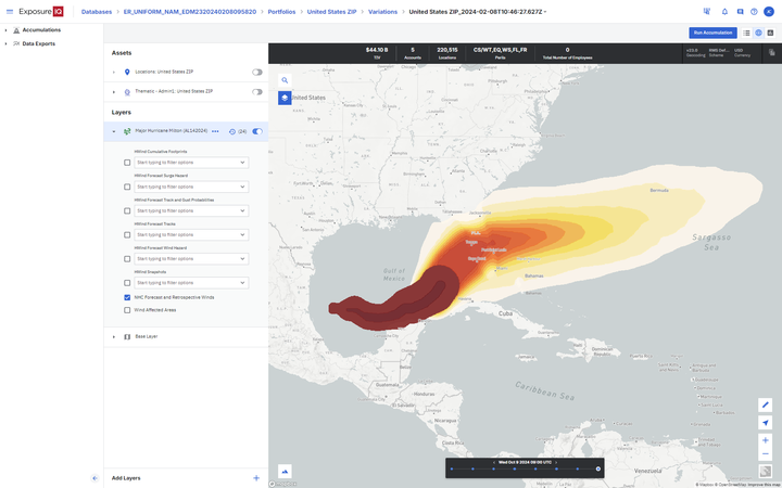
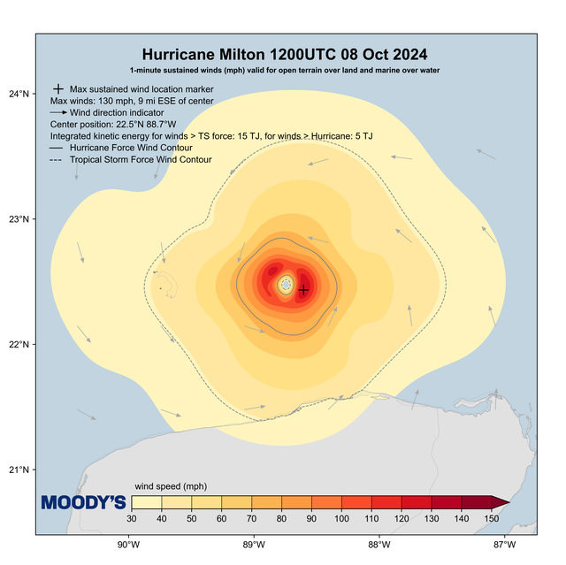
The Moody's HWind wind field snapshot from 00:00 UTC Thursday, October 10, shows HurricaneMilton around thirty minutes before landfall, with maximum sustained winds of 106 miles per hour (171 kilometers per hour), and tropical storm force winds extending to most of Florida's west coast.
In this HWind wind field snapshot, Milton's estimated Integrated Kinetic Energy (IKE) for hurricane-force winds at eight Terajoules (TJ), with tropical storm force winds at 45 TJ.
Hurricane Milton made landfall as a Category 3 storm at around 00:30 UTC (Thursday, October 10), 20:30 EDT Wednesday, October 9, near Siesta Bay, Florida - a barrier island in front of Sarasota.
Examining the real-time HWind snapshot and footprint track issued six hours later at 0600, Thursday, October 10, showed that maximum sustained winds were at 79 miles per hour (127 kilometers per hour) at Category 1 strength, with wind speeds of 40 to 80 miles (64 to 128 kilometers) per hour across most of the state.
For the latest HWind updates, HWind clients can access regular wind field, footprint, and forecast data for Milton from the Support Center. Clients who use the ExposureIQ application on the Intelligent Risk Platform (see snapshot above) with a valid HWind subscription can access HWind data directly into ExposureIQ.
Thursday, October 10: 00:30 UTC
The National Hurricane Center has issued an advisory at 00:30 UTC Thursday, 10 October (20:30 EDT Wednesday, 9 October), that Hurricane Milton made landfall as a Category 3 storm on the Saffir-Simpson Hurricane Wind Scale, near Siesta Key, Sarasota County, on Florida's West Coast.
Milton has maximum sustained winds of 120 miles per hour (205 kilometers per hour), with recorded wind gusts of 78 miles per hour (126 kilometers per hour) in Venice, FL.
Milton is expected to remain as a hurricane as it moves across central Florida through Thursday, with warnings for damaging winds, storm surge, and severe rainfall with localized totals up to 18 inches (450 millimeters) causing inland flooding.
Hurricane Milton is moving at 17 miles per hour, (28 kilometers per hour) toward the northeast, according to the latest advisory issued by the National Hurricane Center (NHC) at 21:00 UTC on Wednesday, October 9, some 60 miles (100 kilometers) west-southwest of Sarasota, Florida, and this motion is expected to continue tonight local time.
A Category 3 hurricane on the Saffir-Simpson Hurricane Wind Scale, Milton's maximum sustained winds are near 120 miles per hour (195 kilometers per hour), and it is forecast to be a major hurricane at landfall, and remain a hurricane as it moves through central Florida on Thursday.
The NHC advisory has Milton's landfall location as near or south of the Tampa Bay region this evening local time.
Wind gusts of 68 miles per hour (109 kilometers per hour) have been recorded at a mesonet automated weather station located in Fort Myers Beach, according to an update from the National Hurricane Center (NHC) issued at 20:00 UTC.
Hurricane Milton is now a Category 3 storm with maximum sustained winds of 125 miles per hour (205 kilometers per hour), and is located about 100 miles (160 kilometers) west-northwest of Fort Myers, and about 100 miles (155 kilometers) southwest of Tampa.
The advisory also stresses the multiple tornado warnings in effect across the Florida peninsula.
In their latest release at 18:00 UTC today (Wednesday, October 9), Moody's HWind team wind field snapshot for Major Hurricane Milton indicates a significant strengthening compared to the previous update six hours earlier at 12:00 UTC.
The HWind noon UTC wind field snapshot issued earlier today estimated Milton's Integrated Kinetic Energy (IKE) for hurricane-force winds at seven Terajoules (TJ), with tropical storm force winds at 23 TJ. The latest 18:00 UTC snapshot raises the IKE for hurricane-force winds to 14 TJ and tropical-storm-force winds to 48 TJ.
Maximum sustained winds are now at 122 miles per hour (196 kilometers per hour), placing Milton as a Category 3 storm on the Saffir-Simpson Hurricane Wind Scale.
The real-time HWind snapshot and track issued at 18:00 show how the maximum sustained winds for Major Hurricane Milton have reduced over the last 24 hours.
For the latest HWind updates, HWind clients can access regular wind field, footprint, and forecast data for Milton from the Support Center.
Clients who use the ExposureIQ application on the Intelligent Risk Platform (see snapshot above) with a valid HWind subscription can access HWind data directly into ExposureIQ.
Wednesday, October 9: 18:30 UTC
Major Hurricane Milton has reportedly grown in size according to the latest National Hurricane Center (NHC) advisory issued on Wednesday, October 9, at 18:00 UTC.
The advisory states that hurricane-force winds extend outward up to 35 miles (55 kilometers) from the center, and tropical-storm-force winds extend outward up to 250 miles (402 kilometers), a substantial increase compared to NHC advisories issued earlier today.
On the NHC forecast track, Milton is set to make landfall on the west-central coast of Florida tonight (Wednesday) local time.
Maximum sustained winds are near 130 miles per hour (215 kilometers per hour) with higher gusts, and Milton remains a Category 4 storm on the Saffir-Simpson Hurricane Wind Scale (SSHWS).
Storm surge warnings of 8-13 feet (2.4-3.9 meters) are in place in locations from Tampa through to areas such as Bonita Beach.
Clients can access regular, detailed updates on Milton from the Support Center.
Wednesday, October 9: 15:15 UTC
Moody's RMS Event Response has released its latest public synopsis on Milton's current status and outlook over the coming days.
With maximum sustained winds of 155 miles per hour (250 kilometers per hour) as of 12:00 UTC on Wednesday, October 9, Milton is a Category 4 major hurricane located around 250 miles (405 kilometers) southwest of Tampa, Florida, and is tracking northeast over the eastern Gulf of Mexico towards the west coast of Florida.
Milton is forecast to make landfall as a Category 4 major hurricane near Sarasota, Florida at around 06:00 UTC (02:00 local time) on Thursday, October 10, although the exact timing, location, and intensity at landfall remain uncertain.
Milton has the potential to be one of the most destructive hurricanes on record for west-central Florida, according to the National Hurricane Center (NHC).
In the Event Response synopsis, Milton has the potential for devastating hurricane-force winds that are expected to impact the west coast of Florida near to where the center makes landfall and along its path across the state.
With storm surge a major risk for Florida's west coast communities, Milton is expected to produce a large area of destructive storm surge along portions of the west-central coast of Florida.
As Firas Saleh mentioned in an earlier post, the synopsis states that heavy rainfall is forecast across portions of the Florida Peninsula and the Florida Keys through Thursday, October 10, which could cause catastrophic and life-threatening flash and urban flooding, moderate to major river flooding, and inland flooding.
Clients can access regular, detailed updates on Milton from the Support Center.
Wednesday, October 9: 14:45 UTC
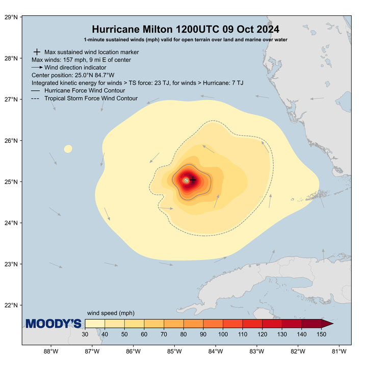
The latest Moody's HWind wind field snapshot for Major Hurricane Milton issued at 12:00 UTC today, Wednesday, October 9, sees the storm's maximum sustained winds at 157 miles per hour (252 kilometers per hour), making Milton a high-end Category 4 event in terms of wind strength.
Examining Milton's Integrated Kinetic Energy (IKE), hurricane-force winds are seven Terajoules (TJ), with tropical storm force winds at 23 TJ.
For the latest HWind updates, HWind clients can access regular wind field, footprint, and forecast data for Milton from the Support Center. Clients who use the ExposureIQ application on the Intelligent Risk Platform with a valid HWind subscription can access HWind data directly into ExposureIQ.
Wednesday, October 9: 14:00 UTC
As Florida prepares for the impacts of Hurricane Milton, Firas Saleh, Ph.D, who oversees the Moody's RMS U.S. Flood HD Model product, comments that it's crucial to understand the distribution of flood insurance coverage in Florida, especially in the context of the expected heavy rainfall and its potential to cause significant inland flooding.
Hurricane Milton rainfall forecast for the next 48 hours (Source: NWS/WPC)
>Florida leads the U.S. with approximately 37 percent share of all National Flood Insurance Program (NFIP) policies in force which total 4.65 million, but Firas reminds us that it's important to note that most of these policies are concentrated in coastal areas; regions that are particularly vulnerable to storm surge, a primary factor driving the higher uptake of flood insurance.
In contrast, inland areas of Florida facing the threat of over 15 inches of rain from Hurricane Milton according to the latest forecasts from the National Weather Service Weather Prediction Center, have much lower NFIP penetration rates, with less than five percent of homes insured against flood.
Firas added:
This highlights a critical gap in flood preparedness, with inland areas significantly underinsured against flooding that can occur from such substantial rainfall events.
This situation emphasizes the need for increased awareness and adoption of flood insurance in Florida's inland regions, which, while less susceptible to storm surge, are still vulnerable to the devastating effects of heavy rains and flooding, especially in the wake of previous storms that have already saturated the ground.
Wednesday, October 9: 10:00 UTC
Jeff Waters, CCRA, CCRMP was featured on CNBC yesterday (Tuesday, October 8) with insights on Hurricanes Milton and Helene.
Recognizing that Milton would impact Florida's west coast with a potential direct track to major cities such as Tampa, for properties that were damaged by Helene just two weeks ago, Jeff looks at how Helene's prior damage and debris could exacerbate losses from the incoming Milton hurricane.
Jeff talks about the recent Helene insured loss estimate issued by Moody's RMS Event Response, the rarity of a direct track to a major Florida west coast city, and how strong building codes and construction methods will be tested by Milton.
Building codes in Florida are some of the strongest in the country. However, there will be an overlap between properties impacted by Helene and also by Milton.
Damage from Milton could be exacerbated by properties already damaged for Helene, and it will be hard to know which event caused the impact.
Jeff Waters, Director - Product Management, Moody's
The Insurer reported on a just-released Moody's data analysis and estimate, examining commercial real estate in Florida with a more than a 50 percent chance of being exposed to wind speeds greater than 50 miles per hour from Major Hurricane Milton.
The analysis was generated yesterday (October 8), and estimates exposure of commercial real estate properties to wind hazard only, based on Moody’s RMS HWind data using the ExposureIQ™ app to identify the likelihood of locations experiencing 3-second peak gusts above different threshold wind speeds.
The analysis does not consider flooding or storm surge effects, and actual damage to properties is based on a range of factors, including asset-level and regional risk mitigation measures. Exposure values were based on a rough approximation of property values using the average price per unit or square foot for recent transactions in the geographic region.
Using a track prediction for Milton from Tuesday, October 8, the storm was forecast to pass over the Tampa Bay area and continue across Central Florida toward the Atlantic Ocean, and from the analysis, around 250,000 commercial properties worth around $1.1 trillion in value could have a more than 50 percent chance of being exposed to wind speeds greater than 50 miles per hour from Major Hurricane Milton.
The published data visualization allows you to explore cities, and commercial usage categories, and get an overview of concentrations of exposure.
Maximum sustained winds for Major Hurricane Milton in the advisory issued by the National Hurricane Center (NHC) showed a slight weakening in Milton's maximum sustained wind speeds as of Wednesday, October 9, at 06:00 UTC, recorded at 160 miles per hour (260 kilometers per hour) but with higher speed gusts, and a central pressure of 914 hPa.
Maintaining its Category 5 strength on the Saffir-Simpson Hurricane Wind Scale, Milton's location was 360 miles (585 kilometers) southwest of Tampa, Florida.
Milton is moving toward the northeast near 12 miles per hour (19 kilometers per hour). A northeastward motion with some increase in forward speed is expected through tonight.
A turn toward the east-northeast and east is expected on Thursday and Friday. Weather conditions are expected to deteriorate this (Thursday) afternoon local time.
Source: National Hurricane Center
The latest advisory states that hurricane-force winds extend outward up to 30 miles (45 kilometers) from the center and tropical-storm-force winds extend outward up to 140 miles (220 kilometers).
Tuesday, October 8: 22:15 UTC
The latest advisory for Major Hurricane Milton issued by the National Hurricane Center (NHC) reports that Milton's maximum sustained wind speeds as of Tuesday, October 8, at 21:00 UTC, were 165 miles per hour (270 kilometers per hour) with a central pressure of 918 hPa.
Major Hurricane Milton has returned to Category 5 strength on the Saffir-Simpson Hurricane Wind Scale. Milton's location was 480 miles (790 kilometers) southwest of Tampa, Florida.
Recent observations from an Air Force Reserve Hurricane Hunter indicated that the central pressure in the eye of Milton had fallen to an estimated 905 hPa.
The latest advisory states that hurricane-force winds extend outward up to 30 miles (45 kilometers) from the center and tropical-storm-force winds extend outward up to 140 miles (220 kilometers).
Tuesday, October 8: 22:00 UTC
Major Hurricane Milton is expected to produce a large area of destructive storm surge along portions of the west coast of Florida, with NOAA and the National Weather Service forecasting between 10-15 feet of peak storm surge, as Milton makes projected landfall in less than 36 hours.
But what do the potential track forecasts tell us about landfall intensity and locations along the coast, and how will these factors impact storm surge levels?
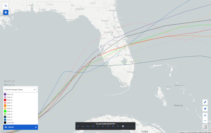
Tracks of the ten HWind forecast scenarios and the NHC for forecasts initialized at 00:00 UTC on October 8, 2024, within ExposureIQ.
In a new blog, Callum Higgins looks at the latest Moody's HWind forecast track ensembles for Milton, to assess the best and worst-case scenarios in terms of storm surge impact.
For example, within our latest HWind forecasts including storm surge (initialized at 0000 UTC on Tuesday, October 8) there are scenarios where losses are both significantly higher and lower than those modeled from the NHC’s parameters.
While still significant, the scenarios with the least potential for storm surge loss have Milton tracking much farther south, making landfall near Cape Coral, with a lower intensity of Category 1 or 2.
This combined with the majority of the surge hazard affecting regions that are both less susceptible to surge and with lower exposure towards the Everglades results in lower losses.
The scenarios with the highest potential for storm surge losses make landfall north of the entrances to either Tampa Bay or Charlotte Harbor as a major hurricane.
New updates from Moody's RMS Event Response using provisional data help to go into more detail about the rapid intensification of Major Hurricane Milton over the southern Gulf of Mexico.
Milton attained hurricane intensity at 18:00 UTC (13:00 local time) on Sunday, October 6, and at this time, the system had maximum sustained winds of 80 miles per hour (130 kilometers per hour) which corresponded to a Category 1 hurricane on the Saffir-Simpson Hurricane Wind Scale (SSHWS).
Milton then underwent a period of 'extreme rapid intensification' on Monday, October 7, to intensify from a Category 1 hurricane to a Category 5 major hurricane in less than 24 hours.
Milton attained...
Category 2 hurricane intensity on Monday, October 7 at 09:00 UTC
Category 3 hurricane intensity two hours later at 11:00 UTC
Category 4 major hurricane intensity just over two hours later at 13:05 UTC
Category 5 major hurricane intensity just under three hours later at 15:55 UTC
At around 21 hours, this makes Milton the second-fastest hurricane to intensify from a Category 1 event to a Category 5 major hurricane on record, behind Wilma in late October 2005.
For Wilma, it exploded from a Category 1 hurricane with sustained winds of 80 miles per hour (130 kilometers per hour) to a major Category 5 event with winds of 175 miles per hour (280 kilometers per hour) in just 12 hours between October 18 and 19. 2005.
Late on October 21, 2005, Wilma made the first of its two landfalls in Mexico, on the island of Cozumel, Quintana Roo, with sustained winds of 150 miles per hour (240 kilometers per hour), followed by a second landfall just six hours later on October 22, 2005, at 03:30 UTC near Puerto Morelos with winds at 135 miles per hour (215 kilometers per hour).
Wilma caused significant damage to the Yucatan Peninsula in Mexico, and also Jamaica, and a further landfall on October 24, 2005, in southwestern Florida near Cape Romano around 10:30 UTC with winds of 120 miles per hour (190 kilometers per hour).
Rapidly crossing the state did weaken Wilma to a Category 2 hurricane, but it then briefly re-intensified to a Category 3 hurricane once in the Atlantic, while passing north of the Bahamas.
Event Response also added that Milton's intensification rate was among the fastest of any hurricane in the North Atlantic Basin in the recent satellite-era over a 24-hour, 42-hour, 48-hour, and 54-hour period.
Between 21:00 UTC on Monday, October 7, and 00:00 UTC on Tuesday, October 8, Milton continued to intensify and reached a lifetime peak wind intensity of 180 miles per hour (285 kilometers per hour).
Milton's peak intensity ranks as the tied-third strongest hurricane (by maximum wind speed) in the North Atlantic on record:
Hurricane Allen (August 1980, 190 miles per hour/305 kilometers per hour)
Labor Day Hurricane (September 1935, 185 miles per hour/295 kilometers per hour)
Hurricane Gilbert (September 1988, 185 miles per hour/295 kilometers per hour)
Hurricane Dorian (August/September 2019, 185 miles per hour/295 kilometers per hour)
Milton is only the third hurricane to attain an intensity of 180 miles per hour (295 kilometers per hour) or greater in the Gulf of Mexico on record, following Allen (1980) and Rita (2005).
With reconnaissance aircraft observing a minimum central pressure of 897hPa in the center of Milton shortly before 00:00 UTC on Tuesday, October 8, this ranks as the fifth lowest observed minimum central pressure on record, behind Wilma (2005, 882 hPa); Gilbert (1988, 888 hPa), Labor Day (1935, 892 hPa); and Rita (2005, 895 hPa).
Clients can access regular, detailed updates on Milton from the Support Center.
Tuesday, October 8: 17:00 UTC
The Moody's HWind team has been publishing regularly updated wind field snapshots, footprints, and track forecasts for Major Hurricane Milton since it was named a tropical storm on Saturday, October 5.
This latest HWind snapshot shown below, published at 12:00 UTC today, showed Milton as a Category 4 strength major hurricane, just north of Mexico's Yucatán Peninsula.
Commenting on the snapshot, the HWind team stated that while an eyewall replacement cycle has lowered Milton's maximum sustained wind speed (Vmax) down to 130 miles per hour, compared to previous HWind snapshots from 00:00 UTC, and 06:00 UTC today, Milton's wind field has expanded.
There has also been an increase in the tropical storm force Integrated Kinetic Energy (IKE) from 00:00, 06:00, and 12:00 UTC snapshots, increasing from seven to nine, and now to 15 terajoules (TJ) respectively.
Jeff Waters, Director - Product Management, for Moody's, who leads the North Atlantic Hurricane Model development, commented:
During real-time events like Hurricane Milton, Moody's HWind has continuous feeds to numerous sources of observational wind data.
The team uses this to produce snapshots and cumulative footprints on a 6-hourly cadence, allowing us and users to see the evolution of the wind field size and intensity over time - leading up to and following landfall - including periods of rapid intensification and eyewall replacement cycles."
HWind clients can access regular wind field, footprint, and forecast data for Milton from the Support Center. Clients who use the ExposureIQ application on the Intelligent Risk Platform with a valid HWind subscription can access HWind data directly into ExposureIQ.
Major Hurricane Milton will potentially make landfall in Florida some 50-100 miles from where Major Hurricane Helene made landfall as a Category 4 strength hurricane in Florida's Big Bend on Thursday, September 26, 2024, a time gap of no more than two weeks.
In addition to Helene's destructive winds, Florida also received significant rainfall from Helene.
The National Weather Service rainfall records for 12:00 UTC on Wednesday, September 25, to 02:00 UTC on Saturday, September 28 showed locations such as Sumatra in Liberty County, Florida receiving 15.91 inches (404 mm) of rainfall during this period.
Although not as high as the 20-30 inches of rainfall in North Carolina for Helene, wet antecedent conditions in Florida from the previous hurricane, with saturated grounds and higher river levels, could raise the risk of significant inland flooding from Milton.
Firas Saleh, Director - Product Management, for Moody's, who leads the U.S. Flood HD Model development, commented:
As Major Hurricane Milton approaches Florida, regions already reeling from the impacts of Hurricane Helene brace for further challenges. Antecedent conditions in these areas will significantly influence the extent of inland flooding expected from Milton.
Many rivers are still swollen from the previous hurricane. The additional rainfall brought by Milton is likely to exacerbate these conditions, potentially elevating water levels further and increasing the risk of significant inland floods.
Moody's RMS Event Response released an insured loss estimate for Major Hurricane Helene, to find out more, click here.
Tuesday, October 8: 12:00 UTC
To help our clients during this fast-developing 2024 North America hurricane season, and as Florida anticipates the landfall of dangerous Major Hurricane Milton, Jeff Waters, CCRA, CCRMP introduces newly updated Moody’s RMS HWind forecasting products in a new blog – featuring new combined (forecast and trailing) loss-producing footprints.
With this next phase of HWind innovation now available on Moody’s Intelligent Risk Platform, Jeff explains how loss-producing HWind forecasting products are now integrated within the Risk Modeler application, to support bulk footprint analyses (also known as Ensemble Conditional Exceedance Probability or CEP), and enable automation of event response processes via an API.
As we know (re)insurers, policyholders, and investors' expectations for timely, accurate information during and following real-time events at an all-time high during major events, find out how these new developments can help ensure better data-driven decisions - before, during, and after an event happens, in Jeff's new blog here: "More Accurate Real-Time Hurricane Loss Estimates with HWind Forecasting Footprints."
Tuesday, October 8: 10:30 UTC
Sarah Hartley and James Cosgrove from Moody's RMS Event Response have just published a blog entitled "Stark Warnings for Major Hurricane Milton" as Florida county and state officials issue dire warnings about the incoming major hurricane and its potential impact on Florida.
With less than 48 hours until a potential landfall, preparations for the storm are well underway, with State of Emergency declarations and evacuation orders in place, for an evacuation that could be as large as for Hurricane Irma in 2017. On the current status of Major Hurricane Milton, and its prospects for the days ahead, Sarah and James stated:
Milton is expected to encounter strong vertical wind shear and dry air entrainment on its approach to the Florida Gulf Coast and is expected to weaken slightly as it nears landfall, but is it still currently forecast to make landfall as a powerful Category 3 major hurricane on the west coast of Florida late local time on Wednesday, October 9. The exact timing, location, and intensity at landfall remains uncertain.
Damaging hurricane-force winds are expected to impact the west coast of Florida near where the center makes landfall and crosses the Peninsula, and a life-threatening storm surge could occur along portions of the west coast of the Florida Peninsula, especially in areas to the south of the where the center makes landfall. Debris and damaged structures from Helene, and clear-up operations will be vulnerable.
Building on a 20-year track record, the dedicated Moody’s RMS Event Response team monitors real-time catastrophes daily to provide clients with information and products to assess the potential impact on their own portfolios.