RMS HWind: Advances in Real Time Hurricane Guidance and Forecasting
Jeff WatersAugust 07, 2020
As we move into the third month of the current hurricane season in the tropical North Atlantic, it has been a busy start with a record nine named storms to date. Thankfully, none of these events have been particularly intense or damaging, but this may change as the season reaches its climatological peak.
Many of the latest forecasts continue to suggest that warmer-than-average sea surface temperatures will persist and La Niña conditions emerge during this peak season, creating favorable conditions for above-average tropical cyclone development and intensification.
All (re)insurers, brokers, and capital markets entities with hurricane exposure or risk monitor the tropics in some capacity, wanting to know the implications of the next impactful event.
RMS has helped clients manage their risk during hurricane events in the North Atlantic for almost 20 years, with a comprehensive set of event response products and services from pre- to post-landfall including qualitative event summaries, accumulation products, and loss modeled tools.
RMS built on this capability when acquiring HWind in 2015, and subsequently bringing to market observation-based products and insights to help clients understand tropical cyclone wind hazard. And since 2019, real time forecasts are a now a growing part of the RMS HWind offering.
Why all the focus and investment in this space? Because real time hurricanes can significantly impact a company’s financial, operational, and sometimes overall solvency state. They can even reshape the market.
For 2020, the HWind forecasting solution has been expanded further to help the market to gain insights throughout an event, so (re)insurers can make timely, informed decisions. These decisions, and the insights that inform them, often start before the storm makes landfall. Companies try to determine potential hazard and loss impacts to exposures at risk and the corresponding uncertainties therein to help answer questions like:
Could this event impact our business? If so, how much exposure and exposed limit is at risk? Which policies, contracts, and exposures are at the most risk?
What are the potential losses to my book(s) or cedant book(s)? What is the uncertainty in those losses? How confident am I to report on the event and forecast impacts on my portfolio internally or externally?
How many claims adjusters will we need? Where do we send our adjusters in advance on the event to position them most efficiently to start the post-event claims work? Will they be safe?
Do we need to purchase additional reinsurance?
Do we adjust our underwriting guidelines based on the forecast?
What does this mean for the cat bonds and/or ILWs I have in place?
These are critical decisions, involving real money and real resources. And in many cases, we have seen that company reputations can be on the line, as a poor response can be viewed as a proxy for weak internal processes.
Taking Advantage of Forecasting Solutions
For those with pre-landfall event response processes, now is the time to ensure you are utilizing real time hurricane forecasting information such as HWind that provides timely insights when you need it most. This can make the difference between an average response and a market-differentiating response where you feel confident you are making the best, informed decisions over time.
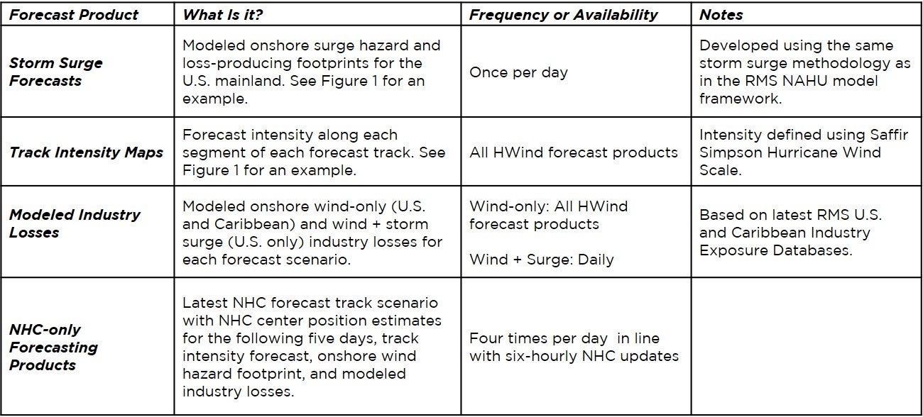
Launched in 2019, the first foundational version of the HWind forecasting solution for Atlantic events offered a product suite including a set of forecast tracks, track and gust probability metrics, and individual wind hazard and wind loss-producing scenario footprints for the following five days.
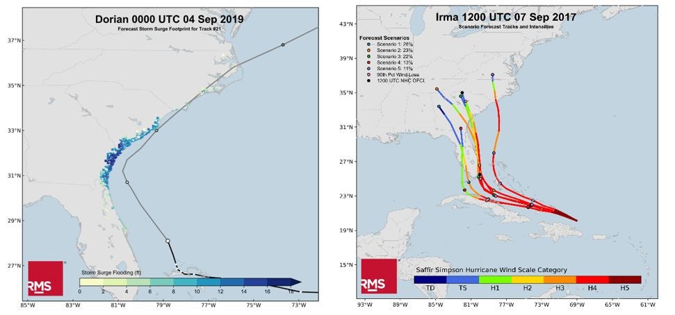
Figure 1: Sample storm surge footprint for Hurricane Dorian (2019) (left); sample track intensity forecasts for Hurricane Irma (2017) (right)
These products were developed twice per day using a combination of real time track forecasts from domestic and international weather forecast models, observation data-based insights from HWind, and the RMS North Atlantic Hurricane Models modeling framework. For 2020, we have now expanded the HWind forecasting framework to include the following notable updates, among other enhancements:
Collectively, the HWind forecasting product updates expand the amount of information that can be discerned about potential track, hazard and loss impacts during an active event. The corresponding analytics and insight support a variety of pre-landfall event response applications, including the ability to:
Understand forecast track, timing, intensity, and uncertainty across multiple forecast scenarios, starting up to five days before landfall
Quantify exposures, exposed limits, or policies at risk
Quantify potential industry or portfolio losses, downtime, and other asset impacts based on the same hazard, vulnerability, and financial estimation framework as implemented in the RMS North Atlantic Hurricane Models
Event response teams can use these tools to derive timely insights and support many decisions in advance of landfall, including internal and external reporting, securing and appropriately positioning claims adjusters and other recovery assets, planning policyholder outreach, and evaluating real-time, or ‘live’ catastrophe coverage, cat bonds, or ILWs.
Equally important to ensure proper preparation measures is the need to communicate uncertainties around these decisions. That range of uncertainty may be higher this season due to the ongoing coronavirus pandemic causing reduced air traffic, which in turn reduces the amount of observational data on weather patterns and conditions, leading to a wider range of uncertainty in weather forecasts.
As we gear up for the climatological peak of hurricane season, now is the time for companies to ready themselves and their hurricane event response processes, especially before landfall. If and when tropical cyclone activity escalates and storms begin threatening exposures at risk, it can become a hectic and fraught time for the market. HWind forecasting products can provide the necessary insights to help you stay ahead of the storms and remain proactive, informed, and most importantly, prepared.
Every twist and turn of a real-time hurricane can affect global financial markets, public safety, or government and international aid agencies that provide assistance. Within the (re)insurance space, the ability to understand forecast track, timing, and potential hazard and loss impacts before landfall helps entities to prepare and execute their event response processes effectively. This includes having adequate capital to cover claims, setting up claim centers and planning policyholder outreach, securing and positioning adjusters in areas that are likely to be impacted, and determining what, if any, risk can be ceded to reinsurance or capital markets.
For our clients, the traditional approach to quantify potential impacts ahead of a landfalling storm involves selecting similar storms from the RMS® North Atlantic Hurricane (NAHU) stochastic event set. While this generates vital insights that can be extracted quickly from internal databases, there are opportunities to provide earlier and more comprehensive insights into the storm ahead of landfall.
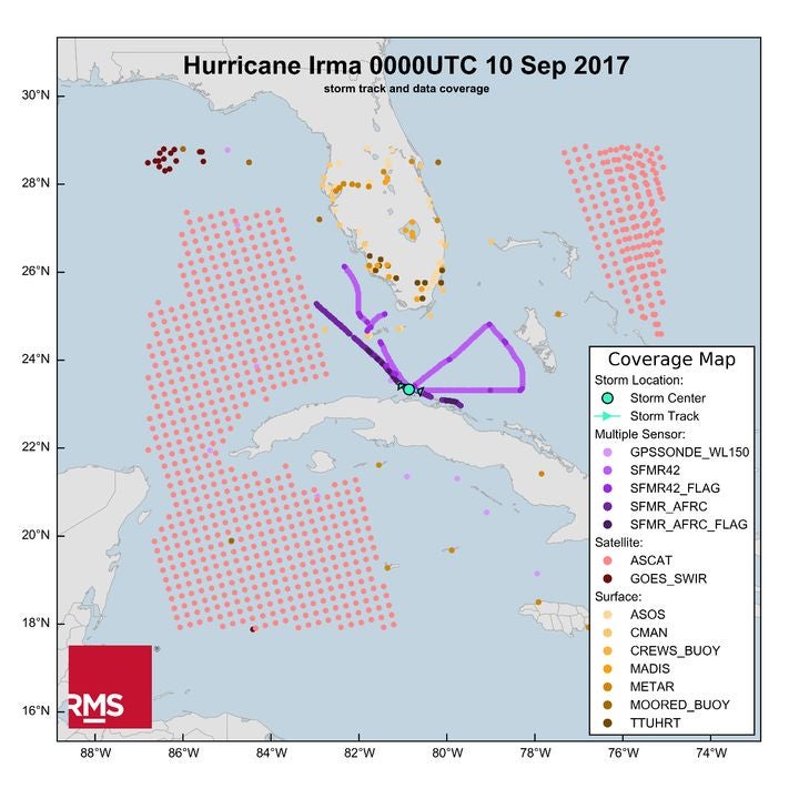
To date, RMS clients have also benefited from real-time analysis of hurricane events through RMS HWind Real-Time Analysis products. These observation data-based snapshots and footprints have provided the industry with a standard “ground truth” representation of tropical cyclone wind field size and intensity before, during, and following landfall effectively helping to describe what the storm is doing and what the storm has done.
Building on this framework, RMS has expanded its HWind Real-Time Analysis offering to include a forecasting solution for all named tropical cyclone events in the North Atlantic Basin. This was developed using a proprietary methodology that combines real-time forecast track data from weather forecasting models, HWind data, and the RMS North Atlantic Hurricane Models modeling framework. The forecasting products consist of five-day forecast track scenarios, gust probability analytics and individual forecast hazard footprints made available every 12 hours once the storm has been named.
Cooking Up Forecasting Spaghetti: Making Sense of Track Forecasts
There is a sea of track forecasting information available via Numerical Weather Prediction (NWP) centers across the globe. Adding up all these available weather forecasting models results in over 100 different track forecasts for any given storm, forming an intractable “spaghetti” of solutions. Differences in these solutions can be due to a number of things that can vary by model, including the underlying physics governing the atmospheric and oceanic patterns, weak or complex steering flows, or the timing of a storm’s interaction with approaching large-scale weather systems (see figure below for example for Hurricane Joaquin in 2015).
While hurricane track forecasting has improved steadily over the years as models have been upgraded with better data assimilation systems, new data sources, and higher resolution grids, considerable uncertainty remains. It’s critical to be able to account for the true spread in the track forecasts – which varies for each storm – in order to get an accurate idea of the range, likelihood, and uncertainty of each of the possible track scenarios.
RMS hurricane scientists have just completed a four-year research and development cycle to provide the first RMS multi-model tropical cyclone forecast solution for the (re)insurance and financial industries. This proprietary methodology assesses all the “spaghetti” for named real-time storms in the Atlantic across 100+ NWP models and consolidates it into the few useful strands, or clusters, that represent a probabilistic view of the track forecast over the next five days. That view comes in the form of several individual track scenarios, one of which is the National Hurricane Center (NHC) track, as well as a track density grid that indicates the likelihood of the storm center passing any specific location.
The solution has been backtested on 17 tropical cyclones from 2011-2018 and meets modern metrics for forecast skill and reliability. Collectively, the track forecast scenarios help users make sense of the available track forecast data and forecast uncertainty in a digestible way that informs timely insights and decisions ahead of landfall.
Why Not Just Use the National Hurricane Center Forecast?
The NHC does a good job distilling all this information into one forecast and it typically beats all other forecasting models on average. The NHC also provides some information on uncertainty by providing an error cone on its graphical forecast chart. Unfortunately, the cone has nothing to do with the event at hand or the actual track uncertainty of the current evet. Rather, it’s based on the last five years of forecast error information.
Uncertainty needs to be clearly highlighted. It’s important to recognize cases in which the uncertainty is greater (or less) than the past five years of forecast errors. It’s especially important to provide insight when model forecasts do not agree or tend to cluster along preferred tracks.
As part of the HWind forecasting solution, RMS produces an experimental HWind Track Forecast Confidence Score at each forecast cycle and provides an index to evaluate the spread of the forecasts, providing insight for uncertainty relative to the NHC cone.
Beyond the Track: Forecast Hazard and Loss
As part of the forecasting solution, RMS utilizes HWind data and the RMS NAHU modeling framework to develop gust probability metrics and individual hazard footprints for each of the track forecast scenarios. The real-time HWind analysis of measurements collected in the storm by reconnaissance aircraft and many other observational data sources helps RMS scientists bias-correct the intensity and wind fields of the forecast tracks. Similarly, utilizing the NAHU modeling framework ensures that the resulting hazard footprints are consistent with how RMS models hurricanes today.
Clients can analyze the individual forecast footprints in RMS RiskLink relative to their portfolios or exposures of interest to quantify potential modeled losses, including the applied vulnerability curves and financial terms and conditions. With this information, clients can construct their own view of risk ahead of landfall taking into account the uncertainty of the forecast solutions.
Overall, the HWind forecasting products support many event response applications, including the ability to understand track forecast track, timing, and uncertainty up to five days before landfall, and the ability to quantify potential losses for each scenario against exposure(s) of interest.
Collectively, the products complement many of the existing RMS event response tools that are available today as we aim to help the market at every stage of a hurricane event response process, from pre-landfall to post-event loss estimates and analysis. Getting closer to the true picture will help the industry to plan and respond better.
Contact sales@rms.com for more details.
Jeff Waters joined Moody's RMS in 2011 and is based in Bethlehem, PA. As part of the Product Management team, he is responsible for product management of the Moody's RMS North Atlantic Hurricane Models.
Jeff provides technical expertise and support regarding catastrophe model solutions and their applications throughout the (re)insurance industry. He also generates product requirements for future updates and releases, and helps develop the overall product strategy, messaging, thought leadership, and collateral to ensure its commercial and technical success.
Waters’ background is meteorology and atmospheric science with a focus in tropical meteorology and climatology. Jeff holds a B.S. in Geography/Meteorology from Ohio University (’09), and a M.S. in Meteorology from Penn State University (’11). He is a member of the American Meteorological Society, the International Society of Catastrophe Managers, and the U.S. Reinsurance Under 40s Group, Inc