Images of total devastation from Typhoon Haiyan shocked the global community in 2013, and Haiyan still haunts the Philippines five years on.
At 4.40 a.m. local time on Friday, November 8, 2013, the city of Guiuan (pop. ~52,000) on the island of Leyte, in the Eastern Visayas, Philippines, first experienced the full force of Typhoon Haiyan (Super Typhoon Yolanda) as it made landfall.
The city’s mayor declared “100 percent damage.” A community found itself homeless as 10,008 structures in Guiuan were destroyed and 1,601 were partially damaged.
The Joint Typhoon Warning Center (JTWC) estimated Haiyan’s one-minute sustained winds at 315 kilometers per hour (195 miles per hour) at landfall, and at the time, this unofficially made Haiyan the strongest tropical cyclone ever observed based on wind speed.
Haiyan was a story of prolific intensification, starting life as an area of low pressure some 3,200 kilometers (2,000 miles) east-southeast from landfall just six days previously.
Warmed by the Pacific, Haiyan was a tropical depression on November 3, a tropical storm on November 4, and claimed typhoon status by November 5. Four days into monitoring, by November 6, the JTWC assessed Haiyan as the equivalent of a Category 5 on the Saffir-Simpson Hurricane Wind Scale (SSHWS). It continued to intensify before landfall.
The islands of Leyte and Samar on the Eastern Visayas bore the brunt of Haiyan. Leyte Island is 180 kilometers (110 miles) from north to south and has a total population of around 2.3 million. Neighboring Samar is twice the size of Leyte, with a population of around 1.7 million. The towns and cities on these islands were largely destroyed.
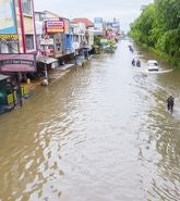
The majority of those killed on Leyte drowned within minutes of the storm surge inundation, which extended up to two kilometers inland.
Some 12,270 structures were destroyed and 46,553 were partially damaged in Tacloban. Bodies were found scattered across Tacloban City, survivors reported floating cars, and even an oceangoing freighter driven inland, all crushing houses and injuring those caught up in the flood.
Haiyan maintained its Category 5 status as it made repeated landfalls over the Philippine Island chain, and as it tracked west, towns and cities experienced similar destruction. On the other side of the island from Tacloban, the city of Ormoc (pop. ~190,000) saw more than 90 percent of buildings destroyed or damaged, and also in Bogo City on neighboring Cebu Island (pop. ~78,000). Cadiz (pop. ~150,000) had more than 5,000 structures destroyed.
More than fifteen hours after the first landfall, Haiyan made its sixth and final landfall in the Philippines on Busuanga island in Palawan province — about 550 kilometers west of Tacloban. Palawan province saw 18,761 structures destroyed or damaged.
The impact on the Philippines was huge. In total, 1.14 million structures were totally or partially damaged. 591 municipalities and 16 million people were affected; some five million accessed services from evacuation centers. Four million citizens were displaced. Economic losses were estimated at US$13 billion.
RMS Reconnaissance Findings
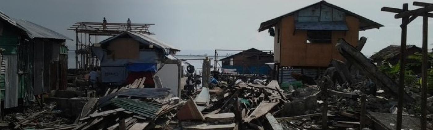
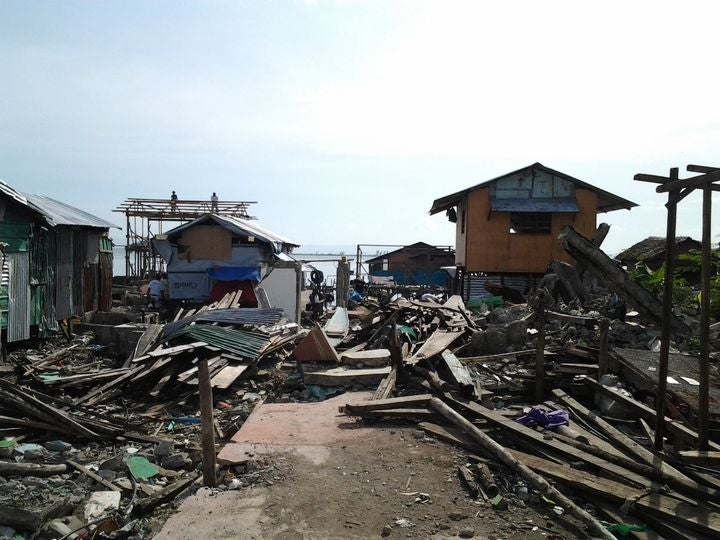
A team of RMS vulnerability developers visited a few weeks after the event to undertake damage reconnaissance, including the island of Leyte, visiting cities such as Tacloban City, and Ormoc City that saw damage to 90 percent of structures.
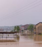
Storm surge heights of six meters were observed, which powered the worst damage. Advancing water and debris carried within it caused extensive structural damage to areas along the coast, in addition to water damage to contents and building interiors. Non-structural flood damage was evident even far inland.
Examples of timber-framed single-family dwellings that were largely destroyed after storm surge of between one to two meters. Image: RMS reconnaissance
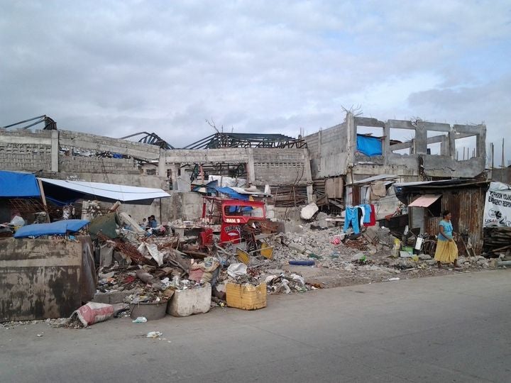
In terms of wind, while heavy damage was observed to timber, masonry, and light metal structures, those constructed with a reinforced concrete frame — the dominant construction material used to better withstand earthquake shaking, remained intact.
For these types of buildings, the main damage occurred to the roof structure, roof covering, and windows. All key findings from the Haiyan damage survey have subsequently been incorporated into the RMS Philippines Typhoon and Inland Flood Model, released earlier in 2018.
A retail complex with a reinforced concrete frame structural system failed from advancing storm surge (two to three meters high) and possibly from debris, with roof collapse due to storm winds. Image: RMS reconnaissance
The rebuild continues. Five years on, a four-meter high wall spanning 27.3 kilometers from Diit, Tacloban, through to Tanauan, is under construction and by 2020 will look to protect 33,100 structures.
Swathes of coastal land have been designated as “no-build zones”, even though they extend just 40 meters inland from the coast when storm surge can go a kilometer inland. An ambitious plan to “build-back-better” with 205,000 homes to accommodate one million people living in coastal danger zones, saw around a third built by 2017.
Haiyan was the strongest typhoon recorded in the Philippines, and at the time, the strongest tropical cyclone on record to make landfall anywhere in the world. But storms more frequently impact the northern island of Luzon; from Megi in 2010, to Mangkhut this year, though all islands are under threat. Super Typhoon Bopha in 2012 made landfall over southern Philippines as a Category 5 storm causing major damage and over 1,000 fatalities.
The Eastern Visayas itself has seen many natural disasters. Tropical Storm Thelma (Uring) in November 1991 caused over 5,000 fatalities, after a flash flood from 22 inches (580 millimeters) of rain swept through Ormoc City and the wider Leyte Island.
In November 1912, a typhoon believed to have been of similar intensity to Haiyan made landfall over Eastern Samar Island, slightly to the north of Haiyan’s landfall. Fatalities were reported to range from 300 to 15,000 people.
If Haiyan Hit Manila…
According to the RMS Philippines Typhoon and Inland Flood industry exposure database, around two-thirds of the insured exposure in the country is located in “Zone A” incorporating Metro Manila and the neighboring regions of Calabarzon and Central Luzon.
Metro Manila (pop. ~13 million) ranks as one of the most densely populated global cities, and accounts for approximately 37 percent of the gross domestic product (GDP) of the Philippines. Calabarzon and Central Luzon are also important economic centers, with significant concentrations of industrial facilities.
Typhoons regularly hit the Manila area, but not on the same scale as Haiyan. Typhoon Angela (Rosing) in 1995 brought 1-minute sustained winds to the capital of 160 kilometers per hour (100 miles per hour), while Typhoon Nesat (Pedring) in 2011 introduced Manila to the peril of storm surge, which reached one and a half meters (5 feet) along Roxas Boulevard.
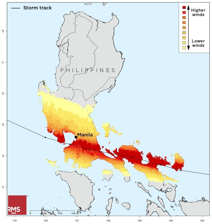
But what if a storm with the strength of Haiyan were to make a direct hit on Manila, bringing wind speeds close to 300 kilometers per hour (185 miles per hour) and a storm surge exceeding five meters (16 feet), would this even be possible?
Fortunately, the mountainous terrain to the east of the capital effectively acts as a windbreak, reducing the wind speed of typhoons before they impact the capital, making it unlikely that a Haiyan-strength storm could impact Manila, but not impossible.
Similarly, the precise combination of factors needed to produce storm surges several meters high; very strong south-westerly winds in Manila Bay combined with a high tide; also have a low probability of occurrence.
Hypothetical Haiyan storm track across Manila, generated from the RMS Philippines Typhoon and Inland Flood Model
Nevertheless, such a storm could cause widespread destruction to Manila and the surrounding regions, with heavy wind damage to roofs, windows, and poorly built structures. Damage to infrastructure, including transport systems, power, and water lines, would hamper aid and recovery efforts.
Storm surges would damage properties along the coast of Manila Bay and the area around Laguna de Bay, and combined with heavy rainfall, cause flooding far inland. 27 percent of the land area of Manila lies below ten meters above sea level, and the parts of the city are prone to regular inundation from typhoons and monsoon rains.
Using the RMS Philippines Typhoon and Inland Flood Model and corresponding industry exposure database, a Haiyan-like storm impacting the Manila region could cause upwards of US$1.2 billion of insured losses, but in terms of the probability of occurrence has a loss return period in excess of 100 years.
For such an event, the RMS model includes the impacts of post-event loss amplification, accounting for super-cat effects such as major disruption to lifelines, demand surge, and claims inflation.
A typhoon of Haiyan’s strength hitting Manila is still hypothetical, but for the Eastern Visayas, the memory of events five years ago, and the rebuilding still goes on.
Share:
You May Also Like
May 04, 2021
RMS Models Offer New Probabilistic Approach to Simplify Flood Management Across Southeast Asia
Based in London, Simon joined RMS in 2012 and works within the Product Management team, focusing on the Asia-Pacific climate suite of products. He is product manager for the RMS typhoon models for China, Taiwan, South Korea, the Philippines, and Guam, and has most recently been involved in supporting the development of new inland flood models for China and Southeast Asia.
Simon holds a bachelor's degree in Geography from the University of Nottingham and a master's degree in Geological and Environmental Hazards from the University of Portsmouth.