RMS Works With the Insurance Authority of Hong Kong on Return Period After Typhoon Mangkhut
Simon AthawesDecember 17, 2018
In September, Typhoon Mangkhut wrought a path of destruction across the western North Pacific, causing damage from Guam, to the Philippines, Hong Kong, and southern China. For Hong Kong, Mangkhut was the second strong typhoon to impact the region in consecutive years, following Typhoon Hato in 2017. Damage was extensive – according to local media, at least 500 homes and high-rise buildings in Hong Kong, including apartment complexes and office blocks, were severely damaged.
In the weeks following Mangkhut, RMS worked with the Insurance Authority (IA) – the independent insurance regulator for Hong Kong, to help provide (re)insurers in the region with some context and scientific analysis around this event. According to data from the insurers gathered by the IA, Typhoon Mangkhut caused total insured losses of HKD 3.5 billion (US$448 million) in Hong Kong. This figure, collected as at October 12, three weeks after Mangkhut’s landfall, represents losses reported by insurance and reinsurance companies in Hong Kong. With the loss information provided by the IA and using the RMS China and Hong Kong Typhoon Model, RMS estimated Mangkhut to have a return period of 30 to 40 years in Hong Kong.1
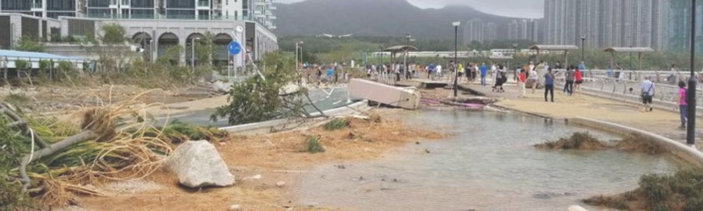
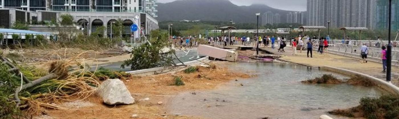
Tseung Kwan O Waterfront Park after Typhoon Mangkhut. Image: Lokka Yeung, RMS
Mangkhut: A Near Miss?
There were many factors that made Mangkhut a unique storm, all of which contributed to the high levels of damage observed in Hong Kong. At its closest point, Mangkhut came within 60 miles (100 kilometers) of Hong Kong – though this was further away than Hato, which had passed within 37 miles (60 kilometers). On its journey westwards towards Hong Kong, Mangkhut had previously crossed northern Luzon in the Philippines. This land interaction had weakened the eyewall of the storm – usually where the highest wind speeds are observed within a tropical cyclone – before it made landfall again in southern China.
But although this weakened the storm, convection within the outer spiral rainband of Mangkhut was intense, with hurricane force winds extending far from its center and over Hong Kong. Additionally, Mangkhut was a fast-moving typhoon, and the superposition of the forward speed and wind speed (highest on the right-hand side of the storm track) acted to increase the observed wind speeds in Hong Kong.
Nevertheless, there were also several mitigating factors which prevented higher levels of damage being caused by Mangkhut. As mentioned previously, the wind speeds experienced in Hong Kong would have been even higher had Mangkhut not been weakened by its land interaction with the Philippines, and if its eyewall had passed directly over Hong Kong.
Mangkhut also produced record levels of storm surge in some areas of Hong Kong, yet the storm occurred close to neap tide (when the differences between high and low tide are at their least), suggesting surge levels could have been even higher if the typhoon had coincided with a high spring tide. Rainfall levels during Mangkhut were also moderate at 180.7 millimeters, contrasting with Typhoon Sam in 1999 which produced the record typhoon precipitation of 616.5 millimeters in Hong Kong.
Worst-Case Scenarios
Record levels of insurance claims are expected in Hong Kong as a result of Typhoon Mangkhut. However, as destructive as Mangkhut was, it by no means represents the worst-case scenario for a typhoon impacting Hong Kong. As part of the IA’s proposed Risk-Based Capital (RBC) framework, insurers in Hong Kong are required to target a 1-in-200-year return period solvency level. Based on the RMS China and Hong Kong Typhoon Model, RMS estimates that a 1-in-200-year insured loss from a typhoon in Hong Kong would be in the region of HKD 15 billion to 18 billion (US$1.9 billion to US$2.3 billion).2
Such a high loss scenario in Hong Kong could arise from a category 4 storm (on the Saffir-Simpson Hurricane Wind Scale) with 1-minute maximum sustained winds of 129 miles per hour (207 kilometers per hour) or above, making landfall directly over Hong Kong Island or Lantau Island. The highest wind speeds in a typhoon are typically observed in the eyewall and in the front right quadrant of the storm, so a typhoon of this strength passing over the main exposure concentrations of Hong Kong would cause major wind damage.
The typhoon would cross Hong Kong moving in a northwesterly direction, impacting Hong Kong with the strongest winds throughout its passage. Peak wind gusts in the dense urban areas of Hong Kong City and Kowloon would exceed 105 miles per hour (168 kilometers per hour). For such a strong typhoon to make landfall in Hong Kong, it is likely to need to pass through the Luzon Strait with minimal land interaction with either the Philippines or Taiwan.
Such a strong typhoon could also bring record levels of storm surge, exceeding five meters (16 feet) in Tolo Harbour and four meters (13 feet) in Victoria Harbour, leading to severe coastal flooding. The tidal conditions at the time of storm landfall would also have a considerable influence, with the typhoon landfall coinciding with high tide, exacerbating the surge levels.
An alternative large loss scenario could be seen from a slower moving typhoon crossing Hong Kong and depositing record levels of rainfall, leading to severe flooding in Kowloon, and along the Sheung Yue, Ng Tung, Shan Pui, and Kam Tin rivers in the New Territories.
Summary
The losses experienced in Hong Kong from Typhoon Mangkhut, and also Hato in 2017, highlight the importance of catastrophe risk management and accumulation monitoring for (re)insurers in Hong Kong. Insurers also need to consider the potential 1-in-200-year return period loss to meet proposed solvency requirements and should factor this into their reinsurance management strategy.
The Insurance Authority also reminds insurers that they should exercise due diligence in setting maximum retention levels, be mindful of potential gaps in their reinsurance program, and should set their own retention levels having regard to their risk profile, risk tolerance, business strategy, capital levels and other factors relevant to their risk assessment. RMS will look to continue working with the Insurance Authority with the aim of informing and assisting (re)insurers in the region around catastrophe risk management.
Notes:
1. The midpoint of 35 years was used for the return period in the circular issued by the Insurance Authority of Hong Kong.
2. The midpoint of HKD 16.5 billion (US$2.1 billion) was used for the 1-in-200-year loss in the circular issued by the Insurance Authority of Hong Kong.
Share:
You May Also Like
May 04, 2021
RMS Models Offer New Probabilistic Approach to Simplify Flood Management Across Southeast Asia
Based in London, Simon joined RMS in 2012 and works within the Product Management team, focusing on the Asia-Pacific climate suite of products. He is product manager for the RMS typhoon models for China, Taiwan, South Korea, the Philippines, and Guam, and has most recently been involved in supporting the development of new inland flood models for China and Southeast Asia.
Simon holds a bachelor's degree in Geography from the University of Nottingham and a master's degree in Geological and Environmental Hazards from the University of Portsmouth.