Hurricane Dorian looks set to pass over the northern Bahamas in the coming days as potentially a Category 5 major hurricane, but forecasts regarding future U.S. impacts remain significantly uncertain, with the latest guidance providing a twist in the tale that no one anticipated a few days ago.
Understanding the Uncertainty: A Matter of Timing
The meteorological situation that Hurricane Dorian finds itself in is as fascinating as it is uncertain. Several days ago, Florida was bracing itself for potentially its third major hurricane landfall in as many years. Now, Dorian looks more likely to make landfall in the Carolinas, or, as some models increasingly suggest, it may recurve soon enough that is misses the U.S. entirely. So, why have the forecasts been so uncertain? It’s all to do with timing.
Dorian’s expected forward speed through the northern Bahamas is now much slower than was anticipated four days ago. This has had significant knock-on effects for the rest of the forecast. The later arrival time into the Bahamas has meant that the projected weakening of the mid-tropospheric ridge located near Bermuda is expected to allow Dorian to begin to turn north once it exits the northern Bahamas on Monday evening. With a faster forward track like the one forecast earlier this week, Dorian may not have had an opportunity to turn north and would have made landfall over southern Florida and could even traversed into the Gulf of Mexico.
Getting Ahead of the Forecasts
As is the case with Dorian, when the track forecasts are highly uncertain due to complex steering patterns or when there are multiple plausible solutions presented by the multi-model ensembles, it is sometimes best to look beyond the specific details of the deterministic solutions or individual ensemble members and instead evaluate the overall trends in the forecasts.
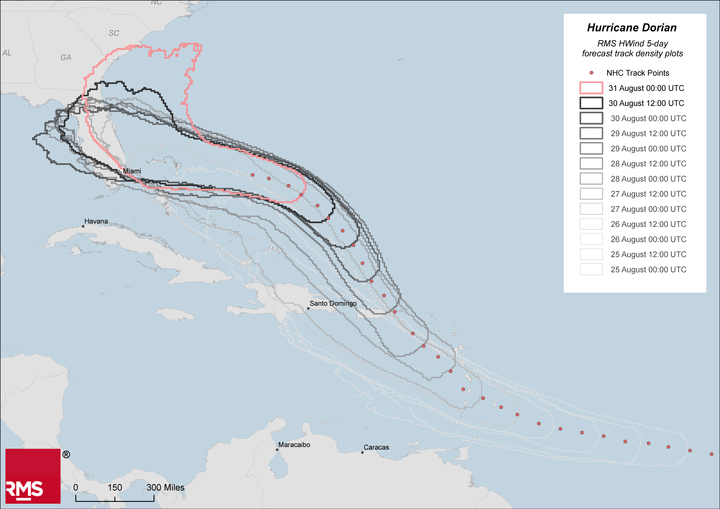
To visualize how the multi-model ensemble forecasts have been trending in recent days, we can look at the evolution of the RMS HWind 5-day forecast track density plot – see below. These are informed by over 100 multi-model ensemble members and denote where there is a five percent or greater probability of the center tracking within 50 nautical miles of a given location. Each density plot represents a different initialization time covering the period between Sunday, August 25 to 00:00 UTC today, Saturday, August 31.

There are several key takeaways from the evolution of the RMS HWind density plots:
- The multi-model ensembles have been consistent for at least the past six days in bringing Dorian through the northern Bahamas towards the U.S.
- Through Wednesday and Thursday, the farthest extent of the five-day density plot became fixated on Florida, giving a first indication that Dorian’s forward speed might reduce as it tracked nearer the southeastern U.S.
- Because of Dorian’s slower forward speed, the multi-model ensemble guidance in the past 24 hours quickly picked up on the potential for the system to turn north much sooner than previously anticipated.
- Consequently, today’s multi-model ensemble guidance has shifted to the north and east, and, depending on when Dorian turns and how quickly it accelerates northeast, it may just miss the U.S. altogether – something that was unthinkable two days ago.
While we cannot currently say with absolute certainty where Dorian will make landfall in the U.S., if at all, we can say that it is often best to see the larger picture and to follow the trends when dealing with complex steering environments. Be sure to keep an eye on the RMS blog and our social media platforms for the very latest forecast information on Hurricane Dorian.


