Hurricane Ian: A Potential Category Five Hurricane?
James CosgroveSeptember 28, 2022
A quiet North Atlantic hurricane season has certainly kicked into life, as Hurricane Ian approaches southwest Florida as a high-end Category 4 (Saffir-Simpson Hurricane Wind Scale – SSHWS) major hurricane. This is the ninth tropical storm of the current season and the fourth hurricane. Comparing this season to 2021, the ninth storm was Hurricane Ida in late August – and it was the most destructive of that year.
Ian made landfall near La Coloma on the southwest coast of Cuba yesterday (September 27) as a Category 3 major hurricane. At landfall, Ian had maximum sustained wind speeds of 125 miles per hour (205 km/h). Damages are currently being assessed, but an immediate impact from Ian was reported from the Cuban state electric company, Unión Eléctrica de Cuba, declaring a total power blackout for 11 million citizens.
Since passing over Cuba, Ian has defied the forecasts and has continued to intensify over the warm waters of the Gulf into a high-end Category 4 major hurricane, with maximum sustained winds of 155 miles per hour (250 km/h), just two miles per hour shy of Category 5 intensity.
Looking at the National Hurricane Center (NHC) forecast track, the center of Hurricane Ian is expected to move towards Florida’s west coast this morning (Wednesday, September 28) Eastern Time (ET). Eighteen counties in Florida have issued mandatory or voluntary evacuation orders.
Some fluctuations in intensity are possible before Ian reaches the coast of Florida, but at this time, the NHC forecasts Ian making landfall as a high-end Category 4 major hurricane near Port Charlotte, some ten miles north of Fort Myers/Cape Coral shortly after 18:00 UTC (14:00 ET) today (Wednesday, September 28). Ian will then move into central Florida tonight and Thursday morning, before emerging over the western Atlantic by late Thursday.
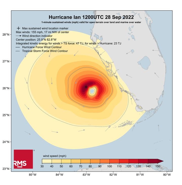
The RMS HWind team is issuing regular snapshots, footprints, and forecasts to RMS clients for Hurricane Ian, and the HWind wind field snapshot below from 12:00 UTC today (07:00 ET) shows how Hurricane Ian continued to intensify overnight.
RMS HWind Hurricane Ian wind field snapshot as of 12:00 UTC (07:00 ET) on 28 Sep 2022
Examining the HWind snapshot, the hurricane's wind field now has approximately 47 terajoules (TJ) of integrated kinetic energy which is comparable to the levels found in Hurricanes Michael (2018) and Laura (2020). Tropical storm force winds extend out some 150 miles (241 kilometers).
Catastrophic wind damage is likely where the core of Ian moves onshore and will weaken after landfall. Hurricane-force winds are expected will begin along the west coast of Florida in the coming hours.
The combination of storm surge and the tide will cause normally dry areas near the coast to be flooded by rising waters moving inland from the shoreline. The deepest water will occur along the immediate coast near and to the right of the storm's center, where the surge will be accompanied by large waves. Water levels could reach 12 to 16 feet (2.4 to 3.6 meters) in the region between Longboat Key and Bonita Beach, including Charlotte Harbor.
Heavy rainfall will spread across Florida through today and Thursday. Widespread, life-threatening catastrophic flooding is possible across portions of central Florida with considerable flooding in southern and northern Florida.
As always, the RMS Event Response team is ensuring clients are well informed of new developments on Hurricane Ian and their possible implications in terms of loss. RMS clients can access detailed information on Hurricane Ian through RMS Owl, including the latest RMS HWind data and snapshots.
Follow the RMS social media channels on Twitter and LinkedIn for updates.
Based in London, James is an Assistant Director within Moody's RMS Event Response team, supporting real-time event response operations and assisting on various event response projects. James holds a bachelor’s degree in Physical Geography and Geology from the University of Southampton and a master’s degree in Applied Meteorology from the University of Reading.