On November 13, 1972, now some 50 years ago, one of the strongest and most devastating windstorms struck Europe. Back in 1972, I was a teenager living with my family in northern Germany, and for us, this Autumn day started like any other.
My siblings and I took the train to school which was some 15 kilometers (9 miles) from where we lived. At that point, we had no idea that this day would become one that we would remember for the rest of our lives.
Quimburga, or the Lower Saxony Storm, originated on November 11, 1972, from a small circulation over the Atlantic in an area of strong meridional temperature gradients, where the cold polar air meets warm air advected north by another circulation southwest of Newfoundland.
In the following 24 hours, the system’s pressure center deepened explosively, moving quickly to first reach the British Isles and then further westwards, roughly along the Netherlands North Sea coast before entering northern Germany on November 13.
Large areas of the Netherlands, Belgium, and the northern part of today’s Germany experienced wind gusts of over 125 kilometers per hour (76 mph) and on The Brocken, the highest peak in the Harz mountains at 1,142 meters above sea level, the wind gusts reached 245 kilometers per hour (152 mph).
The estimated pressure of 953 hectoPascals (hPa) was extremely low for a European extratropical cyclone.
At my school, the wind became stronger during the morning lessons. It was quite scary as large trees started to fall and it soon became clear that pupils who lived further away would not be able to get home, as roads and train lines were covered with fallen trees.
We spent the rest of the day in the school building and when the winds eased, we transferred to the headquarters of a nearby British Army garrison. We enjoyed a meal in the canteen and ate turkey for the first time in our lives!
The roads were cleared by the evening and at last, we could go home. I remember that the power was off for several days, and my mother resorted to cooking on a gas camping stove.
Over 50 people lost their lives as a result of the storm. Transmission lines taken down by falling trees took days to repair and restore power. Several historical buildings were damaged, some very severely, with widespread severe roof damage across the affected areas.
Large swathes of forest were also downed across northern Germany, and the sheer number of fallen trees provided fuel for a very large forest fire at Lüneburg Heath in August 1975, destroying 7,418 hectares.
The devastation from the windstorm was so widespread that the forestry administration would hire anyone from the age of 15 or so, who was willing to plant new trees. And as a result, for several years planting trees became my first job during school holidays and the replanting lasted well into the 1980s.
Quantifying the Impact of The Lower Saxony Storm 50 Years Later
If Quimburga happened today, RMS estimates the gross losses to be in excess of €5 billion for the whole of Europe. This may seem to be a surprisingly large estimate and it is slightly larger than that for Kyrill in 2007, one of the strongest storms of the last 20 years.
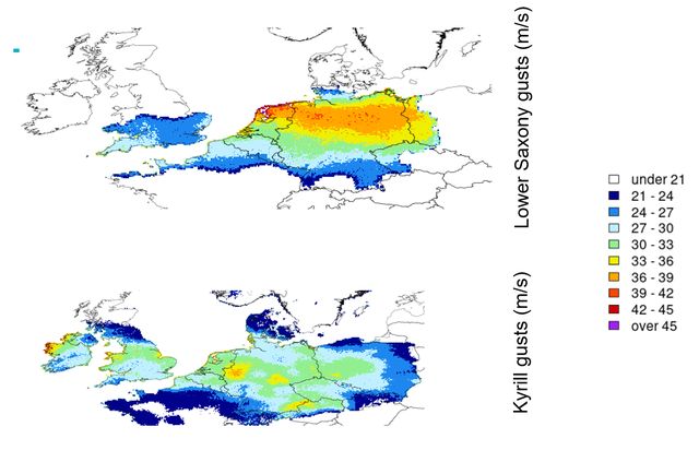
It is helpful to compare the gust footprint of Kyrill with Quimburga given the similarity between the two storms as shown in Figure 1. Kyrill, which formed in January 2007, did affect England and Wales more strongly than Quimburga, but areas of very strong gusts above 33 meters per second (119 km/h) are small and represent only a small fraction of the footprint.
However, Quimburga shows gusts in excess of 36 meters per second (130 km/h) over a very large area that extended from the Netherlands, across Northern Germany, and all the way to the western edge of Poland.
Figure 1 The upper panel shows the RMS reconstruction of footprints for the Lower Saxony Storm (or Quimburga). The lower panel shows the same for Storm Kyrill in January 2007.
This makes Quimburga one of the strongest storms in the RMS historical event catalog, which is due to be released with the upcoming RMS® Europe Windstorm HD Models in Spring 2023.
Quimburga was not only remarkable due to its strength but also because it occurred in November and was relatively early in the European windstorm season, which normally peaks later during the months of December, January and February.
Early storm warnings now allow preventive actions to be taken to lessen the loss of life and property, but in 1972 there was hardly any warning of Quimburga approaching. Today’s weather forecasts, even up to several days in advance, are significantly better compared to those of 1972, allowing for warnings to be issued to the public from most weather services three to five days ahead.
Unpacking How High-Definition Modeling Helps You Quantify the Impact of Windstorm Quimburga
Seasonal windstorm forecasts pose a different set of challenges to the scientific community compared to those for day-to-day weather forecasting. There is a complex interplay between different climate drivers which we describe in an RMS blog here, from El Niño to the Quasi-Biennal Oscillation, to the solar flux and Arctic sea ice.
This interplay has been widely investigated by the academic community using other climate indices such as the North Atlantic Oscillation and the Scandinavian Pattern.
These have led to some improvement in the predictive skills of windstorms as a weather/climate event, but the overall climatological and statistical uncertainties render the associated loss probability so uncertain, to make it useless for most risk transfer purposes. This makes the use of catastrophe models a necessity for the (re)insurance industry.
We leverage the latest data and science in our new Europe Windstorm High Definition (HD) Models, and the new historical loss estimate for Quimburga will benefit in many ways from the latest rebuild of the vulnerability module. Given the resulting widespread forest damage, the new forestry vulnerability curves will also provide an important contribution to the accuracy of the estimate.
In addition, this latest release brings several new features to the market, some of which have already been announced in two previous blogs (available here and here).
In the context of Quimburga, it is also worth mentioning that RMS conducted a thorough statistical analysis of wind gust data from 1972 onwards collected from weather stations all over Europe. This dense network of stations allowed a high-quality reconstruction of over 940 storms, far beyond the Lower Saxony event.
A large number of relatively small storms and low levels of storm activity over the last few years have made the historical and stochastic event sets more representative of the overall climate of windstorms in Europe, and as a consequence, the estimation of the cross-country correlation of losses is also more robust.
Using the HD framework also brings several innovative features to help manage European windstorm risk. Shifting from an event-based to a temporal simulation framework is particularly important because it allows for the appropriate handling of complex financial conditions, such as aggregated treaties and reinstatements.
A temporal simulation framework also allows users to natively simulate the clustering of windstorms, which is more representative of how they actually occur in reality. RMS customers will be able to test the sensitivity of the modeled losses to the clustering itself.
Another key validation exercise that many clients routinely carry out is the comparison of modeled losses against claims experience. Most (re)insurers face daunting challenges to assemble a good quality set of claims that extend back to the 1990s in order to include at least Lothar and Martin in 1999.
Not only was electronic record keeping much more limited at that time, but also the prevailing market conditions and insurance practices make the indexing of loss quite uncertain and very sensitive to the method of choice.
With these difficulties in mind, RMS is releasing the Climate Variability View (CVV) with the Europe Windstorm HD Models. It is calibrated using a more recent period of 25 years of activity and provides a useful benchmark against recent claims experience.
With a comprehensive understanding of all the assumptions underlying the CVV and the claims processing, this view will inform business decisions and will add robustness to the overall risk view.
Latest Model Developments
Just as today’s weather forecasts are significantly better than 50 years ago, the new RMS Europe Windstorm HD Models bring many enhancements to the market compared to the current RMS models. We will also share more details as they become available as the release date approaches in Spring 2023.
Going back to my experience of Quimburga in 1972, on a personal note, after finishing school, I did consider becoming a forester but then decided to study meteorology. I have never regretted this.
I am still fascinated by weather, climate, windstorms, and all the other climate perils, and have enjoyed 22 years here at RMS building catastrophe risk models for the insurance industry. And when I go back home to Lower Saxony, it is reassuring to know that all those trees that I helped plant some 50 years ago are still doing well.
Christine is leading a team of model product managers with a focus on global climate hazards. She has been with RMS for almost 22 years, working in several roles and projects including software development and software product management. She holds a Ph.D. in meteorology from the Free University of Berlin, Germany.
Giovanni has worked in the (re)insurance industry for the last 10 years with research and development roles for Property and Casualty at Zurich Insurance and Aspen Re. Previously he was a researcher at the Met Office and the University of Reading where he focused on convective scale ensembles.
He obtained his PhD in Meteorology from Colorado State University and a MSc from San Jose State University, and has earned his Laurea in Physics from the University of Bologna.