Turkey/Syria Earthquakes: Capturing the Scale of the Disaster
Robert Muir-WoodFebruary 10, 2023
There is a sense of shock around the globe as reports show the severity and extent of the damage across southern Turkey and northern Syria, and the tragic impact on the communities in those areas. As of February 10, the number of fatalities has exceeded 21,000, and the number of injured in Turkey currently stands at over 75,000.
The earthquakes have affected 13 million people across ten provinces in Turkey, and an area of approximately 42,479 square miles (110,000 square kilometers), equivalent to the size of Bulgaria. Fatalities and casualties have been reported in the Turkish provinces of Kahramanmaraş, Gaziantep, Şanlıurfa, Diyarbakır, Adana, Adıyaman, Osmaniye, Hatay, Kilis and Malatya and Elazığ.
Working Along the Fault Line
The Mw7.8 earthquake was located on the East Anatolian Fault plate boundary, a 434-mile (700-kilometer) boundary that runs northeast-southwest and separates the Anatolian Plate from the Arabian Plate.
The earthquake triggered a strong earthquake sequence of 648 subsequent earthquakes of varying magnitudes, according to the Turkish Disaster and Emergency Management Authority (AFAD). The largest, an Mw7.5 earthquake some nine hours after the Mw7.8 earthquake, caused significant damage in its own right.
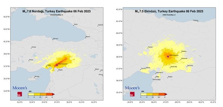
Figure 1: USGS ShakeMaps for the Mw7.8 and Mw7.5 southern Turkey earthquakes
Looking at the USGS ShakeMap for the Mw7.8 event (Figure 1) you can see the red band indicating the highest level of shaking along the East Anatolian Fault rupture, which ranges from Malatya Province in the northeast to Hatay Province in the southwest, skirting Gaziantep, Hatay, and Kahramanmaraş Provinces along its path. Working along the length of the rupture reveals the areas that have suffered the full severity of these earthquakes.
Starting at the northeast end of the rupture in Malatya Province (pop. 790,000), over 140 collapsed buildings of varying sizes were reported across the province as of February 6, a number that is still developing as damage assessments take place.
Moving southwest along the rupture to Gaziantep Province (pop. ~ 2.1 million), which borders Syria and is dominated by the city of Gaziantep (pop. ~1.7 million), a city that can trace its origins to the Neolithic Period, 6,400 buildings have been destroyed including many apartment complexes, as per reports from government officials.
In a briefing on February 9, Turkish President Recep Tayyip Erdoğan reported that 1,415 people had been killed in Gaziantep and 10,395 were injured. At the southwest edge of the province, reports from the city of Nurdagi show that over a hundred buildings have collapsed.
Across from Gaziantep Province, on the north side of the rupture is Kahramanmaraş Province (pop. 1.16 million) with the main city of Kahramanmaraş. On February 7, officials said more than 1,200 people had died in the province, but this figure is likely to rise sharply, as satellite images, social media images, and videos report significant destruction.
Three hundred buildings have so far been confirmed to have been destroyed in Kahramanmaraş, a number that is expected to rise. A tent city has been established at the 12 Şubat football stadium.
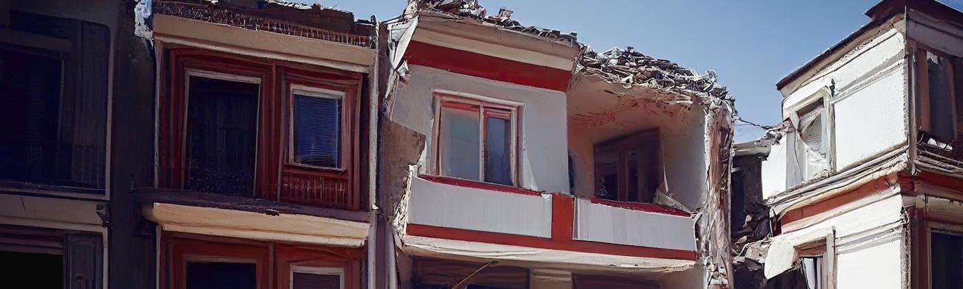
To the west of Gaziantep Province, and at the end of the rupture, is Hatay Province (pop. ~1.6 million) which includes the Mediterranean port city of İskenderun (pop. ~184,000). Drone footage reports widespread destruction with most buildings toppled or reduced to rubble.
More than 3,300 people had been killed in the province, and on February 7, Hatay’s Mayor Lütfü Savaş said that about 2,750 buildings collapsed but admitted it was early in the rescue attempts with many apartment blocks, especially in outlying areas still to be accounted for. In Antakya (pop. ~216,000), many newer structures, including schools, administrative buildings, hospitals, and even the headquarters of the country’s disaster agency, collapsed.
Some 1,200 buildings are reported as destroyed in İskenderun, including a sixteen-story building constructed in 2019 that collapsed. Hatay Airport has been destroyed and İskenderun Port reported a large fire and collapsed shipping containers.
Bordering Kahramanmaraş Province and across the coast from Hatay Province is Adana Province (pop. ~2.6 million). Here, social media images show widespread collapsed buildings. In Adana, one of Turkey’s largest cities, several high-rise apartment buildings have collapsed, and in the Yurt neighborhood of Cukurova – a district of Adana – large apartment blocks have collapsed, and multiple vehicles have been damaged.
Impact in Syria
Turkey shares a 565-mile (909-kilometer) border with Syria, and over 3,300 fatalities have been reported with more than 5,000 injured. The worst affected sub-districts include Harim, Atmeh, Sarmada, Atareb, and Kafr Takharim. Multiple northern regions of Syria are inaccessible due to blocked roads, with limited emergency services support and assessments of damage.
Reuters reported on February 9 that at least 1,930 people had been killed by the major earthquakes in opposition-held northwest Syria. Multiple buildings of varying sizes have collapsed across Aleppo causing widespread damage, with Latakia, Hama, and Idlib impacted.
Recovery and Aftermath
In Turkey, 120,334 search and rescue workers from government, NGO, and volunteer organizations are on the ground. Some 6,479 teams from countries around the world contacted the Turkish Ministry of Foreign Affairs to help and have been deployed to hardest-hit areas.
A disaster zone was declared in the 10 provinces, imposing a state of emergency for three months. Storms hampered rescue efforts on February 6-7, with high winds, heavy rain, and snow, plus temperatures dropping to minus 14 degrees Celsius towards the north of the rescue area.
For insurers coming to terms with the level of damage to property and infrastructure, all eyes turn to the Turkish Catastrophe Insurance Pool (TCIP) with a claims-paying capacity of nearly US$5 billion, according to its 2021 reinsurance renewal and 2021 exchange rate.
Examples of the take-up rate of the TCIP-backed compulsory earthquake insurance scheme across Turkish provinces include approximately 52 percent of households in Malatya Province and 65 percent in Gaziantep Province.
As the rescue efforts continue, and collapsed buildings start to be cleared, it may become evident that many more buildings that did not collapse are damaged beyond repair. Where many hundreds of buildings are destroyed, the question will be asked by authorities about what gets built in their place.
In addition, the impact on infrastructure and on businesses and industry will need to be established.
Spotlight on Building Codes
Turkey has had earthquake building regulations since 1940 and the authorities have published over ten revisions of the code, with a major revision after the Izmir earthquakes in 1999, and the latest update in 2018.
The BBC has investigated adherence to building codes and found up to 75,000 buildings across the affected earthquake zone in southern Turkey have been given construction 'amnesties,' and a few days before the latest disaster, Turkish media reported that a new draft law was awaiting parliamentary approval which would grant a further amnesty for recent construction work.
The BBC also quoted from a report by the Turkish Environment and Urbanization Ministry which stated that in 2018 more than 50 percent of buildings in Turkey – equivalent to almost 13 million buildings – were constructed in violation of regulations.
Developing building codes is sometimes the easier part. As seen with other similar tragedies around the world, you need a full ecosystem to deliver them: skilled engineers to design and oversee resilient construction, better quality materials, strict enforcement with penalties, and a commitment to safe structures.
The unfortunate loss of life and destruction of communities sadly presents another opportunity to build resilience for the future.
Clients can access the latest reports on this event via theSupport Center, or keep up to date with the latest insights on RMS social channels on Twitter and LinkedIn.
Robert Muir-Wood works to enhance approaches to natural catastrophe modeling, identify models for new areas of risk, and explore expanded applications for catastrophe modeling. Robert has more than 25 years of experience developing probabilistic catastrophe models. He was lead author for the 2007 IPCC Fourth Assessment Report and 2011 IPCC Special Report on Extremes, and is Chair of the OECD panel on the Financial Consequences of Large Scale Catastrophes.
He is the author of seven books, most recently: ‘The Cure for Catastrophe: How we can Stop Manufacturing Natural Disasters’. He has also written numerous research papers and articles in scientific and industry publications as well as frequent blogs. He holds a degree in natural sciences and a PhD both from Cambridge University and is a Visiting Professor at the Institute for Risk and Disaster Reduction at University College London.