Otis Becomes Mexico’s Strongest Landfalling Pacific Hurricane on Record
James CosgroveOctober 25, 2023
Mexico’s Record-Breaking Hurricane
Early on Tuesday, October 24, 2023, some twenty-four hours before its eventual landfall, Otis was an ordinary tropical storm located off the southwest coast of Mexico.
Otis was expected to remain at tropical storm intensity as it neared the Pacific coast and then move inland over the Mexican state of Guerrero.
Instead, Otis unexpectedly underwent a period of sustained rapid intensification.
The U.S. National Hurricane Center (NHC) confirmed that Otis made landfall in Mexico on the west Pacific coast just after midnight local time (06:25 UTC) on Wednesday, October 25, near Acapulco (pop. ~658,000), the state of Guerrero’s largest city, as a Category 5 major hurricane.
At landfall, Major Hurricane Otis had maximum sustained wind speeds of 165 miles per hour (270 kilometers per hour, 145 knots) and a central pressure of 923 hPa.
This makes Otis the strongest hurricane on record to make landfall on Mexico‘s Pacific coastline, surpassing Hurricane Patricia which made landfall with winds of 150 miles per hour (240 kilometers per hour) on October 23, 2015.
Otis is also the first ever Category 5 major hurricane to make landfall from the Eastern North Pacific since records began.
As daylight began to break over Acapulco this morning, initial reports suggest the damage from Otis is catastrophic, and local residents and meteorologists are all asking one question: why was its intensification missed by all the models?
Unexpected Rapid Intensification
The rapid intensification of tropical cyclones – officially defined as an increase in a storm’s intensity by 30 knots (35 miles per hour, 56 kilometers per hour) or greater in any 24-hour period – is challenging to forecast.
According to Mark DeMaria, a former National Oceanic and Atmospheric Administration (NOAA) hurricane forecaster and now a senior research scientist at Colorado State University, current forecast models only accurately predict rapid intensification 32 percent of the time they occur. Otis is one such occasion when the onset of rapid intensification was ‘missed’ or at least identified late.
No hurricane or global deterministic forecast model available early on October 24 had indicated that Otis was on the brink of rapid intensification.
In fact, only a few European Centre for Medium-Range Weather Forecasts (ECWMF) and Global Forecast System (GFS) ensemble members had predicted that Otis would even attain Category 1 hurricane intensity prior to reaching the west coast of Mexico.
That estimation was updated in the next NHC advisory issued six hours later at 09:00 UTC on October 24, when satellite analysis and the updated global operational forecast cycle revealed a stronger system, that was expected to intensify and to reach hurricane intensity prior to landfall.
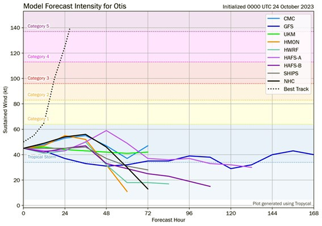
Figure 1: The chart above shows a comparison of the model forecasts (solid lines, various colors) for the intensity of Major Hurricane Otis, initialized at 00:00 UTC on Tuesday, October 24, compared to the observed intensity (dashed line). Source: Tomer Burg via X/Twitter.
By 15:00 UTC on October 24, Otis had become better organized. Cold-topped convection was observed within its central dense overcast (CDO), and it was surrounded by several convective banding features.
Dvorak intensity estimates – a statistical method for estimating the intensity of tropical cyclones from subjective interpretation of satellite imagery, did indicate a system on the brink of hurricane intensity.
At the same time, the Statistical Hurricane Intensity Prediction Scheme (SHIPS) rapid intensification indices showed a greater than normal (>25 percent) probability of rapid intensification as the system neared the coast of Mexico.
The warning signs that Otis could explosively intensify had started to emerge.
A U.S. Air Force Reserve Unit Hurricane Hunter aircraft was deployed to investigate Otis and provide real-time observations from the heart of the storm.
The aircraft penetrated its eyewall at around 19:00 UTC and 20:00 UTC on October 24 and found that the maximum sustained winds had increased to nearly 110 knots (127 miles per hour, 204 kilometers per hour) over a very small area near its center, while the central pressure remarkably dropped around 10 hPa from the first to the second center pass through.
This data proved invaluable, both to observe the hurricane’s current intensity and to better initialize the dynamical forecast models – continuous data assimilation of these observations has been shown to decrease forecasted intensity errors.
The NHC called out the importance of the flight reconnaissance in its technical discussion, stating “… the intensity of Otis is well above the Dvorak satellite estimates, and again underscores the value of aerial reconnaissance in monitoring hurricanes.”
Based on the available data and new forecast information, Otis had attained major hurricane intensity and was still intensifying.
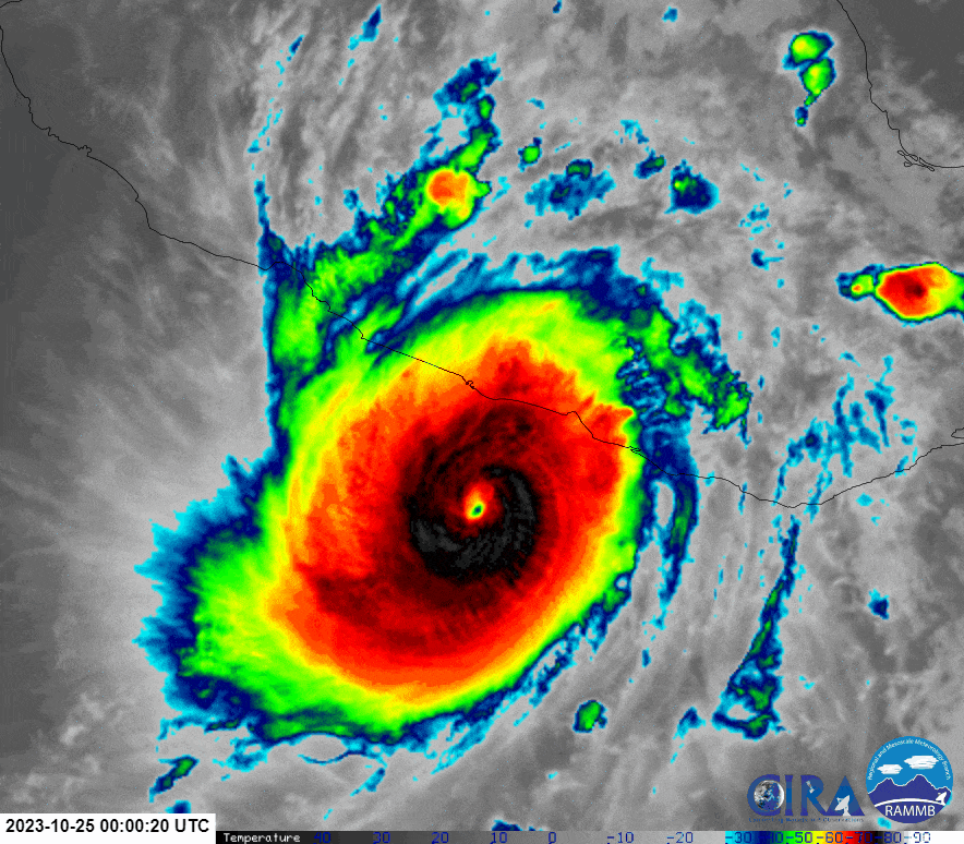
Figure 2: 24-hour satellite loop of Otis’ rapid intensification from a tropical storm to a Category 5 major hurricane prior to landfall near Acapulco, Guerrero on the west coast of Mexico. Source: CSU-CIRA /RAMMB
Otis continued to take advantage of the conducive environmental conditions, which consisted of light to moderate vertical shear and sea surface temperatures of 29 to 30 degrees Celsius (84 to 86 degrees Fahrenheit) and it continued to intensify beyond expectations.
The storm had attained Category 5 major hurricane intensity at 06:00 UTC (00:00 local time) on Wednesday, October 25 as it neared the coast, just tens of kilometers from the city of Acapulco, in Guerrero state.
The NHC reported that it was a ‘… nightmare scenario …’ with ‘… no hurricanes on record even close to this intensity for this part of Mexico.’
By the time it made landfall, Otis had intensified by 95 knots (110 miles per hour, 175 kilometers per hour) in the 24-hour period to 06:00 UTC on Wednesday, October 25.
Its rate of intensification was three times the criteria for ‘rapid intensification’ – a rate only exceeded in the Eastern North Pacific basin by Hurricane Patricia in 2015, a storm that intensified by 105 knots (120 miles per hour, 195 kilometers per hour) in 24 hours.
Patricia’s rapid intensification and peak intensity were situated over water, whereas Otis continued to intensify right up to the moment its center crossed the coastline. The intensification rate of Otis is likely to be among the top ten all-time rates of intensification.
Major Hurricane Otis: Implications
While hurricane warnings were issued twenty-four hours before landfall, this was when the forecasts called for a Category 1 landfall. Only within twelve hours of landfall did the forecast landfall intensity increase to a Category 4 major hurricane.
The full extent of the wind, storm surge, and rainfall damage in Guerrero will emerge over the coming days. Nevertheless, Hurricane Otis provides a new data point for studying rapid intensification, and one that will need to be learned from for the future.
A Trusted Partner
As a trusted partner, Moody’s RMS is ready to inform critical business processes and decisions with reliable information and analytics during the year’s most challenging events, including through data and more comprehensive analytics supplied to our cloud-native applications.
The Moody’s RMS Event Response team is ensuring Moody’s RMS clients are well informed of global tropical cyclone activity with regular updates for clients on the Support Center.
Follow the Moody’s RMS social media channels on Twitter and LinkedIn for updates.
Based in London, James is an Assistant Director within Moody's RMS Event Response team, supporting real-time event response operations and assisting on various event response projects. James holds a bachelor’s degree in Physical Geography and Geology from the University of Southampton and a master’s degree in Applied Meteorology from the University of Reading.