The Kahramanmaraş Earthquake Sequence: Moody’s RMS Commitment to Accurate and Reliable Information
Nilesh ShomeJuly 11, 2023
On Monday, February 6, a magnitude Mw7.8 earthquake struck southern Turkey, an earthquake that then caused many aftershocks, including three with a magnitude greater than Mw6. In addition, a magnitude Mw7.5 event struck approximately nine hours after the mainshock.
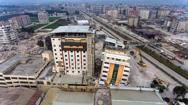
This devastating series of events caused a significant loss of life and widespread damage across an area estimated at 350,000 square kilometers (140,000 square miles) extending across southern Turkey and northern Syria.
After every major event, the catastrophe modeling community always wants to understand what happened, establish the extent of the devastation, and work to deliver accurate estimates of the damage and subsequent losses.
With an event of this scale, this work has presented significant challenges for catastrophe modelers, including the occurrence of relatively higher magnitude triggered events within a close distance (around 80 kilometers or 50 miles) all happening within a short timeframe, together with a complex fault rupture.
With a track record of event reconnaissance over the last 30 years, which sees Moody's RMS at major seismic events across the globe, our team sprang into action and collected over 250 ground motion recordings available from the Turkey Disaster and Emergency Management Authority (AFAD) as input to the modeling parameters of the event.
Additionally, we then analyzed the damage statistics provided by the Turkish Ministry of Environment, Urbanization, and Climate Change – a damage assessment study involving approximately 7,000 trained personnel who conducted on-site surveys of buildings.
The Moody's RMS team also talked to the surveyors involved in the study and evaluated the inspection guidelines, to estimate damage ratios for assessing building vulnerability functions.
Moody’s RMS: Initial Response and Market Engagement Within Fifteen Hours
Like our response to other major catastrophic events, as soon as this event was reported, Moody's RMS Event Response team recognized its major significance, and they promptly delivered an initial assessment of the Kahramanmaraş event to clients.
This included accumulation information that was delivered on the same day as the earthquakes and within 15 hours of the first earthquake. This accumulation information helped our clients assess the affected areas, reflecting on both the initial and the triggered earthquake.
Moody's RMS released an estimate of the insurance industry loss on February 23, with an estimate that was likely to exceed US$5 billion. However, there are many challenges when estimating losses when the impact of the event is still unfolding.
Our team has worked tirelessly in collaboration with various research organizations and institutions to provide an accurate estimation of the losses incurred, and having access to station recording data gave us confidence in estimating ground-motion footprints for loss assessment.
Use of Vulnerability Functions
Nevertheless, the observed damage statistics indicated that Moody's RMS modeling assumptions regarding building performance improvements – based on the lessons learned from the 1999 İzmit earthquake, may have been overly optimistic.
As a result, Moody's RMS recommended using pre-1999 vulnerability functions to improve the accuracy of loss estimation.
The most significant challenge, however, was the hyperinflation experienced in Turkey in 2022 with the consumer price inflation rate in the country reaching approximately 70 percent in the last year.
This substantial inflation rate meant that the value of properties significantly increased during the policy terms, resulting in much higher costs for repairing damages compared to the initial estimates made at the start date of the policies.
Additionally, given the extent of the damage, there is also an anticipated surge in repair costs due to the high demand for building repairs.
The extensive damage to infrastructure and utilities will also have a significant effect on business interruption loss for the commercial and industrial sectors. All these factors contribute to significant uncertainty in estimating losses for the event.
Communication and Collaboration
To aid the understanding of our loss estimates and our process for evaluation, the economic and industry loss results were accompanied by a client-focused webinar that explained the modeling details and validation of model parameters.
Furthermore, our thought leaders and spokespeople within Moody's RMS have been actively engaged in communicating the event's impact on both the industry and society to various news and media outlets, including the Financial Times, Bloomberg News, and Sigortacı Gazetesi.
They have also been sharing insights and information regarding the consequences of the event, fostering a better understanding of its impact at the Sigorta Tatbikatçıları DerneğiKahramanmaraş Earthquake virtual conference and at the Global Earthquake Model (GEM) conference in Italy, with both events held in June.
Given the complexity of the event and its devastating impact on both society and the industry, Moody's RMS used various communication channels to keep the industry informed and updated.
This commitment to providing timely and relevant information will continue in the weeks and months to come, as we recognize the importance of keeping stakeholders informed about the ongoing developments and their implications.
Ongoing Evaluation
These infrequent, large loss events such as the Kahramanmaraş earthquake sequence, often referred to as ‘tail’ events,play a crucial role in shaping the understanding of earthquake risk.
The insurance industry consistently gains new insights and a deeper understanding of risks in a region through the analysis of such significant events, and the 2023 Kahramanmaraş earthquake is no exception.
Lessons learned from the events can be used to inform modeling assumptions across all earthquake model components. Moody's RMS is now actively seeking damage and insurance claims data to assess the current vulnerability functions and enhance our understanding of the risk.
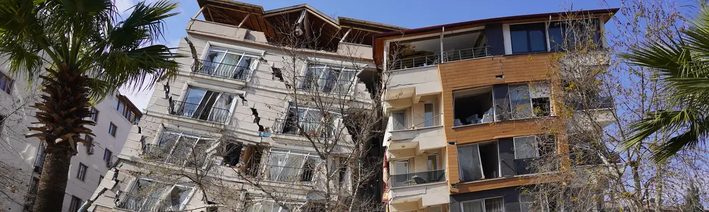
Tower block collapse in Antakya, Hatay Province
The ground-motion data obtained from this earthquake will be instrumental in improving the regionalization of the models. Moody's RMS has established itself as a leader in the industry by implementing basin models worldwide, which especially helps to improve loss estimation for mid-rise to tall buildings.
The impact of basin amplification on ground motion, as witnessed in the devastating effects in Hatay Province during the Turkey earthquake, underscores the importance of modeling basins.
We are actively seeking collaborations with local researchers to develop basin models specifically tailored for Turkey.
Our goal is to enhance our current understanding of earthquake risk and contribute to creating a better and safer living environment.
Nilesh leads the global earthquake model development group at Moody’s RMS. He joined RMS in 2009, and in addition to earthquake model development, he has also worked on the development of hurricane vulnerability functions, Moody's RMS terrorism model, and the simulation framework for Moody’s RMS High-Definition (HD) models.
Prior to joining RMS, Nilesh worked for about 10 years in the catastrophe modeling industry, developing models for earthquakes, hurricanes, and terrorism. He has also worked on or advised many Federal Emergency Management Agency (FEMA) research projects.
Nilesh holds a Ph.D. in Civil Engineering from Stanford University, where he carried out research on developing a framework for earthquake risk assessment of buildings. He received an Outstanding Research Paper Award from the Earthquake Engineering Research Institute (EERI) for the research publication. He has authored a number of papers in peer-reviewed journals.
Nilesh is also a member of the Steering Committee for U.S. Geological Society National Hazard Mapping Program.